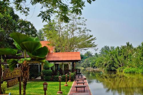
Attraction วนอุทยานทุ่งบัวตอง Thung Buatong Forest Park : แม่ฮ่องสอน
วนอุทยานทุ่งบัวตอง (ทุ่งบัวตอง, ดอกบัวตอง)

วนอุทยานทุ่งบัวตอง Thung Buatong Forest Park
![]()
ข้อมูลทั่วไป วนอุทยานทุ่งบัวตอง หรือทุ่งบัวตองดอยแม่อูคอ อยู่ในท้องที่ บ้านแม่อูคอ หมู่ที่ 6 ตำบลแม่อูคอ อำเภอขุนยวม จังหวัดแม่ฮ่องสอน อยู่ในเขตป่าสงวนแห่งชาติป่าแม่สุรินทร์ มีเนื้อที่ประมาณ 4,437 ไร่ กรมป่าไม้ได้ประกาศเป็นวนอุทยานเมื่อวันที่ 21 กรกฎาคม 2542
![]()
![]()
ลักษณะภูมิประเทศ วนอุทยานทุ่งบัวตอง ตั้งอยู่บนภูเขาสูงจากระดับน้ำทะเลปานกลางประมาณ 1,600 เมตร มีทิวทัศน์สวยงาม มองเห็นภูเขาสลับซับซ้อนคล้ายคลื่นในทะเล ในบริเวณพื้นที่ของวนอุทยานฯจะมีป่าธรรมชาติและป่าสนปลูกขึ้นสลับกัน
![]()
![]()
ลักษณะภูมิอากาศ มีอากาศเย็นตลอดปี ฤดูหนาวอากาศหนาวมาก ตอนเช้าจะมีหมอกทึบ ตอนกลางวันอากาศเย็น เพราะมีลมพัดตลอดวัน
![]()
![]()
พืชพรรณและสัตว์ป่า ป่าดิบเขาและป่าสนเขา ป่าดิบเขาส่วนใหญ่จะพบบริเวณด้านทิศเหนือและทิศตะวันตกของทุ่งบัวตอง บริเวณลาดเขาและหุบเขามีพันธุ์ไม้ที่พบได้แก่ ก่อเดือย ก่อแป้น ก่อนก เป็นต้น ป่าสนเขาจะพบบริเวณด้านทิศตะวันออกและทิศใต้ของทุ่งบัวตอง เป็นป่าที่ปลูกขึ้นใหม่โดยออป.ตามเงื่อนไขสัมปทานป่าไม้ พันธุ์ไม้ที่พบได้แก่ สนสองใบ และสนสามใบ สัตว์ป่าที่พบได้แก่ ไก่ป่า ลิง ค่าง บ่าง ชะนี อีเห็น ชะมด เม่น ตะกวด กระรอก กระแต กระต่ายป่า พังพอน ตุ่น หนู อ้น งู และนกชนิดต่าง ๆ
![]()
![]()
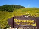
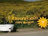
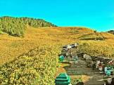
แหล่งท่องเที่ยว ทุ่งบัวตองเป็นแหล่งท่องเที่ยวตามธรรมชาติที่มีชื่อเสียงมากแห่งหนึ่งของจังหวัดแม่ฮ่องสอน มีจุดเด่นที่เป็นทุ่งที่มีดอกบัวตองซึ่งเป็นดอกไม้สีเหลืองขึ้นเป็นจำนวนมาก อยู่บนภูเขาสูง เห็นวิวทิวทัศน์รอบ ๆ ทุ่งบัวตองเป็นภูเขาสลับซับซ้อนสวยงามมาก มีอากาศเย็นตลอดปี มีหมอกปกคลุมในตอนเช้า
![]()
![]()
น้ำตกแม่สุรินทร์ น้ำตกแม่สุรินทร์ อยู่ในเขตอุทยานแห่งชาติแม่สุรินทร์ อยู่ทางทิศเหนือของทุ่งบัวตอง ห่างจากทุ่งบัวตอง 11 กิโลเมตร และห่างจากอำเภอขุนยวม 37 กิโลเมตร
![]()
![]()
โครงการอนุรักษ์กล้วยไม้รองเท้านารี โครงการอนุรักษ์กล้วยไม้รองเท้านารี อยู่ทางทิศตะวันออกเฉียงเหนือของทุ่งบัวตอง ห่างจากทุ่งบัวตอง 6 กิโลเมตร ห่างจากอำเภอขุนยวม 32 กิโลเมตร
![]()
![]()
น้ำตกแม่ยวมหลวง น้ำตกแม่ยวมหลวง เป็นน้ำตกขนาดเล็ก อยู่ทางทิศใต้ของทุ่งบัวตอง อยู่ห่างจากทุ่งบัวตอง 11 กิโลเมตร ห่างจากอำเภอขุนยวม 15 กิโลเมตร
![]()
![]()
สถานที่ติดต่อ วนอุทยานทุ่งบัวตอง อ. ขุนยวม จ. แม่ฮ่องสอน 58140 โทรศัพท์ 0 5361 2078 โทรสาร 0 5361 2078
![]()
![]()
การเดินทาง รถยนต์ เส้นทางเข้าสู่ทุ่งบัวตองมี 2 เส้นทาง คือ ตามทางหลวงแผ่นดินหมายเลข 108 ตรงหลักกิโลเมตรที่ 201 แยกเข้าทางหลวงหมายเลข1263 ไปประมาณ 12 กิโลเมตร แล้วแยกเข้าทางสายบ้านนางิ้ว-บ้านหัวฮะ ไปอีก 14 กิโลเมตร จากอำเภอแม่แจ่ม จังหวัดเชียงใหม่ ตามทางหลวงหมายเลข 1263 (แม่-แจ่ม-ขุนยวม) ถึงทางแยกเข้าบ้านนางิ้ว-บ้านหัวฮะ ระยะทาง 76 กิโลเมตร แล้วแยกเข้าไปอีก 14 กิโลเมตร
![]()
![]()
ที่จอดรถ มีลานจอดรถให้บริการแก่นักท่องเที่ยว
![]()
![]()
ศูนย์บริการนักท่องเที่ยว มีศูนย์บริการนักท่องเที่ยว ให้บริการข้อมูลเกี่ยวกับวนอุทยาน นักท่องเที่ยวสามารถเข้ามาขอรับบริการข้อมูลได้ทุกวัน ไม่เว้นวันหยุดราชการ ระหว่างเวลา 8.00 - 16.30 น.
![]()
![]()
General Information
![]()
Topography Tung Bua Tong Forest Park located on the mountain where is 1,600 metres above the average sea level. There’s beautiful scenery that is like complex ocean waves. In this forest park area, natural forest is grown mixed with planted pine forest.
![]()
![]()
Climate Cool throughout the year. It is very cold in the winter. There are heavy fogs in the morning and cold during the day because of the wind blows all day long.
![]()
![]()
Flora and Fauna It’s Hill Evergreen Forest and Pine Evergreen Forest. Most of Hill Evergreen Forest has been found in the north and west of Tung Bua Tong. Flora species grown around the hill slope and valley consist of Castanopsis species and so on.
![]()
![]()
In the eastern and southern part of Tung Bua Tong, Pine Evergreen Forest has been found. It’s planted by the Forest Industry Organisation based on its concession condition. Flora species found are Pinus merkusii and Pinus kesiya.
![]()
![]()
Tourist Attractions Tung Bua Tong (Wild Sunflower Field) is one of the most famous tourist attractions in Mae Hong Sorn Province. Its significant character is the area is largely decorated of yellowish wild sunflowers, located on high mountain where you can see scenery of vivid wild sunflower mountain range. The weather is cool throughout the year and there’s fog covered in the morning.
![]()
![]()
Mae Surin Waterfall Mae Surin Waterfall located in Mae Surin National Park, on the north of wild sunflower field. The waterfall is 11 kms and 37 kms far from wild sunflower field and Khun Yuam District respectively.
![]()
![]()
The Paphiophedilum sp. Conservation project The Paphiophedilum sp. Conservation project is on the northeastern wild sunflower field, 6 kms far from the field and 32 kms far from Khun Yuam District.
![]()
![]()
Contact Address Thung Buatong Forest Park Amphur Khun Yuam Mae Hong Son Thailand 58140Tel. 0 5361 2078 Fax 0 5361 2078
![]()
![]()
How to go? By Car there are 2 roads accessible to Tung BuaTong Forest Park as follows:
![]()
![]()
Take the Highway no. 108 at the milestone no. 201, junction to Highway no. 1263 for about 12 kms. Then head to Ban Nga Ngew-Ban Hua Ha route and drive further for 14 kms, you will reach the Tung Bua Tong Forest Park
![]()
![]()
Take the Highway no. 1263 (Mae Cham-Khun Yuam) From Mae Cham District, Chiang Mai Province to the junction to Ban Nga Ngew-Ban Hua Ha which takes about 76 kms. Then drive further for about 14 kms to reach the Tung Bua Tong Forest Park
![]()
![]()
Latitude : 18.890040949065508, Longitude : 98.09295469648205
View Larger Map

View On Google Map
Edit Data
Images
-
วนอุทยานทุ่งบัวตอง Thung Buatong Forest Park
-

วนอุทยานทุ่งบัวตอง Thung Buatong Forest Park
-

วนอุทยานทุ่งบัวตอง Thung Buatong Forest Park
-
วนอุทยานทุ่งบัวตอง Thung Buatong Forest Park
-
วนอุทยานทุ่งบัวตอง Thung Buatong Forest Park
-
วนอุทยานทุ่งบัวตอง Thung Buatong Forest Park