Attraction ทุ่งกุลาร้องไห้ THUNG KULA RONG HAI : ร้อยเอ็ด
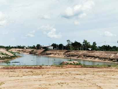
ทุ่งกุลาร้องไห้ เป็นทุ่งกว้างใหญ่ของภาคอีสาน มีอาณาเขตครอบคลุมถึง 5 จังหวัด คือ ในแนวทิศเหนือนั้นครอบคุลมอำเภอปทุมรัตน์ อำเภอเกษตรวิสัย และอำเภอสุวรรณภูมิ ของจังหวัดร้อยเอ็ด ในแนวทิศใต้มีลำน้ำมูลทอดยาวตลอดพื้นที่อำเภอชุมพล บุรี อำเภอท่าตูม จังหวัดสุรินทร์ ในแนวทิศตะวันตกผ่านอำเภอพุทไธสง จังหวัดบุรีรัมย์ อำเภอมหาชนะชัย จังหวัดยโสธร และอำเภอพยัคฆภูมิพิสัยของจังหวัดมหาสารคาม
ทุ่งกุลาร้องไห้ THUNG KULA RONG HAI
![]()
ซึ่งในพื้นที่ทุ่งกุลาร้องไห้ประมาณ 3 ใน 5 นั้น อยู่ในเขตจังหวัดร้อยเอ็ด ทุ่งกุลาร้องไห้มีเนื้อที่กว้าง 2,107,681 ไร่ สาเหตุที่ทุ่งกว้างแห่งนี้ได้ชื่อว่าทุ่งกุลาร้องไห้นั้น ก็ด้วยมีเรื่องเล่ากันว่าพวก กุลาซึ่งเป็นพวกที่เดินทางค้าขายระหว่างเมืองต่าง ๆ ในสมัยโบราณได้ชื่อว่าเป็นนักต่อสู้ คือ มีความเข้าแข็งอดทนเป็นเยี่ยม แต่เมื่อพวกกุลาเดินทางมาถึงทุ่งนี้ ได้รับความทุกข์ยากเป็นอันมากจนถึงกับร้องไห้ เพราะตลอดทุ่งนี้ไม่มีน้ำหรือ ต้นไม้ใหญ่เลย ฤดูแล้งแผ่นดินก็แห้งแตกระแหง ปัจจุบันทุ่งอันกว้างใหญ่นี้ได้รับการพัฒนาจากส่วนราชการและหน่วยงานต่าง ๆ บางแห่งก็ทำการเกษตรกรรม บางแห่งก็ใช้เป็นทุ่งเลี้ยงสัตว์ ซึ่งนับแต่จะมีความอุดมสมบูรณ์ขึ้นเรื่อย ๆ ศูนย์พัฒนาทุ่งกุลาร้องไห้ห่างจากที่ว่าการอำเภอสุวรรณภูมิ 6 กิโลเมตร เลยกู่พระโกนาไปเล็กน้อย
![]()
![]()
THUNG KULARONGHAI
![]()
This is a large plot of land in the northeast occupying an approximate area of 2,000,000 rai. The area covers the vicinities of five provinces : Surin, Roi Et, Maha Sarakham, Buriram, and Yasothon. The reason why this large field is called Kula Ronghai is that the Kula tribal people who travelled for trading in this area in the ancient times though they were healthy, tough, and very patient, however, could not stand for serious hardship when they travelled across this field thus causing them to cry since they could not find any water source nor shady area in the field at all. During summer time the ground is hard and having broken surface as pits all over. At present, the field is being developed by various governmental and nongovernmental offices thus causing some plots of the field become crop lands and some plots are used for animal raising. It is recognized that from now on the field will gradually become more fertiled and richer. Thung Kula Ronghai Development Center is located six kilometers from the office of Amphoe Suwannaphum .just a short distance beyond Ku Phra Kona.
![]()
![]()
Latitude : 15.467996237937545, Longitude : 103.67935295724723
View Larger Map

View On Google Map
Edit Data
Images
-
ทุ่งกุลาร้องไห้ THUNG KULA RONG HAI
-
ทุ่งกุลาร้องไห้ THUNG KULA RONG HAI
-
ทุ่งกุลาร้องไห้ THUNG KULA RONG HAI
-
ทุ่งกุลาร้องไห้ THUNG KULA RONG HAI
-

ทุ่งกุลาร้องไห้ THUNG KULA RONG HAI
-

ทุ่งกุลาร้องไห้ THUNG KULA RONG HAI