Attraction วนอุทยานภูสิงห์-ภูผาผึ้ง Phu Sing-Phu Pha Phueng Forest Park : อำนาจเจริญ
วนอุทยานภูสิงห์ - ภูผาผึ้ง ท้องที่ตำบลนกทา ตำบลเหล่าพรวน ตำบลคึมใหญ่ อำเภอเมือง และ ตำบลโนนงาม อำเภอปทุมราชวงศา จังหวัดอำนาจเจริญ ในเขตป่าสงวนแห่งชาติป่าดงบังอี่ ดงหัวกอง มีเนื้อที่ประมาณ 10,000 ไร่

วนอุทยานภูสิงห์-ภูผาผึ้ง Phu Sing-Phu Pha Phueng Forest Park
![]()
ลักษณะภูมิประเทศ เป็นภูเขาสูงสลับซับซ้อนกันเป็นเทือกยาวในชั้นระดับความสูงจากระดับน้ำทะเลประมาณ 200- 300 เมตร บางส่วนเป็นลานหินกว้างและหน้าผาสูงชัน มีถ้ำขนาดกลาง – เล็กหลายแห่งอยู่และเป็นแหล่งต้นน้ำลำห้วยสีโท ห้วยทราย
![]()
พืชพรรณและสัตว์ป่า เนื่องจากสภาพพื้นที่เป็นดินทรายและมีหินอยู่เป็นจำนวนมาก สภาพป่าส่วนใหญ่เป็นป่าเต็งรังผสมกับป่าเบญจพรรณ ทำให้พันธุ์ไม้ที่ขึ้นอยู่เป็นชนิดที่มีความทนทานต่อความแห้งแล้งได้ดี ได้แก่ เต็ง รัง มะค่าโมง มะค่าแต้ แดง ตะแบก ประดู่ ไผ่ป่า ยอป่า
![]()
ถ้ำยาว ถ้ำยาว เป็นถ้ำหินทรายขนาดใหญ่ ซึ่งเคยเป็นที่หลบซ่อนของผู้ก่อการร้ายคอมมิวนิสต์ในภาคอีสาน
![]()
พระพุทธรูปบนยอดภูผาผึ้ง พระพุทธรูปบนยอดภูผาผึ้ง เป็นพระพุทธรูปปูนปรางค์สมาธิซึ่งเป็นที่สักการะของชาวบ้านในบริเวณนี้
![]()
ภูผาผึ้ง ภูผาผึ้ง เป็นหน้าผาที่มาจากสภาพพื้นที่ซึ่งเป็นภูเขาที่มีรังผึ้งอาศัยอยู่ใต้หน้าผา
![]()
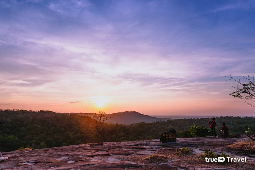
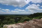
ภูผาส่อง ภูผาส่อง เป็นหน้าผาซึ่งเป็นจุดชมวิว มองเห็นทิวทัศน์โดยรอบ
![]()
อ่างกบ อ่างกบ เป็นปรากฏการณ์ของหินมีลักษณะเป็นแอ่งขนาดไม่ใหญ่นัก หรือที่เรียกว่า POT HOLE เกิดจากทรายและหินขนาดเล็กในแอ่งน้ำเมื่อน้ำไหลผ่านนานเข้าทำให้เกิดการกัดเซาะแอ่งนั้นจนมีขนาดลึกและใหญ่ขึ้น ปรากฏการณ์นี้ใช้เวลานับหลายร้อยปี
![]()
ทางเดินเท้าบนภูผาผึ้ง ทางเดินเท้าบนภูผาผึ้ง ผ่านจุดชมวิวหลายแห่ง มีพันธุ์พืชที่มีลักษณะแปลกตา ทั้งที่อยู่บนต้นไม้หรือบนพื้นดิน
![]()
ก้อนหินทรายขนาดใหญ่ ก้อนหินทรายขนาดใหญ่ มีรูปร่างคล้ายกบหรือคล้ายเต่า เมื่อมองในมุมที่ต่างกัน
![]()
สถานที่ติดต่อ วนอุทยานภูสิงห์ - ภูผาผึ้งอ. เมืองอำนาจเจริญ จ. อำนาจเจริญ 37000โทรศัพท์ 0 4528 1754 โทรสาร 0 4531 1683
![]()
การเดินทาง
![]()
รถยนต์ ห่างจากจังหวัดอำนาจเจริญประมาณ 14 กิโลเมตร เป็นทางลาดยางและเลี้ยวซ้ายเป็นทางลูกรังเข้าไป บริเวณพื้นที่ป่าประมาณ 6 กิโลเมตร เข้าถึงวนอุทยาน ใช้ได้ทุกฤดู ห่างจากจังหวัดอุบลราชธานี ประมาณ 80 กิโลเมตร
![]()
รถโดยสารประจำทาง มีทั้งรถธรรมดา และรถปรับอากาศ สายกรุงเทพฯ-อำนาจเจริญ ออกจากสถานีขนส่งสายตะวันออกเฉียงเหนือ ถนนกำแพงเพชร หมอชิต 2 สอบถามรายละเอียดเพิ่มเติมได้ที่โทร. 0 2936 1880, 0 2936 0657, 0 2936 2852-66 www.transport.co.th
![]()
รถไฟหรือเครื่องบิน สำหรับผู้ที่ใช้บริการทางเครื่องบิน และรถไฟจะต้องลงที่จังหวัดอุบลราชธานีแล้วต่อรถโดยสารมาที่จังหวัดอำนาจเจริญอีกประมาณ 75 กิโลเมตร
![]()
![]()
Phu Singh-Phu Pha Pheung Forest Park located in Nok Tha Sub-district, Lao Pruan Sub-district and Keum Yai Sub-district in Muang District; and Non Ngam Sub-district, Pathum Ratchawongsa, Amnat Charoen Province, situated in Dong Bung Ei-Dong Hua Kong National Reserved Forest, covered the area of approximately 10,000 rais. The Royal Forest Deaprtment declared this forest park on August 26, 1996.
![]()
Topography It’s mountain range, 200-300 metres above the average sea level. Some part of it is large stone ground and high cliff. There are many small and medium-sized caves. It’s a watershed area for Huay Sii Toh Stream and Huay Sai Stream.
![]()
Flora and Fauna Because the area is full of sandy soil and large amount of rock, therefore its forest mostly is Dry Deciduous Dipterocarp Forest combined with Mixed Deciduous Forest. This cause those trees grown become strong and well stand to the drought, for instance Shorea obtusa, Shorea siamensis, Afzelia xylocarpa, Sindora siamensis, Xylia xylocarpa, Lagerstroemia sp., Pterocarpus macrocarpus, Bambusa arundinacea and Morinda sp. Fauna found consists of jungle fowl, bird, jackal and common reptiles.
![]()
Tham Yao Cave Tham Yao Cave is a big sandstone cave. It used to be a shelter for communism terrorists in the Northeast.
![]()
Buddha Image on the top of Phu Pha Pheung Mountain Buddha Image on the top of Phu Pha Pheung Mountain is a mortar Buddha image practicing meditation that is respected by local people.
![]()
Phu Pha Pheung Cliff Phu Pha Pheung Cliff is so called because of its characteristic that bees nested inside the cliff.
![]()
Phu Pha Song Phu Pha Song is a view point cliff where you can see the panorama view.
![]()
Ang Kob Ang Kob is caused by stone phenomenon called Pot Hole. It’s happened when sand and small stones within the hole have been eroded by the flow. This has been continually happened for hundreds years until the hole has become deeper and bigger eventually.
![]()
The Trails on Phu Pha Pheung The trails on Phu Pha Pheung will take you to many view points where you can see various unique flora species grown both on trees and on the ground.
![]()
The Huge Sandstone The Huge Sandstone is like frog or turtle, depends on when you have been watching it from different angle.
![]()
Contact Address Phu Sing-Phu Pha Phueng Forest ParkAmphur Mung Amnat Charoen Amnat Charoen Thailand 37000Tel. 0 4528 1754 Fax 0 4531 1683
![]()
How to go?
![]()
By Car About 14 kms from Amnat Charoen by the asfalt road, you can turn left to the dirt road that will lead you to the forest area. Drive further for about 6 kms, you will arrive the forest park. The road to the forest park can be accessed in all season. Th forest park is about 18 kms away from Ubon Ratchathani.
![]()
Bus : Buses depart from Mochit 2 Bus Terminal to Amnat Charoen every day. Contact Transport Co.Ltd at Tel: 0 2936 2852-66 for more information
![]()
Rail : There is no direct train to Amnat Charoen. Visitors can take a train to Ubon Ratchathani, then continue the trip by bus to Amnat Charoen. Call 1690, 0 2223 7010-20 for more information.
![]()
Air : Thai Airways flies from Bangkok to Ubon Ratchathani, which is 75 kilometres from Amnat Charoen. Call 1566, 0 2280 0060, 0 2628 2000 for more information.
![]()
![]()
![]()
![]()
![]()
Latitude : 15.888714870056885, Longitude : 104.77621579739925
View Larger Map

View On Google Map
Edit Data
Images
-
วนอุทยานภูสิงห์-ภูผาผึ้ง Phu Sing-Phu Pha Phueng Forest Park
-

วนอุทยานภูสิงห์-ภูผาผึ้ง Phu Sing-Phu Pha Phueng Forest Park
-
วนอุทยานภูสิงห์-ภูผาผึ้ง Phu Sing-Phu Pha Phueng Forest Park
-

วนอุทยานภูสิงห์-ภูผาผึ้ง Phu Sing-Phu Pha Phueng Forest Park
-
วนอุทยานภูสิงห์-ภูผาผึ้ง Phu Sing-Phu Pha Phueng Forest Park
-

วนอุทยานภูสิงห์-ภูผาผึ้ง Phu Sing-Phu Pha Phueng Forest Park