Attraction เขื่อนปากมูล Pak Mun Dam : อุบลราชธานี
เป็นเขื่อนหินถมแกนดินเหนียว สร้างกั้นแม่น้ำมูลที่บ้านหัวเห่ว อ.โขงเจียม มีความสูง 17 เมตร ยาว 300 เมตร อำนวยประโยชน์ในด้านการเกษตร และผลิตกระแสไฟฟ้า สันของเขื่อนปากมูลสามารถใช้เป็นเส้นทางลัดจาก อ.โขงเจียม ไป อ.สิรินธรได้ โดยไม่ต้องย้อนไป อ.พิบูลมังสาหาร นอกจากนี้ บริเวณท้ายเขื่อนยังสามารถล่องเรือชมทิวทัศน์ลำน้ำมูลที่งดงามโดยตลอด ไปบรรจบกับแม่น้ำโขง บริเวณที่เรียกว่า แม่น้ำสองสี
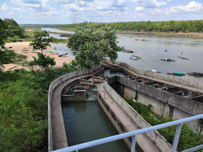
เขื่อนปากมูล Pak Mun Dam
![]()
เขื่อนปากมูล เป็นเขื่อนในจังหวัดอุบลราชธานีกั้นแม่น้ำมูล อยู่ห่างจากลำน้ำมูลและน้ำโขงไปทางตะวันตกประมาณ 5.5 กิโลเมตร ก่อสร้างโดยการไฟฟ้าฝ่ายผลิตแห่งประเทศไทย โดยได้รับการสนับสนุนจากธนาคารโลก โดยมีค่าก่อสร้างทั้งสิ้น 240 ล้านดอลลาร์สหรัฐ สร้างเสร็จในปี พ.ศ. 2537 ในเมื่อ 2510 สำนักงานพลังงานแห่งชาติ หรือปัจจุบันคือ กรมพัฒนาและส่งเสริมพลังงาน (พพ.) มีดำริที่จะพัฒนาแหล่งน้ำแหล่งนี้ โดยได้รับความร่วมจากรัฐบาลฝรั่งเศส ได้ทำการสำรวจและศึกษาโครงการพัฒนาลุ่มแม่น้ำมูลตอนล่าง และกำหนดที่ตั้งตัวเขื่อนไว้ที่บริเวณแก่งตะนะ ซึ่งห่างจากปากแม่น้ำขึ้นมา 4 กิโลเมตร
![]()
เมื่อปี 2522 การไฟฟ้าฝ่ายผลิตแห่งประเทศไทย (กฟผ.) ก็ได้รับโครงการนี้ไปดำเนินการต่อ และได้ศึกษาเพิ่มเติมก็รู้ว่าประโยชน์ที่จะได้รับนั้นคุ้มค่า แต่ผลดระทบที่สำคัญของโครงการนี้คือ การโยกย้ายที่อยู่ของประชากรในแถบนั้นถึง 4,000 หลังคาเรือน ทำให้ต้องชะลอโครงการไว้ก่อน ในปี 2528 การไฟฟ้าฝ่ายผลิตแห่งประเทศไทย (กฟผ.) ได้มีการทบทวนโครงการอีกครั้ง โดยย้ายที่ตั้งตัวเขื่อนมาทางเหนือน้ำประมาณ 1.5 กิโลเมตร และลดระดับการกักเก็บน้ำลง เพื่อให้ประชากรได้รับผลกระทบน้อยที่สุด และผลสรุปในปี 2532 มีประชากรได้รับผลกระทบรวม 903 ราย เป็นผลกระทบต่ออาคารบ้านเรือนรวม 248 หลังคาเรือน ซึ่งลดลงจากปี 2522 เป็นอย่างมาก
![]()
ในภาคอีสานนั้นต้องรับไฟจากส่วนกลาง และต้องซื้อจากการไฟฟ้าของลาวด้วย ทำให้ระบบของภาคอีสานไม่มั่งคงและฟุ่มเฟือย จึงจำเป็นต้องเร่งสร้างแหล่งผลิตไฟฟ้าในภาคอีสานขึ้น เพื่อสร้างความมั่นคงให้กับโรงไฟฟ้าของภาค โครงการนี้จัดอยู่ในแผนการพัฒนาไฟฟ้าของการไฟฟ้าฝ่ายผลิตแห่งประเทศไทย (กฟผ.) ตามแผนพัฒนาเศรษฐกิจและสังคมแห่งชาติฉบับที่ 6 (2530-2340) ซึ่งคณะรัฐมนตรีได้มีมติอนุมัติให้ก่อสร้างโรงไฟฟ้าพลังน้ำเขื่อนปากมูลที่จังหวัดอุบลราชธานี เมื่อวันที่ 15 พฤษภาคม 2533 การไฟฟ้าฝ่ายผลิตแห่งประเทศไทย (กฟผ.) ได้เริ่มดำเนินการก่อสร้างในเดือนมิถุนายน 2533 และเสร็จสมบูรณ์ในเดือนพฤศจิกายน 2537 ตามกำหนดการที่ตั้งไว้
![]()
![]()
A rock-fill dam blocking Mun River in Ban Hua Heo, Khong Chiam District for benefits in agriculture and electricity generation. It is 17 meters high and 300 meters long. The ridge of the dam can be used as a shortcut from Khong Chiam to Sirindhorn District. In addition, at the end of the dam, visitors can take a boat to see beautiful Mun River converging with Mekong River which is called Songsi River (two-colored river).
![]()
Pak Mul Dam is in Ubon Ratchathani Province. It is located 5.5 km west of Mun River and Mekong River. It was built by the Electricity Generating Authority of Thailand with support of World Bank; completed in 1994. The total cost of construction is US$ 240 million. In 1967, Department of Alternative Energy Development and Efficiency is committed to develop this water source with the cooperation of French government surveyed and studied the Lower Mun River Development Project. Location of the dam was set at Kaeng Tana which is 4 kilometers from the estuary. In 1979, the Electricity Generating Authority of Thailand (EGAT) took over the project. After further study, they found that the benefits are worth it, but the important outcome of this project is the migration of population up to 4,000 homes caused the project to be delayed. In 1985, the Electricity Generating Authority of Thailand (EGAT) reviewed the project again, relocated the dam to about 1.5 kilometers above, and reduced the water retention level so that the population is least affected. In conclusion, in 1989, there were a total of 903 people, 248 houses, affected which was greatly reduced from 1979. In the Northeast, it had to receive electricity from central authority and buy from Laos which makes the system of the northeastern region not stable and extravagant. Therefore, it is necessary to accelerate the construction of power generation sources in the Northeast to create stability for the power plants of the region. This project is in the Electricity Development Plan of the Electricity Generating Authority of Thailand (EGAT) under the 6th National Economic and Social Development Plan (1987-1997). The Cabinet has approved the construction of a hydroelectric dam at Ubon Ratchathani Province on May 15, 1990. Electricity Generating Authority of Thailand (EGAT) began construction in June 1990 and completed in November 1994 as the plan.
![]()
Latitude : 15.282027590395415, Longitude : 105.46822762592458
View Larger Map

View On Google Map
Edit Data
Images
-
เขื่อนปากมูล Pak Mun Dam
-

เขื่อนปากมูล Pak Mun Dam
-

เขื่อนปากมูล Pak Mun Dam
-

เขื่อนปากมูล Pak Mun Dam
-

เขื่อนปากมูล Pak Mun Dam
-

เขื่อนปากมูล Pak Mun Dam