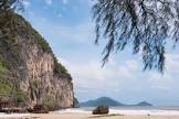
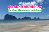
Attraction หาดเจ้าไหม Chao Mai Beach : ตรัง
เป็นอุทยานแห่งชาติทางทะเลครอบคลุมพื้นที่ 2 อำเภอ คือ อำเภอกันตังและอำเภอสิเกา

หาดเจ้าไหม Chao Mai Beach
![]()
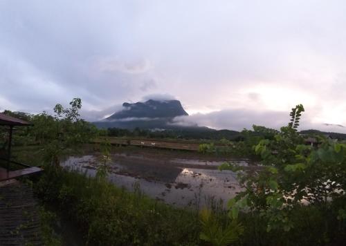
แม้ชื่ออุทยานจะขึ้นต้นด้วยคำว่า "หาด" แต่ที่นี่กลับผนวกทั้งพื้นที่ชายหาดและกลุ่มเกาะมากมายอีกถึง 7 แห่ง ในท้องทะเลอันดามันของจังหวัดตรัง โดยครอบคลุมพื้นที่ 2 อำเภอ คือ อำเภอกันตังและอำเภอสิเกา โดยสามารถแบ่งพื้นที่ออกเป็น 2 ส่วน ได้แก่ พื้นที่ดินสถานที่ท่องเที่ยวของอุทยานฯ ซึ่งก็คือ หาดปากเมง หาดฉางหลาง หาดยาว หาดหยงหลิง หาดสั้น หาดเจ้าไหม ถ้ำเจ้าไหม อีกส่วนหนึ่ง คือ เกาะน้อยใหญ่อีก 7 เกาะในทะเลตรัง ได้แก่ เกาะมุก เกาะกระดาน เกาะเชือก เกาะปลิง เกาะแหวน เกาะเมง และเกาะเจ้าไหม
![]()
สำหรับผู้ที่สนใจเรื่องหญ้าทะเล อยากรู้จักหน้าตาของมันนั้น บริเวณอุทยานฯ ยังมีศูนย์ศึกษาธรรมชาติทางทะเล โดยมุ่งเน้นทำการวิจัยหญ้าทะเลซึ่งมีความสำคัญทางนิเวศวิทยา ของฝั่งทะเลอันดามัน และยังเป็นอาหารของพะยูนที่ใกล้จะสูญพันธุ์แล้วด้วย สถานที่ท่องเที่ยวน่าสนใจในเขตอุทยานหาดเจ้าไหม (Hat Chao Mai National Park) หาดปากเมง (Pak Meng Beach) โดดเด่นด้วยเขาเมง ซึ่งเป็นโขดหินใหญ่กลางน้ำรูปร่างคล้ายคนนอนหงาย หาดเจ้าไหม น้ำตื้นและมีบริเวณกว้าง เหมาะสำหรับเล่นน้ำ เขาเจ้าไหม ภูเขารูปกระโดงปลาฉลาม ถ้ำเจ้าไหม แล่นเรือเข้าไปถึงปากถ้ำได้ ถ้ำเจ้าไหมมีหลายชั้น มีหินงอกหินย้อยสวยงาม เกาะมุก มีถ้ำมรกต สถานที่ท่องเที่ยวยอดนิยมของจังหวัดตรัง (Trang attractions) เกาะเชือก เป็นเกาะเล็ก ๆ 2 เกาะที่อยู่ติดกัน ตลอดแนวชายฝั่งมีแนวปะการังค่อนข้างสมบูรณ์ มีกัลปังหาที่งดงามมาก เกาะกระดาน ตลอดชายฝั่งมีปะการังและกัลปังหานานาชนิด บ่อน้ำร้อน ตั้งอยู่บริเวณตำบลบ่อน้ำร้อน อำเภอกันตัง น้ำในบ่อมีอุณหภูมิราว 70 องศาเซลเซียส เขาแบนะ มีภาพเขียนสีแดงยุคก่อนประวัติศาสตร์ หาดหยงหลิง เป็นหาดทรายรูปโค้ง ด้านหนึ่งติดกับภูเขา
![]()
![]()
This area, which was proclaimed a marine national park on 14 October 1982, covers the 2 districts of Kantang and Sikao. The park headquarters is situated at Chang Lang Beach in Tambon Mai Fat, approximately 47 kilometres from the City.
![]()
Hat Chao Mai national park is comprised of Beaches and 7 islands located on the Andaman Sea in Trang Province. The whole area covers two districts, namely Kun Tung District and Si Kao District. The National Park is subdivided into two areas. The first area is a famous tourist attraction covering Pak Meng Beach, Yao Beach, Yao Beach, Yong Ling Beach, San Beach, Chao Mai Beach, while the second one occupies 7 islands in Trang Province, namely Koh Muk, Koh Kradan, Koh Chueak, Koh Pling, Koh Waen, Koh Meng, and Koh Chao Mai. For those interested in and wanting to learn about sea grass, located in the park is an institute for sea research focusing on conducting research on sea grass. These flowering plants are integral to the whole ecosystem of the Andaman Sea and are a source of food for dugongs, marine mammals that are on the verge of extinction. Interesting Tourist Attractions in Hat Chao Mai National Park Pak Meng Beach is famous for the Meng Rock Mountain in the shape of a human being sleeping with a turning face up Hat Chao Mai is a shallow water beach suitable for water activities. Kao Chao Mai is a mountain in the shape of shark fin. Chao Mai Cave is where tourists are able to sail into the mouth of the multi-layered cave to enjoy stalactites Situated in Koh Muk is an emerald cave, a famous destination in Trang Province. Koh Cheauk is two small adjacent islands where tourists can enjoy breathtaking coral reefs Koh Kradan is another destination where tourists can enjoy a variety of reefs. The famous hot fountain is situated in Kun Tung District. The water temperature can rise to a maximum of about 70 degrees Celsius Kao Bae Na is a mountain where tourists can enjoy prehistoric paintings. Long Ying Beach is in the shape of a crescent, with one side attached to a mountain.
![]()
Latitude : 7.427703678579047, Longitude : 99.34599699733289
View Larger Map

View On Google Map
Edit Data
Images
-
หาดเจ้าไหม Chao Mai Beach
-

หาดเจ้าไหม Chao Mai Beach
-
หาดเจ้าไหม Chao Mai Beach
-

หาดเจ้าไหม Chao Mai Beach
-
หาดเจ้าไหม Chao Mai Beach
-

หาดเจ้าไหม Chao Mai Beach