Attraction อุทยานแห่งชาติน้ำตกสี่ขีด Namtok Si Khit National Park : นครศรีธรรมราช
ยอดเขาคีโหมดเป็นยอดเขาที่สูงที่สุด สูง 1,303 เมตร ปกคลุมด้วยป่าดิบชื้นมีระบบนิเวศน์ที่สมบูรณ์ มีพรรณไม้ที่พบ ได้แก่ ไม้ในวงศ์ไม้ยาง ตะเคียนทอง หลุมพอ จำปาป่า สัตว์ป่าก็มีชุกชุม เช่น สมเสร็จ เลียงผา นกประจำถิ่นภาคใต้ที่หายาก อากาศค่อนข้างเย็นสบาย จะมีฝนตกชุกเดือนพฤศจิกายน

อุทยานแห่งชาติน้ำตกสี่ขีด Namtok Si Khit National Park
![]()
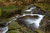
เพราะพื้นที่ส่วนหนึ่งเป็นเทือกเขาหินปูนจึงก่อให้เกิดน้ำตกหินปูนที่สวยงาม และนั่นคือน้ำตกสี่ขีด ไฮไลท์ของอุทยานแห่งชาติน้ำตกสี่ขีดนั่นเอง น้ำตกสายนี้ตั้งอยู่ท่ามกลางธรรมชาติอันร่มรื่น โดดเด่นด้วยธารน้ำสีเขียวมรกตที่มาพร้อมแอ่งน้ำกว้างใหญ่หลายแห่งที่สามารถลงเล่นน้ำได้ และด้วยสภาพส่วนใหญ่เป็นหินปูน ตะไคร่น้ำจึงไม่จับ ทำให้ช่วยลดอันตรายจากการลื่นล้มได้ กล่าวสำหรับอุทยานแห่งชาติน้ำตกสี่ขีดนั้นตั้งอยู่ในแนวทิวเขานครศรีธรรมราชที่สูงชันสลับซับซ้อน มีสันปันน้ำเป็นแนวแบ่งเขตระหว่างจังหวัดนครศรีธรรมราชและสุราษฎร์ธานี และมียอดเขาคีโหมดเป็นยอดเขาที่สูงที่สุด โดยมีความสูง 1,303 เมตรจากระดับทะเลปานกลาง สถานที่ท่องเที่ยวในอุทยานฯ น้ำตกสี่ขีด บริเวณคลองท่าโคก เป็นน้ำตกเกิดจากเขาหินปูน ธารน้ำมีสีเขียวมรกต มีแอ่งน้ำกว้าง สามารถลงเล่นน้ำได้ บริเวณน้ำตกสวยงาม ร่มรื่น ถ้ำเขาพับผ้า ห่างจากที่ทำการอุทยานฯ 5 กิโลเมตร เป็นถ้ำขนาดเล็กที่มีหินงอกหินย้อย สวยงามมาก มีความลึกจากปากถ้ำ 50 เมตร ในถ้ำเป็นที่อยู่อาศัยของสัตว์ชนิดหนึ่ง คือ กง (จงโคร่ง) ขนาดใหญ่
![]()
การเข้าไปชมควรมีเจ้าหน้าที่นำทางอุทยาน
![]()
![]()
Si Khit Waterfall One of the attractions within the premises of Nam Tok Si Khit national park is Si Khit waterfall. It is situated near KlongThaKhok canal or 15 kilometres away from Sichol district, Nakhon Si Thammarat province. The source of the waterfall is sprung from a high mountain range standing at the border between Sichol district in Nakhon Si Thammarat province and Kanjanadit district in Surat Thani province. That area is locally known as Chong Num Pan Gun (Watershred Channel). The water runs from a 60-meter high stone cliff through multiple layers of rock for 12 kilometres. As per the number of tiers belonging to this waterfall, it has not been officially observed yet. However, it is estimated that there might be at least 100 tiers altogether. The flowing manner of the waterfall makes the areas look similar to islands (surrounded by water). It is also said that Si Khit waterfall is equivalent to Erawan waterfall in Kanchanaburi province. The peculiar characteristic of the rocky bottom of this waterfall is that there is no lichens growing on the limestone. Thus, very rare is the report of accidents caused by tripping or slipping. Some limestone developed into magnificent stalagmites and stalactites. There are several large basins with turquoise green water in which visitor can swim. To get there by car: - Starting from Nakhon Si Thammarat, tourists can reach there via Asia National Road (Nakhon Si Thammarat -SuratThani) No. 104. Drive for 69 kilometres, you will find the Ton Payom intersection where its right junction takes you to Sichol district. Make a left turn and continue for 15 kilometers to goto the office of Nam Tok Si khit National Park. - Starting from SuratThani, drive along Highway 401 for about 52 kilometres. At the Khao Hua Chang T-section, turn right and continue for 10 kilometers.
![]()
Latitude : 9.014414591704321, Longitude : 99.77251919733243
View Larger Map

View On Google Map
Edit Data
Images
-
อุทยานแห่งชาติน้ำตกสี่ขีด Namtok Si Khit National Park
-

อุทยานแห่งชาติน้ำตกสี่ขีด Namtok Si Khit National Park
-
อุทยานแห่งชาติน้ำตกสี่ขีด Namtok Si Khit National Park
-

อุทยานแห่งชาติน้ำตกสี่ขีด Namtok Si Khit National Park
-

อุทยานแห่งชาติน้ำตกสี่ขีด Namtok Si Khit National Park
-

อุทยานแห่งชาติน้ำตกสี่ขีด Namtok Si Khit National Park