Attraction วนอุทยานแห่งชาติน้ำตกชีโป Namtok Sipo National Park : นราธิวาส
อุทยานแห่งชาติน้ำตกซีโป มีเนื้อที่ประมาณ 180,518 ไร่ หรือ 288.83 ตารางกิโลเมตร ครอบคลุมพื้นที่ในท้องที่ตำบลดุซงญอ ตำบลกาลิซา ตำบลเฉลิม ตำบลมะรือโบตก ตำบลตะมะยูง ตำบลซากอ ตำบลศรีบรรพต ตำบลเชิงคีรี อำเภอจะนะ อำเภอระแงะ อำเภอรือเสาะ อำเภอศรีสาคร จังหวัดนราธิวาส ลักษณะภูมิประเทศเป็นเทือกเขาสูงสลับซับซ้อนเรียงตัวจากทิศเหนือถึงทิศใต้ มียอดเขาแมะแต เป็นยอดเขาสูงสุดของอุทยานฯ สภาพป่าไม้ในพื้นที่ยังอุดมสมภูรณ์อยู่มากส่วนใหญ่เป็นป่าดงดิบชื้น
วนอุทยานแห่งชาติน้ำตกชีโป Namtok Sipo National Park
![]()
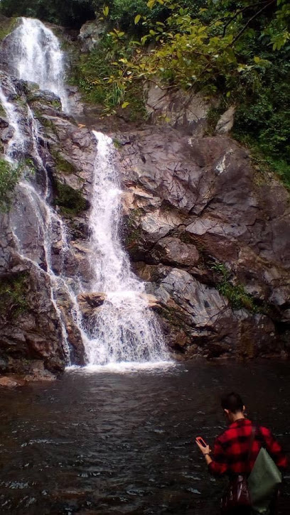
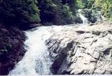
เป็นน้ำตกขนาดใหญ่ มี 7 ชั้น ชั้นที่ 7 เป็นชั้นที่สวยงามที่สุด สายน้ำแผ่กว้างสวยงาม อาบเต็มหน้าผาสูงประมาณ 30 เมตร ตกลงสู่แอ่งน้ำเบื้องล่าง ซึ่งสามารถเล่นน้ำได้ น้ำตกซีโปเป็นต้นน้ำของลำห้วยที่ชาวบ้านนำไปใช้ปลูกลองกองรสดี น้ำตกชั้นแรกอยู่ไม่ไกลจากที่ทำการอุทยานแห่งชาติ มีแอ่งน้ำกว้างที่เกิดจากการสร้างฝายกั้นน้ำ จากที่ทำการอุทยานแห่งชาติมีทางเดินขึ้นสู่น้ำตกชั้นต่าง ๆ
![]()
![]()
Sipo Waterfall National Park, with an area of approximately 180,518 rais or 288.83 square kilometers, covers the local areas of Dusong Yo Subdistrict, Kalisa Subdistrict, Chalerm Subdistrict, Marue Bo Tok Subdistrict, Tamayung Subdistrict, Sako Subdistrict, Si Banphot Subdistrict, Choeng Khiri Subdistrict, Chana District, Rangae District, Rue Sao District, Si Sakorn District, Narathi Province. Vassa topography is a complex of high mountains arranged from north to south, with the peak of Mae Tae being the highest peak in the park. The forest conditions in the area are still very exuberant, with most evergreen forest.
![]()
It is a large waterfall with 7 levels, the 7th level being the most beautiful. The river spreads beautifully. Bathed in a cliff about 30 meters high, falling into a basin below. which can play in the water Si Po Waterfall is the source of the creek that villagers use to grow Longkong RosDee. The first waterfall is not far from the National Park Office. There is a wide basin caused by the construction of a dam. From the National Park Office, there is a path leading up to the different levels of the waterfall.
![]()
Latitude : 6.269702001474718, Longitude : 101.63380999733877
View Larger Map

View On Google Map
Edit Data
Images
-
วนอุทยานแห่งชาติน้ำตกชีโป Namtok Sipo National Park
-

วนอุทยานแห่งชาติน้ำตกชีโป Namtok Sipo National Park
-
วนอุทยานแห่งชาติน้ำตกชีโป Namtok Sipo National Park
-

วนอุทยานแห่งชาติน้ำตกชีโป Namtok Sipo National Park
-

วนอุทยานแห่งชาติน้ำตกชีโป Namtok Sipo National Park
-

วนอุทยานแห่งชาติน้ำตกชีโป Namtok Sipo National Park