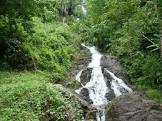
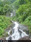
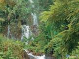
Attraction น้ำตกชุมแสง Chumsaeng Waterfall : ระนอง
น้ำตกชุมแสงหรือน้ำตกสายรุ้ง ตั้งอยู่ที่บ้านปากจั่น ตำบลปากจั่น ห่างจากเขตเทศบาลเมืองระนองและตัวอำเภอกระบุรีไปตามทางหลวง หมายเลข 4 (ไปทางจังหวัดชุมพร) เป็นระยะทาง 80 และ 16 กิโลเมตรตามลำดับ บริเวณหลักกิโลเมตร ที่ 529-530 (ด้านตรงข้ามกับทางเข้าสู่นิคมสร้างตนเองบ้านปากจั่น) จะมีทางแยกซ้ายมือเป็นถนนลูกรัง เข้าไปอีก 3 กิโลเมตร ก็จะถึงบริเวณน้ำตกชุมแสง ซึ่งมีน้ำไหลเฉพาะในฤดูฝน น้ำจะไหลกระแทกกับโขดหิน แล้วกระจายออกเป็นสายดูคล้ายสายรุ้ง จึงทำให้ชาวบ้านมักจะเรียกน้ำตกแห่งนี้ว่า "น้ำตกสายรุ้ง"
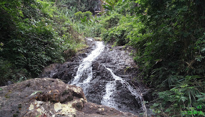
น้ำตกชุมแสง Chumsaeng Waterfall
![]()
![]()
Ranong is known as "the valley town" due to mountainous terrain in the province. Besides, biodiverse forest is found on mountains resulting in a large amount of groundwater under these mountains. Water then flows down from the upland, creating streams and several waterfalls. Ranong has a lot of beautiful waterfalls which can be seen afar. The areas around those falls are perfect places for relaxation and picnic. One of the province's famous waterfalls is Chumsaeng Waterfall, also known as Sai Rung Waterfall by locals. It is located in Ban Pak Chan, Pak Chan Subdistrict, about 80 and 16 kilometres by Chumphon-bound Highway 4 from Ranong Town and Kra Buri Town respectively. Chumsaeng Waterfall is a small waterfall, formerly known as Pak Wip Waterfall. Water flows down a 60-metre-high and 20-metre-wide cliff. During the wet season, the fall has a large volume of water while there is little water in the dry season. The fall, however, looks exquisite all year round. In addition, swimming is allowed in the waterfall lake. However, as it is relatively deep, visitors are recommended to be very careful. Furthermore, there is a trail leading to the top of the fall, along which you will find numerous kinds of trees such as Hopea odorata and White Seraya trees and understory like ferns and rattan palms. The name Sai Rung Waterfall, literally meaning Rainbow Waterfall, is derived from the waterfall itself. Water flows down the cliff and after hitting stones, it is divided into various flows of water. When sunlight hits these flows of water, they resemble rainbows.
![]()
Latitude : 10.499678443325056, Longitude : 98.88350299735336
View Larger Map

View On Google Map
Edit Data
Images
-
น้ำตกชุมแสง Chumsaeng Waterfall
-

น้ำตกชุมแสง Chumsaeng Waterfall
-
น้ำตกชุมแสง Chumsaeng Waterfall
-
น้ำตกชุมแสง Chumsaeng Waterfall
-

น้ำตกชุมแสง Chumsaeng Waterfall
-
น้ำตกชุมแสง Chumsaeng Waterfall