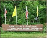
Attraction อุทยานแห่งชาติแก่งกรุง Kaeng Krung National Park : สุราษฎร์ธานี
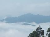
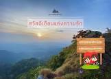
ข้อมูลทั่วไป แก่งกรุง เป็นชื่อแก่งขนาดใหญ่ในลำน้ำคลองยัน ในอดีตการไฟฟ้าฝ่ายผลิตแห่งประเทศไทยดำเนินการสำรวจเพื่อก่อสร้างเขื่อนอเนกประสงค์ ปัจจุบันได้ชะลอโครงการดังกล่าวไว้ อุทยานแห่งชาติแก่งกรุง ตั้งอยู่ในพื้นที่จังหวัดสุราษฎร์ธานี ครอบคลุมพื้นที่อำเภอท่าชนะ อำเภอไชยา อำเภอท่าฉาง กิ่งอำเภอวิภาวดี เป็นอุทยานที่มีสภาพป่าเป็นเทือกเขาสลับซับซ้อน มีสถานที่น่ารื่นรมย์สำหรับพักผ่อนหย่อนใจ เช่น น้ำตก ลำน้ำ บ่อน้ำร้อน ภูเขา ซึ่งมีทัศนียภาพที่สวยงาม เป็นป่าต้นน้ำลำธารที่หล่อเลี้ยงชาวจังหวัดสุราษฎร์ธานีและจังหวัดชุมพร มีเนื้อที่ประมาณ 338,125 ไร่ หรือ 541 ตารางกิโลเมตร ความเป็นมา : จากการที่การไฟฟ้าฝ่ายผลิตแห่งประเทศไทย ได้มีโครงการสร้างเขื่อนแก่งกรุง บริเวณที่ดินป่าท่าชนะ อันจะก่อให้เกิดปัญหาบุกรุกพื้นที่รอบอ่างเก็บน้ำ และกรมป่าไม้ได้มีคำสั่งที่ 1169/2532 ลงวันที่ 31 กรกฎาคม 2532 ให้ นายเดชาวุธ เศรษฐพรรค์ นักวิชาการป่าไม้ 5 ไปสำรวจพื้นที่เพื่อเก็บข้อมูลเบื้องต้น บริเวณพื้นที่อ่างเก็บน้ำแก่งกรุง และพื้นที่ป่าในเขตป่าสงวนแห่งชาติท่าชนะ และป่าเตรียมการสงวนคลองสก-คลองแสง-คลองยัน ในท้องที่จังหวัดสุราษฎร์ธานี ปรากฏว่าบริเวณดังกล่าว เป็นป่าดิบชื้นที่อุดมสมบูรณ์มากประกอบด้วยพันธุ์ไม้มีค่าหลายชนิดอย่างหนาแน่น มีสัตว์ป่าชุกชุม และนกนานาชนิด นอกจากนี้ยังมีจุดเด่นทางธรรมชาติที่สวยงามและสำคัญยิ่ง คือ ป่าส่วนนี้เป็นแหล่งต้นน้ำลำธารที่หล่อเลี้ยงชาวจังหวัดสุราษฎร์ธานี และจังหวัดชุมพร ต่อมากรมป่าไม้ได้มีคำสั่งที่ 892/2532 ลงวันที่ 24 พฤศจิกายน 2532 ให้ นายเดชาวุธ เศรษฐพรรค์ ไปดำเนินการสำรวจข้อมูลเพิ่มเติม และจัดตั้งพื้นที่ป่าสงวนแห่งชาติป่าท่าชนะ และป่าเตรียมการสงวนคลองสก-คลองแสง-คลองยัน ท้องที่จังหวัดสุราษฎร์ธานี ให้เป็นอุทยานแห่งชาติ กองอุทยานแห่งชาติ ได้รับรายงานจาก นายเดชาวุธ เศรษฐพรรค์ ตามหนังสือ ที่ กษ 0713/พิเศษ ลงวันที่ 26 ธันวาคม 2532 เห็นสมควรใช้ชื่ออุทยานแห่งนี้ว่า “อุทยานแห่งชาติคลองยัน” เนื่องจากเป็นคลองสำคัญและเป็นจุดเด่นในพื้นที่ แต่กองอุทยานแห่งชาติได้พิจารณาเห็นว่า เนื่องจากพื้นที่ดังกล่าวรัฐบาลมีโครงการสร้างเขื่อนแก่งกรุง ประกอบกับชื่อแก่งกรุง เป็นที่รู้จักกันแพร่หลาย จึงเห็นสมควรใช้ชื่ออุทยานแห่งนี้ว่า “อุทยานแห่งชาติแก่งกรุง” กรมป่าไม้จึงได้เสนอคณะกรรมการอุทยานแห่งชาติ ครั้งที่ 1/2533 เห็นสมควรให้ดำเนินการตราพระราชกฤษฎีกา กำหนดพื้นที่ป่าท่าชนะ ในท้องที่ ตำบลคันธุลี ตำบลคลองพา ตำบลสมอทอง ตำบลประสงค์ อำเภอท่าชนะ ตำบลปากหมาก อำเภอไชยา ตำบลปากฉลุย และตำบลตะกุกเหนือ อำเภอคีรีรัฐนิคม จังหวัดสุราษฎร์ธานี ให้เป็นอุทยานแห่งชาติ เมื่อวันที่ 4 ธันวาคม 2534 ได้ลงประกาศในราชกิจจานุเบกษา เล่มที่ 108 ตอนที่ 211 เป็นอุทยานแห่งชาติลำดับที่ 69 ของประเทศ ลักษณะภูมิประเทศ ลักษณะภูมิประเทศเป็นเทือกเขาสลับซับซ้อนสองแนวเหนือ-ใต้ ประกอบด้วย เขาไฝ เขาแดน เขายายหม่อน มียอดเขาสูงสุดประมาณ 849 เมตรจากระดับน้ำทะเล ส่วนใหญ่เป็นพื้นที่มีลักษณะเป็นเขาดิน แร่ที่สำคัญที่มีอยู่บริเวณนี้คือ แร่ดีบุก เป็นแหล่งต้นน้ำสำคัญคือ ลำน้ำคลองยัน ต้นแม่น้ำตาปีทางทิศใต้ และลำน้ำคลองสระ ต้นแม่น้ำหลังสวนด้านทิศเหนือ ซึ่งประกอบด้วยคลองและลำห้วยเล็กๆ มากมาย ได้แก่ คลองสระ คลองชง ห้วยลาชี ห้วยหินโล่ ห้วยเขาแดน ห้วยปลาย ห้วยป่าหมาก และคลองยัน ลักษณะภูมิอากาศ สภาพโดยทั่วไปเป็นป่าดิบชื้น จึงทำให้มีฝนตกเกือบตลอดทั้งปีและมีอากาศค่อนข้างเย็น พืชพรรณและสัตว์ป่า เนื่องจากอุทยานแห่งชาติแก่งกรุง มีภูมิประเทศเป็นเทือกเขาสลับซับซ้อนมีปริมาณฝนตกชุก ทำให้คลุมไปด้วยป่าดิบชื้น พันธุ์ไม้ที่พบมากมายทั้งประเภทไม้ยืนต้นขนาดใหญ่ ซึ่งมีค่าทางเศรษฐกิจและน่าศึกษาค้นคว้าทางวิชาการ รวมถึงเป็นที่อยู่อาศัยของสัตว์ป่ามากมาย ไม้ยืนต้นขนาดใหญ่ ขนาดกลาง ขนาดเล็ก ไม้พุ่มพืชพื้นล่างชนิดต่างๆ เถาวัลย์ หวาย และปาล์มขึ้นปะปนกันอย่างหนาแน่นพันธุ์ไม้มีค่าทางเศรษฐกิจที่พบมาก ได้แก่ หลุมพอ จำปา และยางชนิดต่างๆ พืชพื้นล่างพวกเฟิน มีขึ้นทั่วไป รวมทั้งกระโถนพระฤาษี เถาวัลย์ชนิดต่างๆ ทั้งขนาดใหญ่และเล็ก ทำให้สภาพป่าแน่นทึบมากสัตว์ป่าที่อาศัยในอุทยานแห่งชาติแก่งกรุง ได้แก่ ช้างป่า เสือโคร่ง หมี กระทิง วัวแดง สมเสร็จ ชะนี ลิง ค่าง เก้ง กวางป่า หมูป่า ลิงเสน ค่างดำ นกปรอด นกชนหิน นกแซงแซวปากกา นกเขียวคราม และสัตว์อื่นๆ อีกมากมาย รวมทั้งสัตว์เลื้อยคลาน น้ำตกบางจำ อยู่ในตำบลตะกุกเหนือ กิ่งอำเภอวิภาวดี เป็นน้ำตกขนาดกลาง มีน้ำมากเฉพาะในฤดูฝน เกิดจากธารน้ำสายเล็กสายน้อยที่พาดผ่านหุบเขาในหมู่บ้าน แล้วไหลรวมกันเป็นคลองขนาดย่อม แล้วโจนลงจากหน้าผาหินสู่หุบเขาเบื้องล่าง ก่อนที่จะไหลไปรวมกับคลองยันบริเวณเชี่ยวบางจำ กิจกรรม -เดินป่าศึกษาธรรมชาติ - เที่ยวน้ำตก น้ำตกคลองพา อยู่ในตำบลคลองพา อำเภอท่าชนะ เป็นน้ำตกขนาดกลาง มี 7 ชั้น มีน้ำมากตลอดปี กิจกรรม -เที่ยวน้ำตก บ่อน้ำร้อน อยู่ในตำบลตะกุกเหนือ กิ่งอำเภอวิภาวดี เป็นลานกว้าง มีตาน้ำผุดขึ้นมาจากพื้นดิน มีอุณหภูมิของน้ำประมาณ 40องศาเซลเซียส อบอวลด้วยกลิ่นกำมะถัน บริเวณรอบบ่อเป็นดินโป่งขนาดใหญ่ มีพื้นที่ประมาณ 2 ไร่ มีโอกาสพบเห็นสัตว์ป่าหลายชนิดลงมากินโป่งน้ำพุร้อน กิจกรรม -เดินป่าศึกษาธรรมชาติ - ส่องสัตว์ ลำน้ำคลองยัน อยู่ในตำบลตะกุกเหนือ กิ่งอำเภอวิภาวดี เป็นลำน้ำที่มีเกาะแก่งและธรรมชาติของป่าดิบชื้นริมสองฝั่งน้ำสวยงาม สามารถล่องแก่งได้ตลอดทั้งปี โดยเริ่มต้นจากตำบลปากหมาก อำเภอไชยา ผ่านเชี่ยวบางจำ เชี่ยวแก่งกรุง สายน้ำจะลดความรุนแรงลงให้ได้ชมความงามของธรรมชาติสองฟากฝั่ง และมาสิ้นสุดที่ตำบลตะกุกเหนือ หน้ากิ่งอำเภอวิภาวดี กิจกรรม -ล่องแก่ง ลำน้ำคลองสระ เป็นอีกลำน้ำซึ่งสามารถล่องแก่งได้อย่างเพลิดเพลิน และตื่นเต้นตลอดเส้นทาง กิจกรรม -ล่องแก่ง ผาหนุมาน อยู่บนยอดเขาบางจำ สูงจากระดับน้ำทะเลประมาณ 700-800 เมตร เป็นจุดชมทะเลหมอกและทิวทัศน์ของปาดิบชื้นเทือกเขาบรรทัด สถานที่ติดต่อ อุทยานแห่งชาติแก่งกรุง ตู้ ปณ. 93 อ. กิ่งอำเภอวิภาวดี จ. สุราษฏร์ธานี 84000โทรศัพท์ 0 6274 7208, 0 1438 0962 การเดินทางรถยนต์ จากกรุงเทพฯ - สุราษฎร์ธานี ระยะทางประมาณ 700 กิโลเมตร จาก สุราษฎร์ธานี - อำเภอท่าชนะ ระยะทาง 120 กิโลเมตร จากนั้นแยกซ้ายเข้าบ้านคันธุลี ระยะทางประมาณ 25 กิโลเมตร ถึงที่ทำการอุทยานแห่งชาติ

อุทยานแห่งชาติแก่งกรุง Kaeng Krung National Park
![]()
![]()
General Information Kang Krung National Park, in Thachana District, Chaiya District, Thachang District, and Wipawadi District, Surat Thani Province, consists of forest and complicated mountain range which is the source of rivers for people in Surat Thani Province and Chumpon province, and has many nice places suitable for recreation such as waterfalls, streams, hot-water pond and mountains. The area has beautiful sceneries, and is about 541 squares kilometers or 338,125 Rai. The Royal Forest Department has proclaimed it to be a national park on December 4, 1990.The area consists of two-complicated mountain ranges lying north and south. A valley between two mountain ranges is the source of Luangsuan River in the north, and Klongyan Canal in the south. The highest mountain is 849 meters above sea level. Most of the area is soil-mountain which has tin be an important and valuable mineral. Climate Most of the area is rain forest so that causes rain all the year round and the temperature is quite cold. Flora and Fauna There are economically valuable plants such as Lumpor (a kind of Leguminosae), champak and many kinds of Yang. The lower plants are, generally, fern and many kinds of climber which make the area is thick forest. The animals found are wild elephant, tiger, bear, seladang, banteng, tapir, gibbon, monkey, langur, barking deer, deer, wild boar, stump-tailed monkey, banned langur, amphibian, and many kinds of bird such as bulbul, helmeted hornbill, crow-billed drongo, Asian fairy-bluebird. Banghoy Waterfall Banghoy Waterfall, in Banghoy Sub-district, Thachang District, is a three-level waterfall which has water all year round. Bang Cham Waterfall Bang Jum Waterfall, in Takooknuar Sub-district, Wipawadee Sub-amphur, is a medium-size waterfall which has much water in rainy season. Nam Tok Klong-Pa Klong-Pa Waterfall, in Klong-Pa Sub-district, Thachana District, is a medium-size and seven-level waterfall, and has much water all the year round Hot Water Pond Hot Water Pond, in Takooknuar Sub-district, Wipawadee Sub-amphur, is surrounded by big salt-lick area about two Rais (3200 sq-m.). There are many wild animals come to eat its salt-lick hot spring. Klongyan River Klongyan River, in Takooknuar Sub-district, Wipawadee Sub-amphur, is a river which has many islands and islets. There are beautiful sceneries of rain forest along both sides of the river so that is suitable for going down the river by raft all the year round. Klongsa River Klongsa River is also a river which traveler can enjoy going excitedly down the river by raft. Contact Address Kaeng Krung National ParkMu 7, Takuk Nuar Sub-district, Amphur King Amphoe Wiphawadi Surat Thani Thailand 84000Tel. 0 6274 7208, 0 1438 0962 How to go? By Car Going 700 kilometers from Bangkok to Surat Thani Province, and 120 kilometers from Surath Thani Province to Thachana District, then go on 35 kilometers on tarmac road and 9 kilometers on laterite road to Kang Krung National Park Office.
![]()
![]()
General Information Kang Krung National Park, in Thachana District, Chaiya District, Thachang District, and Wipawadi District, Surat Thani Province, consists of forest and complicated mountain range which is the source of rivers for people in Surat Thani Province and Chumpon province, and has many nice places suitable for recreation such as waterfalls, streams, hot-water pond and mountains. The area has beautiful sceneries, and is about 541 squares kilometers or 338,125 Rai. The Royal Forest Department has proclaimed it to be a national park on December 4, 1990.The area consists of two-complicated mountain ranges lying north and south. A valley between two mountain ranges is the source of Luangsuan River in the north, and Klongyan Canal in the south. The highest mountain is 849 meters above sea level. Most of the area is soil-mountain which has tin be an important and valuable mineral.
![]()
![]()
Climate Most of the area is rain forest so that causes rain all the year round and the temperature is quite cold.
![]()
![]()
Flora and Fauna There are economically valuable plants such as Lumpor (a kind of Leguminosae), champak and many kinds of Yang. The lower plants are, generally, fern and many kinds of climber which make the area is thick forest. The animals found are wild elephant, tiger, bear, seladang, banteng, tapir, gibbon, monkey, langur, barking deer, deer, wild boar, stump-tailed monkey, banned langur, amphibian, and many kinds of bird such as bulbul, helmeted hornbill, crow-billed drongo, Asian fairy-bluebird.
![]()
![]()
Banghoy Waterfall Banghoy Waterfall, in Banghoy Sub-district, Thachang District, is a three-level waterfall which has water all year round.
![]()
![]()
Bang Cham Waterfall Bang Jum Waterfall, in Takooknuar Sub-district, Wipawadee Sub-amphur, is a medium-size waterfall which has much water in rainy season.
![]()
![]()
Nam Tok Klong-Pa Klong-Pa Waterfall, in Klong-Pa Sub-district, Thachana District, is a medium-size and seven-level waterfall, and has much water all the year round
![]()
![]()
Hot Water Pond Hot Water Pond, in Takooknuar Sub-district, Wipawadee Sub-amphur, is surrounded by big salt-lick area about two Rais (3200 sq-m.). There are many wild animals come to eat its salt-lick hot spring.
![]()
![]()
Klongyan River Klongyan River, in Takooknuar Sub-district, Wipawadee Sub-amphur, is a river which has many islands and islets. There are beautiful sceneries of rain forest along both sides of the river so that is suitable for going down the river by raft all the year round.
![]()
![]()
Klongsa River Klongsa River is also a river which traveler can enjoy going excitedly down the river by raft.
![]()
![]()
Contact Address Kaeng Krung National ParkMu 7, Takuk Nuar Sub-district, Amphur King Amphoe Wiphawadi Surat Thani Thailand 84000Tel. 0 6274 7208, 0 1438 0962
![]()
![]()
How to go? By Car Going 700 kilometers from Bangkok to Surat Thani Province, and 120 kilometers from Surath Thani Province to Thachana District, then go on 35 kilometers on tarmac road and 9 kilometers on laterite road to Kang Krung National Park Office.
![]()
![]()
![]()
![]()
![]()
![]()
Latitude : 9.307958680906603, Longitude : 98.86607172618419
View Larger Map

View On Google Map
Edit Data
Images
-
อุทยานแห่งชาติแก่งกรุง Kaeng Krung National Park
-
อุทยานแห่งชาติแก่งกรุง Kaeng Krung National Park
-
อุทยานแห่งชาติแก่งกรุง Kaeng Krung National Park
-
อุทยานแห่งชาติแก่งกรุง Kaeng Krung National Park
-

อุทยานแห่งชาติแก่งกรุง Kaeng Krung National Park
-

อุทยานแห่งชาติแก่งกรุง Kaeng Krung National Park