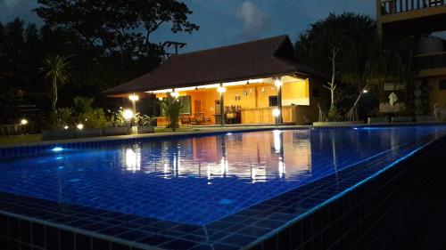
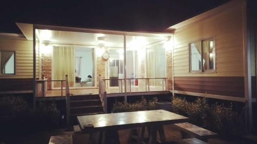
Attraction อุทยานแห่งชาติศรีน่าน Si Nan National Park : น่าน
ลักษณะภูมิประเทศ ลักษณะภูมิประเทศเป็นเทือกเขาสลับซับซ้อน แนวเขาวางตัวในทิศเหนือ-ใต้เทือกเขาที่สำคัญคือ ดอยแปรเมือง ดอยขุนห้วยฮึก ขุนห้วยหญ้าไทร และดอยหลวง มียอดเขาขุนห้วยฮึก ซึ่งอยู่ทางทิศเหนือของพื้นที่สูงที่สุด มีความสูง 1,234 เมตร จากระดับน้ำทะเลปานกลาง เป็นป่าต้นน้ำลำธารของแม่น้ำน่านทั้งสิ้น ส่วนใหญ่ไหลจากทิศเหนือไปสู่ทิศใต้ แหล่งน้ำที่พบเป็นแหล่งน้ำธรรมชาติ มีลำห้วยลำธารที่สำคัญคือ แม่น้ำขะนิง แม่น้ำสา นอกจากลำน้ำสองสายแล้วยังมีลำห้วยเล็กๆ อีกหลายสาย

อุทยานแห่งชาติศรีน่าน Si Nan National Park
![]()
![]()
ลักษณะภูมิอากาศ ลักษณะภูมิอากาศแบ่งออกเป็นสามฤดู คือ ฤดูร้อน อากาศจะร้อนพอประมาณ เริ่มตั้งแต่เดือนกุมภาพันธ์ถึงเดือนเมษายน ฤดูฝน ฝนจะตกปานกลางถึงหนัก เริ่มตั้งแต่เดือนพฤษภาคมถึงเดือนตุลาคม ฤดูหนาว อากาศจะหนาวจัด เริ่มตั้งแต่เดือนพฤศจิกายนถึงเดือนมกราคม ลักษณะท้องฟ้ามีเมฆมากในฤดูฝนช่วงเดือนกรกฎาคมถึงเดือนกันยายน และมีเมฆน้อยมากในช่วงเดือนมกราคมถึงเดือนมีนาคม อุณหภูมิโดยเฉลี่ยประมาณ 24 องศาเซลเซียส
![]()
![]()
พืชพรรณและสัตว์ป่า เนื่องจากลักษณะภูมิประเทศเป็นเทือกเขาสลับซับซ้อน ประเภทป่าแบ่งออก เป็น 2 ประเภทใหญ่ คือ ป่าไม่ผลัดใบ ได้แก่ ป่าดิบแล้ง ป่าดิบเขา ป่าสนเขา พันธุ์ไม้ที่พบคือ กระบาก ตะเคียน ยาง ประดู่ มะค่าโมง ยมหอม ตะแบก ชิงชัน เหียง พลวงตะเคียนหนู พวกไม้ก่อต่างๆ พลับพลา หมีเหม็น สนสองใบ สนสามใบ เป็นต้น ป่าผลัดใบ ได้แก่ ป่าเบญจพรรณ ป่าเต็งรัง พันธุ์ไม้ที่พบคือ สัก แดง ประดู่ ชิงชัน ขะเจ๊าะ สาธร มะค่าโมง ตะแบก ตีนนก โมกหลวง เต็ง รัง เหียง พลวง ตะคร้อ มะม่วงป่า กว้าว รกฟ้า มะกอก ไผ่ชนิดต่างๆ เป็นต้น สัตว์ป่าที่พบส่วนใหญ่คือ กระทิง วัวแดง กวางป่า หมูป่า หมี เสือโคร่ง เสือดาว ชะนี ลิงลม หมาไน หมาจิ้งจอก กระจง อีเห็น เสือป่า กระต่ายป่า กระแต กระรอก หมาจิ้งจอก นกนานาชนิด ที่สำคัญ คือ นกยูงไทย สัตว์เลื้อยคลานชนิดต่างๆ สัตว์ครึ่งบกครึ่งน้ำ ซึ่งจะพบตามแหล่งน้ำธรรมชาติ
![]()
![]()
เสาดินนาน้อยและคอกเสือ เสาดินนาน้อยมีลักษณะเป็นหุบผาและแท่งดินผสมหินลูกรังสีแดงปนส้มรูปทรงต่างๆ เกิดจากการพังทลายของดินเป็นพื้นที่กว้างประมาณ 60 ไร่ กระจัดกระจายไปตามพื้นที่ โดยมีป่าเต็งรังขึ้นอยู่ประปราย ลักษณะของเสาดินคล้ายแกรนด์แคนยอนเหมือนกับแพะเมืองผีของจังหวัดแพร่ ส่วนคอกเสืออยู่ห่างจากเสาดินนาน้อยประมาณ 300 เมตร ลักษณะเป็นแอ่งลึกประมาณ 10 เมตร มองดูคล้ายหุบผาซึ่งมีแท่งดินตั้งกระจายอยู่ภายใน การเดินทางจากอำเภอนาน้อยใช้ทางหลวงจังหวัดหมายเลข 1083 ไปประมาณ 3 กิโลเมตร มีทางแยกเข้าไปอีก 2 กิโลเมตร กิจกรรม -ชมทิวทัศน์ - เที่ยวถ้ำ/ธรณีวิทยา
![]()
![]()
ปากนาย เกิดจากพื้นที่ป่าที่ถูกน้ำเหนือเขื่อนสิริกิติ์ท่วมถึง มีขนาดกว้างใหญ่ที่สุดในจังหวัดน่าน มีหมู่บ้านชาวประมงน้ำจืดอาศัยอยู่และทิวทัศน์สวยงามด้วยผืนทะเลสาบกว้างและเงียบสงบอยู่ท่ามกลางทิวเขาที่โอบล้อม สามารถนั่งเรือชมทิวทัศน์ของปากนายหรือค้างแรมบนเรือนแพที่ให้บริการ กิจกรรม -ชมทิวทัศน์ - ล่องแพ/ล่องเรือ
![]()
![]()
แก่งหลวง ลักษณะเป็นแก่งหินขนาดใหญ่ขวางกั้นลำน้ำน่านซึ่งถูกโอบล้อมด้วยภูเขาสูงสองด้าน ฤดูน้ำหลากที่กระแสน้ำไหลแรง จะมีเสียงน้ำไหลกระทบโขดหินดังกึกก้อง ฤดูแล้งน้ำน้อยจะมองเห็นแนวหินและโขดหินกระจัดกระจายอย่างสวยงาม ปรากฏหาดทรายสีขาวยาวตลอดริมฝั่ง เหมาะสำหรับการมาท่องเที่ยวพักผ่อนและเล่นน้ำ แก่งหลวงอยู่ริมทางหลวงจังหวัดหมายเลข 1083 ห่างจากที่ทำการอุทยานแห่งชาติประมาณ 17 กิโลเมตร กิจกรรม -ล่องแก่ง - ชมทิวทัศน์
![]()
![]()
ดอยผาชู้ เป็นหน้าผาหินสูงชัน ตั้งตระหง่านอยู่ริมฝั่งแม่น้ำน่าน จากจุดนี้สามารถมองเห็นทิวทัศน์ป่าเขาแม่น้ำน่าน ทอดตัวคดเคี้ยวไปตามที่ราบลุ่มที่อยู่ต่ำกว่า รวมทั้งทะเลหมอกยามเช้าที่งดงาม และเป็นที่ตั้งของที่ทำการอุทยานแห่งชาติศรีน่าน กิจกรรม -ชมทิวทัศน์ - เดินป่าศึกษาธรรมชาติ
![]()
![]()
ทิวทัศน์ทั้งสองฝั่งแม่น้ำน่าน ความยาวกว่า 60 กิโลเมตร มีสภาพป่าไม้ที่อุดมสมบูรณ์ ตลอดจนโขดหิน หน้าผาต่างๆ เป็นทิวทัศน์ที่งดงามเหมาะแก่การล่องแพ และนั่งเรือชมธรรมชาติ
![]()
![]()
สถานที่ติดต่อ อุทยานแห่งชาติศรีน่าน ตู้ ปณ. 14 อ. นาน้อย จ. น่าน 55150 โทรศัพท์ 0 5470 1106 โทรสาร 0 5470 1106
![]()
![]()
การเดินทาง รถยนต์ จากกรุงเทพฯ ผ่านนครสวรรค์ พิษณุโลกถึงแพร่ จากแพร่ตามถนนยันตรกิจโกศล ทางหลวงแผ่นดินหมายเลข 101 ไปถึงอำเภอเวียงสา เลี้ยวขวาไปตามถนนเจ้าฟ้า ทางหลวงจังหวัดหมายเลข 1026 จากอำเภอ เวียงสาไปอำเภอนาน้อย ระยะทางประมาณ 35 กม. แล้วเลี้ยวซ้ายเข้าตามถนนสายนาน้อย -ปางไฮ ทางหลวงจังหวัดหมายเลข 1083 ไปอีกประมาณ 5 กิโลเมตร จะถึงเสาดิน และถึงที่ทำการอุทยานแห่งชาติ
![]()
![]()
สถานที่กางเต็นท์/เต็นท์ มีพื้นที่กางเต็นท์ พร้อมห้องน้ำ-ห้องสุขารวม ไว้ให้บริการ ท่านสามารถนำเต็นท์มากางเอง หรือติดต่อขอใช้บริการเต็นท์ของอุทยานแห่งชาติ ซึ่งมีค่าบริการอยู่หลายอัตราขึ้นอยู่กับชนิด ขนาดของเต็นท์ และอุปกรณ์ประกอบอื่นๆ รายละเอียดเกี่ยวกับที่พักเต็นท์ขอให้ติดต่อสอบถามกับอุทยานแห่งชาติโดยตรง
![]()
![]()
General Information Srinan National Park is situated in an approximate area of 934 square kilometers or 583,750 rai, covering the areas of Na-muen District, Na-noi District, and Vieng-sa District of Nan Province. The geographical features of the National Park consist of high mountains, extending northwards, virgin forests, and major rain forests of Nan River, which are regarded as major water resources of people within Nan Province. The National Park is the dwelling place for a large number of wild animals and having major plants, tourist attractions and beautiful natural sightseeing spots on both sides of Nan River such as Sao-din and Cok-sua, Pak-nai, Kaeng-luang, Pha-choo, etc. The geographical features of the National Park consist of high mountains, extending northwards. Major mountains include Doi Prae-muang, Doi Khun Huai Heuk, Khun Huai Ya-sai, and Doi Luang. Doi Khun Huai Heuk, situated in the northern part of the National Park, is the highest mountaintop (1,234 meters above the medium sea level) and being the source of major gullies, flowing southward into Nan River. The National Park has natural water sources and major gullies including Khaning River, Sa River, as well as other small gullies.
![]()
![]()
Climate The weather at the National Park can be divided into 3 seasons including summer (February-April), when the weather is extremely hot; rainy season (May-October), when it rains moderately to heavily; and winter (November-January), when the weather is extremely cold. There are thick banks of clouds in the rainy season, particularly during July and September and thin banks of clouds during January and March.
![]()
![]()
Flora and Fauna Since the geographical features of the National Park consist of high mountains, there are two major kinds of forests within the area of the National Park, including deciduous forests such as arid, evergreen forests, virgin forests, pinery, of which major plants include Irvingia Malayana Oliv. (Krabok), Anisoptera Costata (Krabak), Malabar Ironwood, rubber trees, teaks, Leguminosae (Pradoo), Afzelia Xylocarpa Roxb., Indian Mahogany, two-leaf pines, three-leaf pines, etc.; and leafy forests such as mixed forests, timber forests, of which major plants include teaks, Xylia Xylocarpa (redwood plants), Leguminosae (Pradoo), Dalbergia Oliveri Gamble (Ching Chan), Millettia Pendula (Ka-jaw), Sathorn, Anogeissus Acuminata Wall. (Takien Noo), Afzelia Xylocarpa Roxb., Lagerstroemia (Tabaek), Vitex Pinnata Linn. (Teen Nok), etc.
![]()
![]()
Wild animals found in the National Park include deer, wild boars, bears, tigers (felis tigris), leopards, gibbons, loris, Asiatic wild dogs, foxes, mouse deer, masked palm civets, fishing cats, rabbits, tree shrews, squirrels, different kinds of birds, reptiles, and amphibians, which can be found in the natural water sources.
![]()
![]()
Sao Din Na Noi and Cok Sua Sao-din originated from soil erosion covering an approximate area of 20 rai and scattered with timber forests. Sao-din looks like the Grand Canyon or Pae-muang-pi of Prae Province.
![]()
![]()
Pak Nai Pak-nai is one of the most beautiful sightseeing spots of the National Park, originating from the largest flooded area above the Sirikit Dam in Nan Province, surrounded by freshwater fishermen villages.
![]()
![]()
Kaeng Luang Kaeng Luang originated from stone lines, rocks, and cliffs along Nan River. In the rainy season, you can hear the roar of streams hitting the rocks. In the dry season, you can see beautiful stone lines and rocks scattering the area.
![]()
![]()
Doi Pha Choo View Point Doi Phachoo is a large, towering cliff where you can overlook the forests and Nan River extending tortuously along the lower plains.
![]()
![]()
Contact Address Si Nan National Park P.O.Box 14 Amphur Na Noi Nan Thailand 55150 Tel. 0 5470 1106 Fax 0 5470 1106
![]()
![]()
How to go? By Car From the city of Bangkok, you may travel through Nakhon Sawan Province and Pitsanulok Province until reaching Prae Province. From Prae Province, take Highway No.1026 (Yantrakijkoson Road) until reaching Vieng-sa District. Then, make a right hand turn and travel along Chaopha Road (Highway No.1026, Viengsa-Nanoi) for approximately 35 km. Then, make a left hand turn to Nanoi-Panghai Road (Highway No.1083) and go straight on for approximately 5 km until reaching Sao-din and the National Park’s office.
![]()
![]()
Latitude : 18.367707911140887, Longitude : 100.83918149067645
View Larger Map

View On Google Map
Edit Data
Images
-
อุทยานแห่งชาติศรีน่าน Si Nan National Park
-

อุทยานแห่งชาติศรีน่าน Si Nan National Park
-

อุทยานแห่งชาติศรีน่าน Si Nan National Park
-

อุทยานแห่งชาติศรีน่าน Si Nan National Park
-

อุทยานแห่งชาติศรีน่าน Si Nan National Park
-

อุทยานแห่งชาติศรีน่าน Si Nan National Park