Attraction อุทยานแห่งชาติแม่ปืม Mae Puem National Park : พะเยา
ลักษณะภูมิประเทศ ส่วนที่ 1 ลักษณะภูมิประเทศส่วนมากจะเป็นภูเขาสูงชัน และมีพื้นที่บนเขาน้อยมาก ความยาวจากทิศเหนือ-ใต้ ประมาณ 27 กิโลเมตร และยังเป็นต้นกำเนิดของลำน้ำแม่แก้วซึ่งตามลำน้ำจะมีลักษณะเป็นโขดหินที่สวยงามและมีน้ำไหลตลอดปี ทิศด้านลาดจะอยู่ทางด้านทิศตะวันออกและตะวันตก จุดที่สูงที่สุดจะอยู่ทางด้านทิศเหนือมีความสูงตั้งแต่ 403-936 เมตรจากระดับน้ำทะเลปานกลาง

อุทยานแห่งชาติแม่ปืม Mae Puem National Park
![]()
![]()
ส่วนที่ 2 ลักษณะภูมิประเทศเป็นแบบภูเขาสูงชันทอดตัวยาวจากทิศเหนือ-ใต้ มีความยาวประมาณ 32 กิโลเมตร ทิศด้านลาดจะอยู่ทางทิศตะวันออกและตะวันตกที่มีราบบนสันเขา ความกว้างโดยเฉลี่ยตลอด แนวกว้างประมาณ 4 กิโลเมตร และเป็นต้นกำเนิดของลำห้วยแม่ปืมซึ่งมีน้ำไหลตลอดปี จุดสูงที่สุดอยู่บริเวณทางด้านทิศเหนือมีความสูงตั้งแต่ 403-978 เมตรจากระดับน้ำทะเลปานกลาง
![]()
![]()
ลักษณะภูมิอากาศ ลักษณะภูมิอากาศของอุทยานแห่งชาติแม่ปืมเป็นแบบมรสุมเขตร้อน โดยได้รับอิทธิพลจากลมมรสุมตะวันตกเฉียงใต้ในช่วงฤดูฝน และลมมรสุมตะวันออกเฉียงเหนือในช่วงฤดูหนาว อุณหภูมิเฉลี่ยประมาณ 25 องศาเซลเซียส มีอุณหภูมิต่ำสุดในเดือนธันวาคม 9-12 องศาเซลเซียส ปกติฝนตกหนักในช่วงเดือนพฤษภาคม-ตุลาคม ปริมาณน้ำฝนที่วัดได้เฉลี่ยประมาณ 1,550 มิลลิเมตรต่อปี
![]()
![]()
พืชพรรณและสัตว์ป่า ในพื้นที่อุทยานแห่งชาติแม่ปืมประกอบด้วยป่าที่แตกต่างกันถึง 4 ประเภท คือ ป่าดิบแล้ง ป่าเบญจพรรณ ป่าเต็งรัง และป่าสนเขา มีพันธุ์ไม้ที่สำคัญ ได้แก่ สัก แดง ประดู่ มะค่าโมง ชิงชัน เต็ง รัง เหียง พลวง สนสองใบ และไม้วงศ์ก่อ เป็นต้น ด้วยความหลากหลายของพืชพรรณทำให้พบสัตว์ป่าประเภทนกอยู่เป็นจำนวนมากกว่า 40 ชนิด เช่น นกเขาเขียว นกเขาเขียวก้านตองท้องสีส้ม นกเปล้าธรรมดา นกหัวขวานใหญ่สีเทา นกปรอดเหลืองหัวจุก และเหยี่ยวดง นอกนั้นก็มีสัตว์ป่าอื่นๆ อีกมากมาย เช่น เก้ง หมูป่า เสือปลา กระจง กระเล็นปลายขนหูสั้น และกระรอก เป็นต้น
![]()
![]()
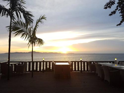
อ่างเก็บน้ำแม่ปืม เป็นอ่างเก็บน้ำที่มีทิวทัศน์สวยงามตั้งอยู่ระหว่างอำเภอเมืองและอำเภอแม่ใจ จังหวัดพะเยา มีเนื้อที่ประมาณ 5,000 ไร่ ห่างจากตัวจังหวัดพะเยามาทางจังหวัดเชียงรายประมาณ 22 กิโลเมตร บริเวณโดยรอบอ่างเป็นป่าเต็งรังซึ่งมีสภาพที่สมบูรณ์ และมีเส้นทางเดินชมป่าเต็งรังที่มีต้นพลวงเป็นไม้เด่น
![]()
![]()
ดอยงาม หรือเรียกอีกชื่อหนึ่งว่า ดอยหัวง้ม มีลักษณะเป็นภูเขายอดตัด มีที่ราบบนยอดดอยคล้ายภูกระดึง แต่มีความสูงน้อยกว่า ความสูงของพื้นที่เฉลี่ยประมาณ 800 เมตร มีที่ราบบนยอดดอยประมาณ 25 ตารางกิโลเมตร และเป็นภูเขาที่สูงที่สุดของอุทยานแห่งชาติแม่ปืม มีความสูงประมาณ 978 เมตรจากระดับน้ำทะเลปานกลาง เมื่อยืนอยู่ด้านบนสามารถชมดวงอาทิตย์ขึ้นและตก รวมทั้งทิวทัศน์ของภูเขาที่สลับซับซ้อน และบริเวณใกล้เคียงกับจุดชมดวงอาทิตย์นั้น มีดงกล้วยไม้ป่าซึ่งจะขึ้นตามต้นไม้และโขดหินเป็นจำนวนมาก ถัดจากดงกล้วยไม้มาทางด้านขวาจะมีลานหินแตกที่มีไลเคน มอส เกาะอยู่เป็นบริเวณกว้าง และบริเวณนี้เองที่มีสนสองใบขึ้นอยู่อย่างหนาแน่น นับว่าจุดชมทิวทัศน์ดอยงามแห่งนี้มีระบบนิเวศที่สมบูรณ์แห่งหนึ่ง ซึ่งเหมาะแก่การศึกษาค้นคว้าวิจัย และการกางเต็นท์พักแรม
![]()
![]()
จุดชมทิวทัศน์ดอยงามอยู่บริเวณหน่วยพิทักษ์อุทยานแห่งชาติ (ป่าแดงงาม) จากอำเภอพาน ไปตามทางหลวงจังหวัดหมายเลข 1126 สายอำเภอพาน-ป่าแดด ถึงหลักกิโลเมตรที่ 15 เลี้ยวขวาเข้าสู่หน่วยพิทักษ์อุทยานแห่งชาติ จากนั้นเดินขึ้นเขาไปประมาณ 3 กิโลเมตร ใช้เวลาเดินทางประมาณ 2 ชั่วโมง จะถึงจุดชมทิวทัศน์ดอยงาม
![]()
![]()
ดอยปุย เป็นจุดชมป่าเปลี่ยนสีที่งดงามมาก สามารถมองเห็นทิวทัศน์ไกลไปถึงตัวเมืองเชียงราย ไปตามทางหลวงจังหวัดหมายเลข 1020 สายเชียงราย-เทิง ประมาณ 9 กิโลเมตร จะพบทางแยกขึ้นสู่ดอยปุย
![]()
![]()
เขาสอง บนสันเขาสองมีลักษณะเป็นที่ราบซึ่งมีลานหินสลับทุ่งหญ้าและป่าสนเขา ในช่วงปลายฝนต้นหนาวจะมีดอกไม้บานเต็มทุ่งและลานหิน ผู้สนใจติดต่อเจ้าหน้าที่นำทางได้ที่ที่ทำการอุทยานแห่งชาติ เส้นทางขึ้นเขาอยู่บริเวณหน่วยพิทักษ์อุทยานแห่งชาติที่ (ป่าแดงงาม)
![]()
![]()
พระบาทตากผ้า พระบาทตากผ้า อยู่ใกล้เคียงกับหน่วยพิทักษ์อุทยานแห่งชาติที่ (ป่าแดงงาม) มีลักษณะเด่นคือ จะมีก้อนหินขนาดใหญ่ 2 ก้อน ก้อนหนึ่งจะมีรอยเท้าขนาดใหญ่ซึ่งเชื่อว่าเป็นรอยพระบาทของพระพุทธเจ้า และอีกก้อนหนึ่งจะมีรอยสี่เหลี่ยมผืนผ้าคล้ายรอยตากผ้า
![]()
![]()
สถานที่ติดต่ออุทยานแห่งชาติแม่ปืม หมู่ที่ 8 บ้านป่าตึง ต.แม่ใจ อ. แม่ใจ จ. พะเยา 56130
![]()
![]()
การเดินทาง รถยนต์ ที่ทำการอุทยานแห่งชาติแม่ปืมตั้งอยู่บริเวณอ่างเก็บน้ำแม่ปืมจากตัวเมืองพะเยาไปตามทางหลวงแผ่นดินหมายเลข 1 สายพะเยา-เชียงราย ถึงหลักกิโลเมตรที่ 754 จะมีทางแยกขวาเข้าสู่ที่ทำการอุทยานแห่งชาติ รวมระยะทางประมาณ 22 กิโลเมตร
![]()
![]()
สถานที่กางเต็นท์/เต็นท์ อุทยานแห่งชาติ ยังไม่ที่พัก-บริการไว้บริการนักท่องเที่ยว มีแต่สถานที่กางเต็นท์ให้บริการนักท่องเที่ยว เนื่องจากเป็นอุทยานแห่งชาติจัดตั้งใหม่ หากสนใจที่จะเดินทางไปท่องเที่ยวที่อุทยานแห่งชาติ นักท่องเที่ยวต้องจัดเตรียมเต็นท์และอาหารไปเอง
![]()
![]()
General Information Mae-puem National Park is situated in the areas of Chiang Rai Province and Phayao Province, covering an approximately area of 356 square kilometers or 222,500 rai. The National Park can be divided into 2 sections, including: Section 1 of the National Park is situated in the area of Doi-pui National Conserved Forest, Muang District, Chiang Rai Province, within the area of 67,500 rai; Section 2 of the National Park is situated in the areas of Mae-puem National Conserved Forest and Mae-pung Forest, covering Parn District and Pa-daeng District of Chiang Rai Province; and Mae-jai District and Muang District of Phayao Province; Mae-puem National Conserved Forest and Dong Pra-doo Forest in Mae-jai District and Muang District of Phayao Province; and Mae-Ing National Conserved Forest in Phu Kamyao Sub-district of Phayao Province, within an area of 248 square kilometers or 155,000 rai. Approximately 220 square kilometers or 137,431 rai of the areas of the National Park are situated in Chiang Rai Province; and approximately 136 square kilometers or 85,069 rai of the areas of the National Park are situated in Phayao Province. At present, Mae-puem National Park is being established as a national park.
![]()
![]()
Topography Section 1 The geographical features of the National Park consist of high mountains and few areas on the top of mountains, which are the sources of Mae-kaew River consisting of beautiful reefs and the flowing water throughout the year. The National Park slopes towards the east and the west of the area. And the highest mountaintop is situated in the north of the National Park. Section 2 The geographical features of the National Park consist of high mountains, extending southwards. The National Park slopes towards the east and the west of the area, and having flatlands on the mountain ridges. The area of Section 2 is approximately 4 kilometers wide and being the source of Mae-puem Gully with the flowing water throughout the year. And the highest mountaintop is situated in the north of the National Park.
![]()
![]()
Climate Since the area of the National Park is affected by the southwestern monsoon in the rainy season and affected by the northeastern monsoon in winter, the weather at the National Park is considerably cool, with the average temperature of 25ฐC, and the lowest temperature of 9-12C in December. Normally, there are heavy rains during May-October. And the average rainfall within the area of the National Park is approximately 1,550 mm/year.
![]()
![]()
Flora and Fauna There are 4 different kinds of forests within the areas of the National Park, including arid, evergreen forests, mixed forests, timber forests, and pinery. Major plants include teak, Xylia Xylocarpa (redwood plants), Leguminosae (Pradoo), Afzelia Xylocarpa Roxb., Dalbergia Oliveri Gamble (Ching Chan), timbers, Shorea Siamensis (Rang), Dipterocarpus Intricatus (Hiang), Pinus Merkusii Jungh (two-leaf pines), Lithocarpus Cantleyanus (Kor), etc. Due to the varieties of plants, there are more than 40 kinds of birds and other wild animals such as Muntiacus Muntjak, wild boars, tigers,
![]()
![]()
Mae-puem Reservoir Mae-puem is situated in an approximately area of 5,000 rai between Muang District and Mae-jai District of Phayao Province (approximately 22 km away from the city of Phayao to Chiang Rai Province). Interesting activities for tourists include recreations, sightseeing, natural studying, swimming, and canoeing.
![]()
![]()
Doi Ngam Doi Ngam or Doi Hua-ngom is a mesa with flatlands on the mountaintop (similar to Phu Kra-dueng). When standing on the mountaintop, you can watch a beautiful sunrise and sunset, as well as the scenery of mountains. In a nearby area, you can see a lot of wild orchids growing on trees and reefs. And next to the area of wild orchids, you can see the ground of cracked stones covered with mosses in a wide area, where two-leaf pines have thickly grown. The Sightseeing Spot has its perfect ecological system and being suitable for natural studying and camping.
![]()
![]()
Contact Address Mae Puem National Park Mu 8, Ban Pa Tueng, Mae Jai Sub-district, Amphur Mae Chai Phayao Thailand 56130
![]()
![]()
How to go? By Car From the city of Phayao, you may take Highway No.1 (Phayao-Chiang Rai) until reaching km. 754, then, make a right hand turn to the National Park’s office, situated in the area of Mae-puem Reservoir. The total distance is approximately 22 kilometers.
![]()
![]()
Latitude : 19.353677127031432, Longitude : 99.86726227889275
View Larger Map

View On Google Map
Edit Data
Images
-
อุทยานแห่งชาติแม่ปืม Mae Puem National Park
-

อุทยานแห่งชาติแม่ปืม Mae Puem National Park
-

อุทยานแห่งชาติแม่ปืม Mae Puem National Park
-

อุทยานแห่งชาติแม่ปืม Mae Puem National Park
-

อุทยานแห่งชาติแม่ปืม Mae Puem National Park
-
อุทยานแห่งชาติแม่ปืม Mae Puem National Park