Attraction อุทยานแห่งชาติดอยจง Doi Chong National Park : ลำปาง
ข้อมูลทั่วไป หากผ่านไปตามทางหลวงแผ่นดินหมายเลข 106 ช่วงรอยต่อระหว่างอำเภอเถิน จังหวัดลำปาง กับอำเภอลี้ จังหวัดลำพูน นักเดินทางจะมีโอกาสชื่นชมกับป่าเต็งรังและป่าเบญจพรรณที่ปกคลุมหนาแน่นสองฟากถนนยิ่งช่วงปลายฤดูหนาว ป่าผืนนี้จะยิ่งงดงามด้วยต้นไม้ที่พากันเปลี่ยนสีก่อนทิ้งใบร่วงในหน้าแล้ง ป่าผืนนี้เป็นป่าผลัดใบที่ยังคงความสมบูรณ์มากที่สุดอีกแห่งหนึ่ง และอยู่ภายในพื้นที่อนุรักษ์ของอุทยานแห่งชาติดอยจง มีพื้นที่ประมาณ 350,000 ไร่ หรือ 560 ตารางกิโลเมตร อยู่ในท้องที่อำเภอสบปราบ อำเภอเถิน อำเภอแม่พริก จังหวัดลำปาง และอำเภอลี้ จังหวัดลำพูน
อุทยานแห่งชาติดอยจง Doi Chong National Park
![]()
ลักษณะภูมิประเทศ มีลักษณะเป็นภูเขาทอดยาวตามแนวทิศเหนือไปทางทิศตะวันตกเฉียงใต้ มีเทือกเขาขนาดใหญ่เล็ก หลายลูกสลับซับซ้อน เทือกเขาเหล่านี้เป็นต้นกำเนิด ลำห้วยหลายสายไหลลงสู่แม่น้ำวัง ซึ่งเป็นแม่น้ำที่สำคัญของจังหวัดลำปางและยังเป็นแหล่งต้นน้ำสำหรับอ่างเก็บน้ำหลายแห่ง เช่น อ่างเก็บน้ำแม่ปราบ อ่างเก็บน้ำห้วยแม่ปู อ่างเก็บน้ำแม่ยอง สภาพโดยทั่วไปของพื้นที่เป็นภูเขาหิน มีแร่รัตนชาติ สังกะสี หินแกรนิต หินอ่อนอยู่โดยทั่วไป
![]()
ลักษณะภูมิอากาศ ในพื้นที่ระดับต่ำตามเชิงเขามีสภาพอากาศใกล้เคียงกับบริเวณอื่น ๆ ของภาคเหนือมีอุณหภูมิต่ำสุด 10 ํC อุณหภูมิสูงสุด 43 ํC ส่วนสภาพอากาศยอดเขาอุณหภูมิต่ำแตกต่างจากอากาศในพื้นที่ราบ มีอุณหภูมิต่ำสุดวัดได้ 4ํ ํC ปริมาณน้ำฝนเฉลี่ยวัดได้ 894 มิลลิเมตรต่อปี
![]()
พืชพรรณและสัตว์ป่า สภาพป่า ประกอบด้วยป่าประเภทต่าง ๆ ได้แก่ ป่าเต็งรัง ป่าเบญจพรรณ ป่าดิบแล้ง และป่าสนเขา มีสัตว์ป่าที่พบหลายชนิด เช่น หมีควาย เก้ง ลิงชนิดต่าง ๆ หมูป่า กระแต กระรอก พังพอน อีเห็น นกชนิดต่าง ๆ งูชนิดต่าง ๆ เป็นต้น
![]()
ดอยจง เป็นที่ราบกว้างซึ่งมีป่าสนเขาขึ้นกระจายเป็นกลุ่ม ๆ และมีหน้าผาเป็นจุดชมทิวทัศน์อยู่หลายแห่งสามารถชมทิวทัศน์ได้ทั้งยามดวงอาทิตย์ขึ้นจากขอบฟ้าในยามเช้าและลับขอบฟ้าในยามเย็น นอกจากนี้บนดอยจงยังพบกล้วยไม้จำนวนมาก โดยเฉพาะฟ้ามุ่ยซึ่งมีสีงดงามแปลกกว่าฟ้ามุ่ยในพื้นที่อื่น โดยจะออกดอกในช่วงเดือนตุลาคม-มกราคม จากที่ทำการอุทยานแห่งชาติมีเส้นทางเดินขึ้นสู่ยอดดอยจงระยะทางประมาณ 7 กิโลเมตร สภาพทางค่อนข้างชัน ใช้เวลาเดินขึ้นราวครึ่งวัน ผู้สนใจต้องติดต่อเจ้าหน้าที่ช่วยนำทาง
![]()
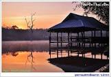
อ่างเก็บน้ำต่าง ๆ เป็นอ่างเก็บน้ำขนาดเล็กถึงขนาดกลาง ตั้งอยู่โดยรอบเขตอุทยานแห่งชาติ มีทัศนียภาพสวยงามเป็นอ่างเก็บน้ำแม่ทาย อ่างเก็บน้ำแม่ยอง อ่างเก็บน้ำแม่อาบ
![]()
นอกจากนี้อุทยานแห่งชาติดอยจงยังมีแหล่งท่องเที่ยวที่น่าสนใจอื่นอีก เช่น ถ้ำผาชัน น้ำตกตาดปู่หล้า น้ำตกธารมะไฟ และน้ำตกแม่แฮด
![]()
สถานที่ติดต่อ อุทยานแห่งชาติดอยจง หมู่ 6 ต.นายาง อ. สบปราบ จ. ลำปาง 52170
![]()
การเดินทาง รถยนต์ ที่ทำการอุทยานแห่งชาติดอยจง ตั้งอยู่ในพื้นที่อำเภอสบปราบ จังหวัดลำปาง การเดินทางเริ่มจากอำเภอเมือง จังหวัดลำปาง ไปตามทางหลวงแผ่นดินหมายเลข 1 (ถนนพหลโยธิน) ลงไปทางใต้ประมาณ 54 กิโลเมตร ถึงที่ว่าการอำเภอสบปราบ ให้เลี้ยวขวาไปตามถนนกรมโยธาธิการสายบ้านหล่าย – บ้านแก่น เมื่อถึงบ้านนาไม้แดง จากถนนพหลโยธิน ประมาณ 8 กิโลเมตร ให้เลี้ยวซ้ายไปอีกประมาณ 7 กิโลเมตร จะถึงที่ทำการอุทยานแห่งชาติดอยจง รวมระยะทางจากอำเภอเมือง จังหวัดลำปาง ถึงที่ทำการอุทยานแห่งชาติดอยจงประมาณ 68 กิโลเมตร
![]()
สถานที่กางเต็นท์/เต็นท์ อุทยานแห่งชาติ ยังไม่ที่พัก-บริการไว้บริการนักท่องเที่ยว มีแต่สถานที่กางเต็นท์ให้บริการนักท่องเที่ยว หากสนใจที่จะเดินทางไปท่องเที่ยวที่อุทยานแห่งชาติ ท่านสามารถนำเต็นท์และอาหารไปเอง หรือติดต่อขอใช้บริการเต็นท์ของอุทยานแห่งชาติ รายละเอียดเกี่ยวกับสถานที่กางเต็นท์/เต็นท์ ขอให้ติดต่อสอบถามกับอุทยานแห่งชาติโดยตรง
![]()
![]()
General Information Doi Chong National Park is situated in the areas of Sop Prap District, Thoen District, and Mae Phrik District of Lampang Province, and Li District of Lamphun Province. The geographical features of the National Park consist of high mountains. Doi Chong is the highest mountaintop of the National Park (1,339 meters above the sea level) with beautiful scenery and various kinds of forests including mixed forests, arid evergreen forests, and pinery, and being the source of streams and rivers.
![]()
![]()
Topography The topography of the National Park consist of small sized and large sized mountains, extending from the north to the southwest of the area. These mountains are the sources of many gullies flowing into Wang River (Wang River is the main river of Lampang Province and also being the water source for many reservoirs such as Maeprap Reservoir, Huai Maepu Reservoir, Mae-yong Reservoir, etc. In general, the topography of the area consist of stony mountains with decorative minerals, zinc, granite, and marble.
![]()
![]()
Climate The climate in lower areas at foothills of the National Park is similar to other areas in the Northern Region of which the highest temperature is 43 ํC and the lowest temperature is 10 ํC Meanwhile, temperatures on the mountaintops are lower than temperatures on flatlands of the National Park. The lowest temperature is 4 ํC and the average rainfall is 894 mm/year.
![]()
![]()
Flora and Fauna There are various kinds of forests within the areas of the National Park, including timber forests, mixed deciduous forests, arid evergreen forests, and pinery. Wild animals found in the National Park include Asiatic black bears, Muntiacus Muntjak, monkeys, wild boars, tree shrews, squirrels, mongooses, masked palm civets, birds, snakes, etc.
![]()
![]()
Doi Chong From the National Park’s office, you must take the jungle route for approximately 7 kilometers to the mountaintop, where you will be impressed with sightseeing spots for watching beautiful sunrise and sunset, as well as the surrounding scenery. From the sightseeing spots, you can view forests and high mountains of the National Park. The highest mountaintop of the National Park is situated at 1,339 meters above the sea level, with cool and breezy weather throughout the year. On the mountaintop of the National Park, there are different kinds of orchids, particularly a uniquely colourful Vanda Coerulea (Fah-mui), which blooms during October-January of every year. Activities : View Nature trail study Reservoirs There are small/medium-sized reservoirs with beautiful scenery surrounding the areas of the National Park including Mae-thai Reservoir, Mae-yong Reservoir, and Mae-arb Reservoir.
![]()
![]()
Contact Address Doi Chong National Park Mu 6, Na Yang Sub-district, Amphur Sop Prap Lampang Thailand 52170
![]()
![]()
How to go? By Car The National Park’s office is situated in Sop Prap District, Lampang District. From Mueang District of Lampang Province, you may take Highway No.1 (Phahonyothin Road) and go southwards for approximately 54 kilometers. When reaching Sop Prap District Office, make a right hand turn to Ban Lai–Ban Kaen Road. When reaching Ban Na Mai Daeng (approximately 8 km away from Phahonyothin Road ), make a left hand turn and go straight on for approximately 7 kilometers and you will reach the office of the National Park. The total distance from Mueang District of Lampang Province to the National Park’s office is approximately 68 kilometers.
![]()
![]()
![]()
![]()
Latitude : 17.91855063861193, Longitude : 99.24964452908496
View Larger Map

View On Google Map
Edit Data
Images
-
อุทยานแห่งชาติดอยจง Doi Chong National Park
-

อุทยานแห่งชาติดอยจง Doi Chong National Park
-

อุทยานแห่งชาติดอยจง Doi Chong National Park
-

อุทยานแห่งชาติดอยจง Doi Chong National Park
-
อุทยานแห่งชาติดอยจง Doi Chong National Park
-
อุทยานแห่งชาติดอยจง Doi Chong National Park