Attraction วนอุทยานน้ำตกตาดควัน Namtok Tat Khwan Forest Park : เชียงราย
วนอุทยานน้ำตกตาดควัน อยู่ในท้องที่หมู่ที่ 6 ตำบลตาดควัน อำเภอพญาเม็งราย จังหวัดเชียงราย อยู่ในเขตป่าสงวนแห่งชาติป่าดอยหลวง ป่าน้ำยาวและป่าน้ำซ้อ มีเนื้อที่ประมาณ 2,100 ไร่ กรมป่าไม้ได้ประกาศจัดตั้งเมื่อวันที่ 8 พฤษภาคม 2545

วนอุทยานน้ำตกตาดควัน Namtok Tat Khwan Forest Park
![]()
ลักษณะภูมิประเทศ เป็นภูเขาวางตัวในแนวทิศเหนือ-ใต้ สูงจากระดับน้ำทะเลปานกลางประมาณ 440-674 เมตร มีความลาดชันเฉลี่ยทั่วพื้นที่ 30 % มีลำห้วยตาดควันไหลผ่านตอนกลางของพื้นที่ ลำห้วยแม่ต๋ำไหลผ่านด้านทิศใต้ โดยลำห้วยตาดควันและลำห้วยแม่ต๋ำจะไหลมารวมกันเป็นลำน้ำแม่ต๋ำทางด้านทิศตะวันออกเฉียงใต้ ลำห้วยตาดควันและลำห้วยแม่ต๋ำเป็นห้วยขนาดใหญ่และมีน้ำไหลตลอดปี
![]()
พืชพรรณและสัตว์ป่า เป็นป่าดิบแล้ง สภาพป่ายังอุดมสมบูรณ์ มีพันธุ์ไม้เด่นที่พบได้แก่ ยางแดง ตะแบกแดง มะค่าโมง ประดู่ เติม ยมหิน แดงน้ำ ลำพูป่า เป็นต้น ไม้พื้นล่างเป็นพวกไผ่ซาง ไผ่ไร่ ไผ่หก กล้วยป่า หญ้าคา สาบเสือ เอื้องหมายนา เฟิร์น บอน
![]()
สัตว์ป่าที่พบมีจำนวนน้อยและเป็นสัตว์ขนาดเล็กจำพวกนก สัตว์เลื้อยคลาน สัตว์ฟันแทะ งูและปลาชนิดต่าง ๆ
![]()
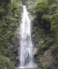
น้ำตกตาดควัน น้ำตกตาดควัน ซึ่งมีความสูงจากระดับน้ำทะเลปานกลางประมาณ 400 เมตร เป็นน้ำตกชั้นเดียวขนาดเล็กสูงประมาณ 15 เมตร มีน้ำไหลตลอดปี ด้นล่างน้ำตกมีสระน้ำ รอบๆน้ำตกเป็นป่าที่อุดมสมบูรณ์ ร่มรื่นและมีทิวทัศน์ที่สวยงาม
![]()
สถานที่ติดต่อ วนอุทยานน้ำตกตาดควัน ต.ตาดควัน อ. พญาเม็งราย จ. เชียงราย 57290 โทรศัพท์ 0 5371 4914 โทรสาร 0 5374 4961
![]()
การเดินทาง
![]()
รถยนต์ เดินทางจากอำเภอเมืองเชียงราย ถึงบ้านหัวดอย ระยะทาง กิโลเมตร ไปอำเภอพญาเม็งรายตามทางหลวงแผ่นดินหมายเลข 1152 ระยะทาง 40 กิโลเมตร เดินทางไปทางทิศใต้ตามทางหลวงแผ่นดินหมายเลข 1174 ถึงบ้านป่าม่วง ระยะทาง 14 กิโลเมตร ไปบ้านหมื่น 2.5 กิโลเมตร เป็นถนนกรมโยธาธิการ สายบ้านป่าม่วง-บ้านสันเวียง เลี้ยวขวาไปบ้านแม่ต๋ำน้ำตกตามถนนกรมโยธาธิการ สายบ้านป่าหมื่น-บ้านสันเวียง ระยะทาง 4 กิโลเมตร แล้วเดินทางต่อถึงวนฯอีก 8 กิโลเมตร ถนนเป็นดินลูกรัง รวมระยะทางทั้งหมด 74.5 กิโลเมตร
![]()
![]()
General Information Nam Tok Tad Khwan Forest Park located in Moo 6, Tad Khwan Sub-district, Paya Mengrai District, Chiang Rai Province, situated in Pah Doi Luang National Reserved Forest, Nam Yao Forest and Nam Sor Forest, covered the area of 2,100 rais. The Royal Forest Department declared this forest park on May 8, 2002.
![]()
Topography It is north-south laid mountain where is 440-674 metres above the average sea level. The approximately slope is 30% in general. There are Tad Khwan Stream flows through the middle of the area and Mae Ta Lai Stream flows through the south. Both streams will be gathered to be Mae Tam River at the southeast. These streams are big. The water flows throughout the year.
![]()
Flora and Fauna It is abundant Dry Deciduous Forest. Dominant flora species found consist of Dipterocarpus turbinatus, Lagerstroemia calyculata, Afzelia xylocarpa, Pterocarpus macrocarpus, Chukrasia venlutina, Amoora cucullata, Duabanga grandiflora, and so on. Ground plant species are Dendrocalamus strictus, Giantochloa albocilia, Dendrocalamus hamiltonii, Musa acuminata, Imperata cylindrical, Eupathorium odoratum, Costus speciosus, fern, elephant’s ear, etc.
![]()
A number of fauna species found is small and most of fauna species found are small animals such as birds, reptiles, rodents, snakes and various fishes.
![]()
Tad Khwan Waterfall Tad Khwan Waterfall is 400 metres above the average sea level. It is small one floor waterfall where is approximately 15 metres high. The water is flowing throughout the year. There is a pond down the waterfall. Tad Khwan Waterfall is covered with abundant and shady trees. Its scenery is fantastic.
![]()
Contact Address Namtok Tat Khwan Forest Park Tad Khwan Sub-district, Amphur Phaya Mengrai Chiang Rai Thailand 57290Tel. 0 5371 4914 Fax 0 5374 4961
![]()
How to go?
![]()
By Car You can from Chiang Rai town to Ban Hua Doi and further to Phaya Mengrai on the Highway no. 1152 which will take 40 kms. After that drive down south on the Highway no. 1174 to Ban Pah Muang which is 14 kms long, and then to Ban Muen for 2.5 kms on thr Ban Pah Muang-Ban Sun Vieng route. Turn right to Ban Mae Tam Nam Tok on the Ban Pah Meun-Ban Sun Vieng which is 4 kms. After that drive forward on the dirt road to the forest park which will take 8 kms. Hence the total distance to reach the forest park is 74.5 kms.
![]()
![]()
![]()
![]()
Latitude : 20.01267623329773, Longitude : 100.19389039743994
View Larger Map

View On Google Map
Edit Data
Images
-
วนอุทยานน้ำตกตาดควัน Namtok Tat Khwan Forest Park
-
วนอุทยานน้ำตกตาดควัน Namtok Tat Khwan Forest Park
-

วนอุทยานน้ำตกตาดควัน Namtok Tat Khwan Forest Park
-

วนอุทยานน้ำตกตาดควัน Namtok Tat Khwan Forest Park
-

วนอุทยานน้ำตกตาดควัน Namtok Tat Khwan Forest Park