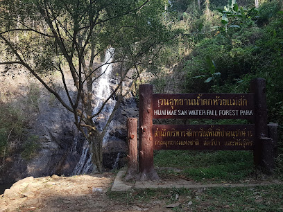
Attraction วนอุทยานน้ำตกห้วยแม่สัก Huai Mae Sak Waterfall : เชียงราย
ข้อมูลทั่วไป วนอุทยานน้ำตกห้วยแม่สัก อยู่ในท้องที่บ้านน้ำตกพัฒนา หมู่ที่ 7 ตำบลทุ่งก่อ กิ่งอำเภอเวียงเชียงรุ้ง จังหวัดเชียงราย อยู่ในเขตป่าสงวนแห่งชาติป่าห้วยสักและป่าแม่กกฝั่งขวา มีเนื้อที่ประมาณ 2,800 ไร่ กรมป่าไม้ได้ประกาศจัดตั้งเป็นวนอุทยานเมื่อวันที่ 8 พฤษภาคม 2545
วนอุทยานน้ำตกห้วยแม่สัก Huai Mae Sak Waterfall
![]()
ลักษณะภูมิประเทศ เป็นภูเขาวางตัวในแนวทิศตะวันตกเฉียงใต้-ตะวันออกเฉียงเหนือ สูงจากระดับน้ำทะเลปานกลางประมาณ 460-963 เมตร มีความลาดชันเฉลี่ยทั่วพื้นที่ประมาณ 30 % มีลำห้วยแม่สักเป็นห้วยขนาดใหญ่ มีน้ำไหลตลอดทั้งปี และเป็นแหล่งต้นน้ำของน้ำตกห้วยแม่สัก ซึ่งไหลผ่านกลางพื้นที่
![]()
พืชพรรณและสัตว์ป่า เป็นป่าเบญจพรรณที่มีไม้สักขึ้นอยู่ สภาพป่าบริเวณน้ำตกห้วยสักยังอุดมสมบูรณ์แต่ในบริเวณอื่นไม่ค่อยสมบูรณ์เนื่องจากในอดีตเคยถูกบุกรุก ปัจจุบันป่าเริ่มฟื้นตัว มีพันธุ์ไม้ที่พบได้แก่ ตะแบกเกรียบ สัก กระท่อมหมู เลี่ยน เติม ไม้พื้นล่างเป็นพวกไผ่ กล้วยป่า ผักคราด หญ้าคา สาบเสือ กลอย หญ้าคมบาง บอน และเฟิร์น
![]()
สัตว์ป่าที่พบได้แก่ กระต่ายป่า อ้นเล็ก กระจ้อน กระแต พังพอน ไก่ป่านกกระปูด นกเขาเปล้า นกกางเขนดง นกปรอดหัวโขน สัตว์ครึ่งบกครึ่งน้ำ สัตว์เลื้อยคลานและปลาชนิดต่างๆ
![]()
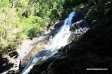
น้ำตกห้วยแม่สัก น้ำตกห้วยแม่สัก สูงจากระดับน้ำทะเลปานกลางประมาณ 480 เมตร เป็นน้ำตกชั้นเดียวขนาดเล็กสูงประมาณ 15 เมตร มีน้ำไหลตลอดปีรอบๆน้ำตกเป็นป่าที่สมบูรณ์ร่มรื่น และมีทิวทัศน์งดงาม
![]()
สถานที่ติดต่อ วนอุทยานน้ำตกห้วยแม่สัก ต.ทุ่งก่อ อ. กิ่งอำเภอเวียงเชียงรุ้ง จ. เชียงราย 57210 โทรศัพท์ 0 5371 4914 โทรสาร 0 5374 4961
![]()
การเดินทาง รถยนต์ เดินทางจากอำเภอเมืองเชียงรายผ่านอำเภอเวียงชัยถึงบ้านเหล่าเจริญราษฎร์ ตามทางหลวงแผ่นดินหมายเลข 1233 ระยะทาง 34 กิโลเมตร แล้วเดินไปทางทิศใต้ถึงบ้านน้ำตกพัฒนา ตามถนนกรมโยธาธิการสายบ้านเหล่าเจริญราษฎร์ ระยะทาง 6 กิโลเมตร แล้วเดินทางต่อไปอีก 2 กิโลเมตร ก็จะถึงวนฯ ถนนเป็นดินลูกรัง รวมระยะทางทั้งหมด 42 กิโลเมตร
![]()
![]()
General Information Huay Mae Sak Waterfall Forest Park located in Nam Tok Pattana Village, Moo 7; Tung Kor King Sub-district, Viang Chiang Rung District, Chiang Rai Province, situated in Pah Huay Sak National Reserved Forest and eastern Mae Kok Forest, covered the area of approximately 2,800 rais. The Royal Forest Department declared this forest park on May 8, 2002.
![]()
Topography The mountain laid from southwest towards northeast, approximately 460-963 metres above the average sea level and 30% average slope. Huay Mae Sak is a big stream in this area and the water flows throughout the year. It’s the watershed area of Huay Mae Sak Waterfall that is flowing through the area.
![]()
Flora and Fauna It’s Mixed Deciduous Forest where teak is available. Forest around the Huay Sak Waterfall is still abundant. However, it’s different in other area because the encroachment in the past. Presently the forest has been recovered. Flora species found consist of Lagerstroemia balansae, teak, Mitragyna brunonis, Melia azedarach, Bischofia javanica, etc. Ground plants consist of bamboo species, wild banana, Spilanthes iabadicensis, Imperata cylindrica, Siam weed, wild jam, Cyperaceae genus, Araceae genus and fern.
![]()
Fauna found consists of wild rabbit, bay bamboo rat, Indochinese ground squirrel, mongoose, jungle fowl, coucal, thick-billed pigeon, white-rumped shama, red-whiskered bulbul, amphibian, reptile, and various fishes.
![]()
Huay Mae Sak Waterfall Huay Mae Sak Waterfall is approximately 480 metres above the average sea level. It’s one floor waterfall which is about 15 metres height. Water flows throughout the year. It’s surrounded with shading trees and beautiful scenery.
![]()
Contact Address Namtok Huai Mae Sak Forest Park Thung Kor Sub-district, Amphur King Amphoe Wiang Chiang Rung Chiang Rai Thailand 57210Tel. 0 5371 4914 Fax 0 5374 4961
![]()
How to go? By Car From Chiang Rai town, you can take the Highway no. 1233 pass Vieng Chai District to Lao Charoen Village. It takes 34 kms long. After that take the Krom Yothathikarn Road southwards to Lao Charoen Village and then to Nam Tok Pattana Village. This will take about 6 kms. Later, drive further on the dirt road for 2 kms long, to reach the forest park. The distance from Muang District of Chiang Rai to Nam Tok Huay Mae Sak Forest Park is totally 42 kms.
![]()
![]()
![]()
![]()
Latitude : 19.957201993085828, Longitude : 100.07938706860303
View Larger Map

View On Google Map
Edit Data
Images
-
วนอุทยานน้ำตกห้วยแม่สัก Huai Mae Sak Waterfall
-

วนอุทยานน้ำตกห้วยแม่สัก Huai Mae Sak Waterfall
-

วนอุทยานน้ำตกห้วยแม่สัก Huai Mae Sak Waterfall
-
วนอุทยานน้ำตกห้วยแม่สัก Huai Mae Sak Waterfall
-

วนอุทยานน้ำตกห้วยแม่สัก Huai Mae Sak Waterfall
-

วนอุทยานน้ำตกห้วยแม่สัก Huai Mae Sak Waterfall