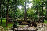
Attraction วนอุทยานผาหินตั้ง Pha Hin Tang Forest Park : แม่ฮ่องสอน
ข้อมูลทั่วไป วนอุทยานผาหินตั้ง ตั้งอยู่ในท้องที่บ้านห้วยเดื่อ หมู่ 3 ตำบลผาบ่อง อำเภอเมือง จังหวัดม่ฮ่องสอน และอยู่ในเขตป่าสงวนแห่งชาติ ป่าแม่ปายฝั่งขวา ตามกฎกระทรวงฉบับที่ 1,233 (พ.ศ. 2534) มีเนื้อที่ประมาณ 3500 ไร่ กรมป่าไม้ได้ดำเนินการจัดตั้งเมื่อวันที่ 13 มกราคม 2540
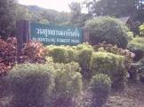
วนอุทยานผาหินตั้ง Pha Hin Tang Forest Park
![]()
![]()
ลักษณะภูมิประเทศ สภาพพื้นที่โดยทั่วไปเป็นภูเขาและมีที่ราบเนินเขาริมน้ำปาย มียอดเขาสูงสุดจากระดับน้ำทะเลปานกลางประมาณ 630 เมตร หินเป็นหินปูน ดินตามภูเขาและที่ราบเป็นดินร่วนปนทรายและดินลูกรัง อยู่ในเขตกำหนดชั้นคุณภาพลุ่มน้ำชายแดนตามมติ ค.ร.ม. เมื่อวันที่ 21 กุมภาพันธ์ 2538 ชั้น 1A และชั้น 3 และอยู่ในเขตจำแนกการใช้ประโยชน์ทรัพยากรและที่ดินป่าไม้ในเขตป่าสงวนแห่งชาติตามมติ ค.ร.ม. เมื่อวันที่ 17 มีนาคม 2535 ประเภทป่าเพื่อการอนุรักษ์
![]()
![]()
ถ้ำน้ำเพียงดิน ถ้ำน้ำเพียงดิน เป็นถ้ำหินปูนภายในมีความกว้างพอสมควร ลึกประมาณ 50 เมตร มีหินย้อยสวยงามอยู่ทั่วไป บริเวณปากถ้ำเป็นที่ตั้งของวัดถ้ำน้ำเพียงดิน ทางวัดมีการเข้าไปปรับปรุงตกแต่งในถ้ำบ้าง เช่น นำพระพุทธรูปไปไว้ในถ้ำและปากถ้ำ และสิ่งแปลกคือมีน้ำไหลออกจากตัวถ้ำตลอดเวลา
![]()
![]()
หมู่บ้านกระเหรี่ยงคอยาว หมู่บ้านกระเหรี่ยงคอยาว บ้านปูแกง เป็นหมู่บ้านที่มีกระเหรี่ยงคอยาวมาอาศัยอยู่ มีการแต่งตัวและขายของที่ระลึกแก่นักท่องเที่ยวมาเที่ยวชมทุกวัน
![]()
![]()
บ้านน้ำเพียงดิน บ้านน้ำเพียงดิน เป็นหมู่บ้านที่ติดกับแนวเขตชายแดนประเทศสหภาพพม่า นักท่องเที่ยวนิยมไปเที่ยวหมู่บ้านนี้
![]()
![]()
สถานที่ติดต่อ วนอุทยานผาหินตั้ง ต.ผ่าบ่อง อ. เมืองแม่ฮ่องสอน จ. แม่ฮ่องสอน 58000 โทรศัพท์ 0 5361 2078 โทรสาร 0 5361 2078
![]()
![]()
การเดินทาง รถยนต์ จากตัวจังหวัดแม่ฮ่องสอนไปตามเส้นทางหลวงหมายเลข 108 ไปทางอำเภอแม่สะเรียง ประมาณ 10 กิโลเมตร เลี้ยวขวาเข้าหมู่บ้านแม่สะกึด ผ่านบ้านแม่สะกึดพบทางแยกไปบ้านน้ำเพียงดินเลี้ยวซ้ายประมาณ 8 กิโลเมตร ถึงวนอุทยานที่จะจัดตั้งหรือเดินทางออกจากตัวจังหวัดแม่ฮ่องสอนเลี้ยวขวาผ่านบ้านท่าโป่งแดง เลี้ยวซ้ายไปบ้านห้วยเดื่อ ผ่านบ้านห้วยเดื่อไปทางบ้านแม่สะกึดเลี้ยวขวาไปบ้านน้ำเพียงดิน
![]()
![]()
เรือ ออกจากตัวจังหวัดแม่ฮ่องสอนโดยทางรถยนต์ เลี้ยวขวาผ่านบ้านท่าโป่งแดงเลี้ยวซ้ายไปบ้านห้วยเดื่อ ประมาณ 6 กิโลเมตร จะมีท่าเรือบ้านห้วยเดื่อ มีเรือรับจ้างเดินทางไปหมู่บ้านกะเหรี่ยงคอยาวและบ้านน้ำเพียงดิน ซึ่งผ่านบริเวณที่จะจัดตั้งวนอุทยาน ซึ่งนักท่องเที่ยวนิยมใช้เส้นทางนี้เนื่องจากสามารถชมทัศนียภาพธรรมชาติสวยงามสองฝากฝั่งลำน้ำปาย
![]()
![]()
![]()
General Information Pha Hin Tung Forest Park located in Moo 3, Huay Dua Village, Pha Bong Sub-district, Muang District, Mae Hong Sorn province, situated in eastern Pah Mae Pai National Reserved Forest. Referring to the ministerial regulation, issue 1,233 (1991), covered the area of 3,500 rais approximately. The Royal Forest Department declared this forest park on January 13, 1997
![]()
![]()
Topography Generally, it’s mountainous area with hilly plain by the Pai River bank. Its summit is about 630 metres above average sea level. Stone type is limestone, mountain soil, and friable soiled and rouge soiled plain. Based on the resolution from the cabinet meeting held on February 21, 1995, this area was stipulated to be the 1A and 3 of border river basin quality zone. In addition, the result of the cabinet meeting held on March 17, 1993 also classified this area as the conserving forest of the segregation zone of natural resources and forestry land in the national park
![]()
![]()
Flora and Fauna It is very abundant forest because it is situated on high and complex mountains where is saved from encroachments. Forest types found are as follows:
![]()
![]()
The Mixed Deciduous Forest has been mostly found here. It is a clear forest consists of various big and average trees. Somewhere consists of various bamboo species scattered grown. They have been found around foothill and mountain ridge. Tree species found are teak, Pterocarpus macrocarpus, SOMPONG, KWAO, Leguminosae Genus, Dalbergia dongniensis, and so on. Bamboo species found are Bambusa sp., and Dendrocalamus strictus.
![]()
![]()
It is the clear forest where is consisting of big, average and small trees mixed-grown. There are grasses grown on the ground. Soil type is sandy soil mixed with dirt soil. Flora found consists of Dipterocarpus turbinatus, Shorea siamensis, Dipterocarpus obtusifolius, Cratoxylum sp., and so on.
![]()
![]()
Hill Evergreen Forest: it’s found along the valleys and streams. It is crowded forest where is consisting of annual plants, vines, rattans, orchids, and various bamboo species as well as ferns trail around. Flora found such as Lithocarpus annamensis, black plum, Ficus sp., and queen’s flower.
![]()
![]()
Tourist Attractions Pha Hin Tang is like huge erected limestone situated on the Pai River bank. The area nearby is hilly plain. This erected stone is like the cliff and the water influence causes
![]()
![]()
Nam Pieng Din Cave Nam Pieng Din Cave is limestone cave. It’s quite big inside with 50 metres depth. Beautiful stalactites decorated around. At the entrance of the cave locates the Nam Pieng Din Temple. Monks and people in the temple have been doing some decoration inside the cave such as placing Buddha images at the entrance and inside the cave. One ordinary thing is there’s water flows out of the cave all the time.
![]()
![]()
Long Necked Karen Community Long Necked Karen Community is at Poo Kaeng Village. It’s where long necked Karen live. They dress in their traditional costumes and sell souvenirs to the tourist everyday.
![]()
![]()
Nam pieng Din Village Nam Pieng Din Village is located close to Thai-Burma border. It’s popular among the tourists.
![]()
![]()
Latitude : 19.27052010855141, Longitude : 97.90111749873186
View Larger Map

View On Google Map
Edit Data
Images
-
วนอุทยานผาหินตั้ง Pha Hin Tang Forest Park
-

วนอุทยานผาหินตั้ง Pha Hin Tang Forest Park
-
วนอุทยานผาหินตั้ง Pha Hin Tang Forest Park
-

วนอุทยานผาหินตั้ง Pha Hin Tang Forest Park
-

วนอุทยานผาหินตั้ง Pha Hin Tang Forest Park
-

วนอุทยานผาหินตั้ง Pha Hin Tang Forest Park