Attraction อุทยานแห่งชาติภูลังกา Phu Langka National Park : นครพนม
อุทยานแห่งชาติภูลังกา Phu Langka National Park
![]()
สภาพป่าโดยทั่วไปเป็นป่าดิบเขา ป่าดงดิบ ป่าเบญจพรรณ และป่าแดงที่สมบูรณ์ มีสัตว์ป่าชุกชุม เป็นต้นกำเนิดของลำห้วยหลากสาย และมีจุดเด่นทางธรรมชาติ เช่น หน้าผา ถ้ำ น้ำตก อยู่หลายแห่ง
![]()
ลักษณะภูมิอากาศ ในพื้นที่มีสภาพภูมิอากาศ โดยทั่ว ๆ ไปแล้วจะมีสภาพอากาศใกล้เคียงกับบริเวณอื่นๆของภาคตะวันออกเฉียงเหนือ ส่วนสภาพอากาศบนยอดเขาจะมีลักษณะเป็นหิน ฤดูหนาวจะมีอากาศหนาวจัด ประมาณ 0-5 องศาเซลเซียส โดยอุณหภูมิเฉลี่ยตลอดปีประมาณ 25-36 องศาเซลเซียส
![]()
พืชพรรณและสัตว์ป่า พื้นที่อุทยานแห่งชาติภูลังกาปกคลุมด้วยป่าดิบแล้ง ป่าเบญจพรรณ และป่าเต็งรัง ดอกไม้ป่าที่มีอยู่โดยทั่วไป โดยเฉพาะกล้วยไม้ป่า รองเท้าแตะนารี เท่าที่พบในปัจจุบันส่วนมากจะเป็นกล้วยไม้ตระกูลหวายและแดงอุบล นอกจากนั้นภูลังกายังเป็นแหล่งสมุนไพรต่าง ๆ และว่านนานาชนิด ภูลังกาในปัจจุบันเท่าที่พบและได้ข้อมูลจากชาวบ้าน ปรากฏว่ายังมีสัตว์ป่าประเภทสัตว์เลี้ยงลูกด้วยนม เช่น หมูป่า ลิง อีเห็น เก้ง อยู่เป็นจำนวนมาก พร้อมทั้ง กระรอก กระแต บ่าง และนอกจากนี้ยังมีสัตว์ปีกจำพวกนกต่าง ๆ หลายชนิด ที่เด่น ๆ อีกจำพวกหนึ่งคือ สัตว์เลื้อยคลาน ได้แก่ กระท่าง และงู อีกหลาย ๆ ชนิด
![]()
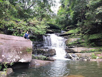
อุทยานแห่งชาติภูลังกา มีช่วงเวลาที่เหมาะสมในการท่องเที่ยวระหว่างเดือนมีนาคม-ตุลาคม และมีแหล่งท่องเที่ยวที่น่าสนใจดังนี้ น้ำตกตาดขาม เกิดจากลำธารหลายสายบนยอดเขาไหลมาบรรจบกันเป็นลำห้วยขาม เป็นน้ำตกที่ไม่สูงนัก และบริเวณใกล้ๆ มีลานหินเล็กๆ สำหรับพักผ่อน มีน้ำตกไหลเป็นชั้นๆ จำนวน 4 ชั้น เฉพาะชั้นสุดท้ายจะมีแอ่งน้ำขังตลอดปี น้ำตกตาดขาม เป็นที่รู้จักของประชาชนจังหวัดใกล้เคียง เช่น หนองคาย สกลนคร อุดรธานี ฯลฯ มีประชาชนเดินทางมาเที่ยวชมทุกๆ วัน วันละประมาณ 100 คน โดยเฉลี่ยและวันหยุดต่างๆ จะมีไม่น้อยกว่า 400-500 คน
![]()
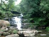
น้ำตกตาดโพธิ์ มีน้ำตกไหลเป็นชั้นๆ แต่ละชั้นสูงไม่น้อยกว่า 10 เมตร โดยเฉพาะชั้นที่ 2 มีความสูงถึง 30 เมตร ซึ่งในฤดูฝนสามารถมองเห็นได้จากถนนสายนครพนม-หนองคาย โดยเห็นได้ชัดเจนและมีความสวยงาม
![]()
ภูลังกาเป็นภูเขาที่อยู่โดดเดี่ยว มีหน้าผาที่สวยงามสองด้านคือ ด้านภูลังกาใต้และภูลังกาเหนือ ด้านบนภูลังกามีลานหินกว้างอยู่หลายแห่งที่สวยงามแปลกตา กิจกรรม -ชมทิวทัศน์ ปฎิมากรรมหินบนภูลังกา มีหินที่มีลักษณะน่าสนใจอยู่หลายแห่ง เช่น กองข้าวสีบุญเนาเป็นหินที่มีลักษณะคล้ายกองข้าว และมีร่องรอยดูคล้ายทางเกวียนอยู่ใกล้เคียงกัน อีกแห่งหนึ่ง คือ โคกตะละปัด ซึ่งมีลานหินกว้างๆ สวยงาม มีรูปรอยการแกะสลักหิน ก้อนหินที่ถูกแกะมีรูปร่างเหมือนตะละปัด
![]()
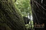
ถ้ำต่างๆ ถ้ำที่สวยงามใหญ่และน่าสนใจ ได้แก่ ถ้ำยา ถ้ำพ่อหง่า ถ้ำตาทัด ถ้ำเกีย และถ้ำอาจารย์วัง กิจกรรม -เที่ยวถ้ำ/ธรณีวิทยา สถานที่ติดต่อ อุทยานแห่งชาติภูลังกา ต. นางัว อ. บ้านแพง จ. นครพนม 48140 การเดินทาง รถยนต์ ภูลังกาตั้งขนานกับทางหลวงแผ่นดินหมายเลข 212 (นครพนม-บ้านแพง-หนองคาน) ประมาณ 105 กิโลเมตร ห่างจากก้าวจังหวัดหนองคาย 220 กิโลเมตร ห่างจากตัวอำเภอบ้านแพงประมาณ 6 กิโลเมตร
![]()
การเดินทางไปภูลังกาสะดวกสบายทุกฤดูกาล ถ้าตั้งต้นจากกรุงเทพฯ สามารถใช้เส้นทางได้หลายเส้นทาง คือ กรุงเทพ-อุดร-พังโคน-วานรนิวาส-เซกา-บ้านแพง หรือจะใช้เส้นทาง กรุงเทพ-สกลนคร-นครพนม-บ้านแพง
![]()
สถานที่กางเต็นท์/เต็นท์ อุทยานแห่งชาติ ยังไม่ที่พัก-บริการไว้บริการนักท่องเที่ยว มีแต่สถานที่กางเต็นท์ให้บริการนักท่องเที่ยว ทั้งนี้ เนื่องจากเป็นอุทยานแห่งชาติจัดตั้งใหม่ หากสนใจที่จะเดินทางไปท่องเที่ยวที่อุทยานแห่งชาติ นักท่องเที่ยวต้องจัดเตรียมเต็นท์และอาหารไปเอง
![]()
![]()
General Information Phu Lang ka National Park, about 31,250 Rais or 50 squares kilometers, covers the area in Baan Pang District, Nakhon Phanom Province, and Sega District, Nong Khai Province. There generally are productive forests such as montane forest, rain forest, mixed forest and deciduous forest. The area is the source of water, habitat of a number of animals, and has many wonderful places to visit such as cliffs, caves and waterfalls. Despite the beautiful scenery and productive forest, the area also has varieties of life and environment. The area has three mountains, overlapping each other and lying north and south, alternating with mountain ranges and small mountains along with Khong River. The highest peak is about 563 meters above sea level. This mountain Range is the source of many rivers which flow to Khong River in Baan Pair District and are valuable for agriculture of people around Phu Lang ka National Park
![]()
Climate The weather in this area is the same as other parts of Northeastern Thailand. At the top of the mountains is cold temperature about 0-5 degrees Celsius, approximately 25-36 degrees Celsius all the year round. The area has 1,860 mm. of rain per year.
![]()
Flora and Fauna Generally, plants found are wild flower especially Lady’s Slipper Orchid which used to be taken for export until it is almost extinct. So almost of flowers now are orchids in family of ARACEAE and ORCHIDACEAE, and many kinds of herb. Most of animals, often found and told by local people, are mammals such as wild boar, monkey, palm civet, barking deer, squirrel, flying squirrel, chipmunk, many kinds of bird, and reptiles such as salamander and snake.
![]()
Tard Kham Waterfall Tard Kham Waterfall is not very cascade cascading four levels. There is also a small rock-floor nearby for recreation. The lowest level is a pond which has water all the year round. It is well known by visitor from around the area such as Nong Khai Province, Sakhon Nakhon Province, Udon Thani Province etc. Everyday has about 100 visitors, and, especially, on weekend or holiday there is about 400-500 visitors.
![]()
Tard Phor Waterfall Tard Phor Waterfall is a very beautiful cascade each of which layers higher than 10 meters; especially at second layer is 30 meters high. There is clearly seen from the road Nakhon Phanom – Nong Khai in rainy season. Despite the waterfall, the area also consists of many wonderful places such as big and small caves, for examples, Ya Cave, Por Nga Cave, Tar Tad Cave, Gear Cave and Ajarn Wang Cave.
![]()
Cliffs Phu Lang ka is a stand alone mountain which has two beautiful cliffs in other side, these are, Phu Lang ka Tai and Phu Lang ka Nuar. And on the top of it lay beautiful plains of rock.
![]()
Phu Lang ka Rock There are many interesting rocks such as; Kong Khao Si Boon Nauo which is a group of rock look like a pile of rice-straw and has a look-like rut of cart nearby; and Koge Tala Pat which has large plain of rock consist of carved rock look like Tala Pat (a priest’s tool for sermoning) and carvings on rocks.
![]()
Contact Address Phu Langka National Park Na Ngua Sub-district, Amphur Ban Phaeng Nakhon Phanom Thailand 48140
![]()
How to go? By Car Phu Lang ka locates close to and parallel with national road number 212 (Nakhon Phanom – Baan Pang – Nong Khan) about 105 kilometers. And 220 kilometers far from Nong Khai Province, and 6 kilometers from Baan Pang District. How to get there is convenient in any seasons, and also has many ways such as Bangkok – Udon – Pang Kone – Wanorn Niwas – Sega – Baan Pang or Bangkok - Sakhon Nakhon – Nakhon Phanom – Baan Pang. Traveling season starts from March to October.
![]()
![]()
![]()
![]()
Latitude : 17.98473543196693, Longitude : 104.14019219704797
View Larger Map

View On Google Map
Edit Data
Images
-
อุทยานแห่งชาติภูลังกา Phu Langka National Park
-
อุทยานแห่งชาติภูลังกา Phu Langka National Park
-

อุทยานแห่งชาติภูลังกา Phu Langka National Park
-

อุทยานแห่งชาติภูลังกา Phu Langka National Park
-

อุทยานแห่งชาติภูลังกา Phu Langka National Park
-
อุทยานแห่งชาติภูลังกา Phu Langka National Park