Attraction น้ำตกสิรินธร Sirinthorn Waterfall : นราธิวาส
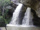
น้ำตกสิรินธร ลักษณะโดยทั่วไปไม่ใช่น้ำที่ตกมาจากผาสูง หากแต่เป็นลักษณะธารที่ค่อย ๆ ลาดไหลมาจากแนวป่าสูง มีแอ่งน้ำลานหิน นั่งพักผ่อนได้ ธารน้ำตกจะไหลไปรวมที่คลองอัยกาดิง มักจะมีคนท้องถิ่นเข้ามาเที่ยว สิ่งที่ควรชมนอกเหนือจากน้ำตก ก็คือ โครงการสำรวจและรวบรวมพันธุ์ไม้ดอก ไม้ประดับ ป่าภาคใต้ ในสมเด็จพระเทพรัตนราชสุดาฯ สยามบรมราชกุมารี มีการรวบรวมไว้กว่า 200 ชนิด โดยจัดปลูก พรรณไม้ต่าง ๆ ไว้เป็นหมวดหมู่ ตามสภาพธรรมชาติ และมีป้ายบอกชื่อ รวมทั้งประโยชน์ใช้สอยติดไว้ให้ศึกษา มีความน่าสนใจทั้งในแง่พฤกษศาสตร์พื้นบ้าน และการนำมาเพาะเลี้ยงขยายพันธุ์ เพื่อพัฒนาเป็นไม้ประดับ และพืชเศรษฐกิจ ผู้สนใจเข้าชมได้ระหว่างเวลา 8.30 - 16.00 น.

น้ำตกสิรินธร Sirinthorn Waterfall
![]()
การเดินทางสู่ น้ำตกสิรินธร อยู่ห่างจากอำเภอแว้งไปตามทางหลวงแผ่นดินหมายเลข 4057 ประมาณ 7 กิโลเมตร จากนั้นแยกเข้าไปตามถนนเพื่อความมั่นคงอีกประมาณ 8 กิโลเมตร จากปากทางเข้าไปอีกประมาณ 300 เมตร
![]()
![]()
The water of Sirindhorn waterfall does not fall from a high cliff. It, however, streams along the slope of a high hill and goes down to Aiyakading Canal. Near the waterfall, there are rock pools where you can sit and relax. This waterfall is frequently visited by Local people.
![]()
Namtok Sirindhorn is unlike a waterfall in general which flows from a high cliff. It features a stream flowing along a high line of forest. There is a pool and a stony ground for leisure. The stream flows into Khlong Aikading. Local people usually visit the waterfall. Apart from the waterfall, another interesting thing is the “Project to Survey and Collect Flowers and Ornamental Plants in the Southern Forest of HRH Princess Maha Chakri Sirindhorn.” More than 200 species of plants have been collected, grown, and categorized according to their natural conditions, with name tags and utility for study. The Project is an interest in terms of local botany and further breeding to be ornamental plants and cash crops. Interested people can visit the Project during 8.30 a.m.-4.00 p.m.
![]()
To get there : From Amphoe Waeng, take Highway 4057 for around 7 km. Then, take a turn to follow the Security Road for around 8 km, and go further for about 300 m from the entrance.
![]()
Latitude : 5.802433364271674, Longitude : 101.82650496849975
View Larger Map

View On Google Map
Edit Data
Images
-
น้ำตกสิรินธร Sirinthorn Waterfall
-

น้ำตกสิรินธร Sirinthorn Waterfall
-

น้ำตกสิรินธร Sirinthorn Waterfall
-
น้ำตกสิรินธร Sirinthorn Waterfall
-

น้ำตกสิรินธร Sirinthorn Waterfall
-

น้ำตกสิรินธร Sirinthorn Waterfall