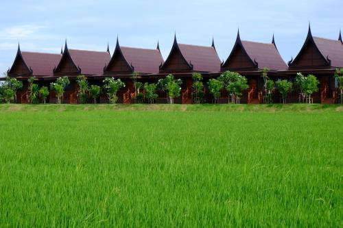
Attraction วนอุทยานพุม่วง Phu Muang Forest Park : สุพรรณบุรี

วนอุทยานพุม่วง Phu Muang Forest Park
![]()
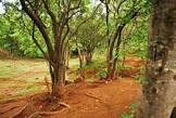
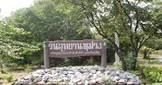
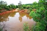
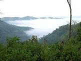
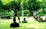
วนอุทยานพุม่วง ข้อมูลทั่วไป วนอุทยานพุม่วง อยู่ในท้องที่ตำบลจระเข้สามพัน อำเภออู่ทอง จังหวัดสุพรรณบุรี อยู่ในเขตป่าสงวนแห่งชาติป่าเขาตะโกปิดทองและป่าเขาเพชรน้อย มีเนื้อที่ประมาณ1,725 ไร่ โดยกรมป่าไม้ได้ประกาศจัดตั้งเป็นวนอุทยานเมื่อวันที่ 26 ธันวาคม 2527 ลักษณะภูมิประเทศ เป็นภูเขาหลายลูกติดต่อกันส่วนใหญ่เป็นหิน บริเวณตอนกลางเป็นที่ราบ ความสูงของพื้นที่ 180-245 เมตร และมีสถานที่ประวัติศาสตร์เกี่ยวกับวรรณคดีอยู่บริเวณเชิงเขา ลักษณะภูมิอากาศ สภาพอากาศแบ่งออกได้เป็น 3 ฤดู คือ ฤดูฝนเริ่มตั้งแต่เดือนมิถุนายนถึงตุลาคม ฤดูหนาวเริ่มตั้งแต่เดือนพฤศจิกายนถึงมกราคม และฤดูร้อน เริ่มตั้งแต่เดือนกุมภาพันธ์ถึงพฤษภาคม พืชพรรณและสัตว์ป่า เป็นป่าเบญจพรรณ พันธุ์ไม้ที่พบได้แก่ ขี้หนอน กระเช้า ตะโก พุด โมกมัน มะกอกป่า มะม่วงหัวแมลงวัน กระพี้จั่น ปรง จันทน์ขาว เป็นต้น สัตว์ป่าที่พบได้แก่ ไก่ป่า กระรอก กระแต กระต่ายป่า หมาป่า อีเห็น และนกชนิดต่างๆ พุม่วง โบราณสถาน เช่น ฐานวิหารศิลาแลง ถ้ำเสือ และคอกช้างดินสมัยทวาราวดี ในฤดูฝนจะมีน้ำตกพอสมควรอยู่ถึงสามชั้น มีทิวทัศน์สวยงาม มีสถานที่น่าสนใจเกี่ยวกับภูมิศาสตร์และประวัติศาสตร์ เรื่องขุนช้าง-ขุนแผน สถานที่ติดต่อ วนอุทยานพุม่วง ต.จรเข้สามพัน อ. อู่ทอง จ. สุพรรณบุรี 71170 โทรศัพท์ 0 3221 1025 โทรสาร 0 3221 1025 อีเมล reserve@dnp.go.th การเดินทาง รถยนต์ เดินทางตามทางหลวงหมายเลข 324 ถึงทางแยกไปอำเภอบ่อพลอยจะพบป้ายชี้ทางเข้าวนอุทยานพุม่วง แล้วเลี้ยวไปตามถนนคอนกรีตระยะทาง 700 เมตร และถนนลูกรังอีก 800 เมตร ก็จะถึงวนอุทยานพุม่วง
![]()
![]()
Phu Muang Forest Park
![]()
General Information Phu Muang Forest Park located in Chorakhe Samphan Sub District, U Thong District, Suphan Buri Province, situated in Pah Khao Takoh Pid Thong and Pah Khao Petch Noi National Reserved Forest, covered the area of approximated 1,725 rais. The Royal Forest Department declared this forest Park on December 26, 1984.
![]()
Topography It’s mountain range mostly consisting of stone mountains. Its central area is plain, about 180-245 metres above mean sea level. Literally historical site situated on the foothill.
![]()
Climate It's climate pattern can be divided into 3 seasons: rainy season started from June to October, winter started from November to January, and summer started from February to May.
![]()
Flora and Fauna It’s the Mixed Deciduous Forest. Flora found are Schoepfia sp., Aristolochia sp., Diospyros sp., Gardenia collinsae, Wrightia tomentosa, Spondias pinnata, Buchanania latifolia, Millettia brandisiana, Cycas circinalis, Diospyros decandraetc.
![]()
Fauna found are jungle fowl, squirrel, common treeshrew, jungle rabbit, wolf, palm civet and various bird species.
![]()
Phu Muang Historical sites found are laterited Buddhist Assembly Hall, Tham Sua (Tiger Cave) and Dhavaravhadi Elephant Corral. It’s an interesting geographical and historical place of Thai literature entitled Khun Chang-Khun Phan. During the rainy season, moderated amount of water filled the 3 layers-waterfall. It's Splendid view.
![]()
Contact Address Phu Muang Forest Park Chorakhe Samphan Sub-district, Amphur U Thong Suphanburi Thailand 71170Tel. 0 3221 1025 Fax 0 3221 1025 E-mail reserve@dnp.go.th How to go? By Car You can take the Highways no. 324 to the junction led to Boh Ploy District. Then you will find the sign indicated the direction to Phu Muang Forest Park. After that please take a turn to 700 metres long concrete road and follow with 800 metres rouge road to the forest park.
![]()
![]()
![]()
![]()
Latitude : 14.355046260806121, Longitude : 99.85530929723159
View Larger Map

View On Google Map
Edit Data
Images
-
วนอุทยานพุม่วง Phu Muang Forest Park
-
วนอุทยานพุม่วง Phu Muang Forest Park
-
วนอุทยานพุม่วง Phu Muang Forest Park
-
วนอุทยานพุม่วง Phu Muang Forest Park
-
วนอุทยานพุม่วง Phu Muang Forest Park
-
วนอุทยานพุม่วง Phu Muang Forest Park