Attraction อุทยานแห่งชาติน้ำตกพาเจริญ Pha Charoen National Park : ตาก
ข้อมูลทั่วไป น้ำตกพาเจริญเป็นน้ำตกหินปูนที่สวยงามด้วยชั้นน้ำตกที่ไหลลดหลั่นลงมาเป็นชั้นเล็กชั้นน้อยจำนวนมาก และตั้งอยู่ริมทางหลวงไม่ไกลจากเมืองแม่สอด จึงเป็นจุดที่นิยมแวะมาท่องเที่ยวและพักผ่อน อยู่ในความดูแลของอุทยานแห่งชาติน้ำตกพาเจริญ ซึ่งครอบคลุมพื้นที่ใน อำเภอแม่สอด และอำเภอพบพระ จังหวัดตาก ประกอบไปด้วยป่าที่อุดมสมบูรณ์ พื้นที่เป็นภูเขาสูงสลับซับซ้อนเป็น แหล่งต้นน้ำลำธาร และยังเป็นต้นกำเนิดของห้วยแม่ละเมา มีเนื้อที่ประมาณ 534,375 ไร่ หรือ 855 ตารางกิโลเมตร
อุทยานแห่งชาติน้ำตกพาเจริญ Pha Charoen National Park
![]()
![]()
ด้วยกองอุทยานแห่งชาติ กรมป่าไม้ ได้จัดตั้งวนอุทยานน้ำตกพาเจริญ ในเขตพื้นที่ป่าสงวนแห่งชาติป่าแม่สอด ท้องที่อำเภอพบพระ จังหวัดตาก ตั้งแต่เดือนกุมภาพันธ์ 2535 ประกอบด้วยกรมป่าไม้ได้ พิจารณาแล้ว เนื่องจากปัจจุบันพื้นที่ป่าบริเวณต่างๆ กำลังถูกทำลาย และยึดถือครอบครองเป็นจำนวนมาก กรมป่าไม้ได้มีคำสั่งที่ 937/2536 ให้นายธารากร อุดมธรรม เจ้าพนักงานป่าไม้ 5 กองอุทยานแห่งชาติ ปฏิบัติงานประจำและทำหน้าที่หัวหน้าวนอุทยานน้ำตกพาเจริญ จังหวัดตาก ไปดำเนินการสำรวจเพิ่มเติมและจัดตั้งพื้นที่ป่าบริเวณวนอุทยานน้ำตกพาเจริญ ป่าสงวนแห่งชาติป่าแม่ละเมา ป่าสงวนแห่งชาติป่าแม่สอด ป่าสงวนแห่งชาติป่าช่องแคบ และป่าแม่โกนเกน ท้องที่จังหวัดตาก และพื้นที่ป่าบริเวณใกล้เคียงที่มีสภาพเหมาะสมเป็นอุทยานแห่งชาติ จากรายงานการประชุมคณะกรรมการอุทยานแห่งชาติ เมื่อวันที่ 8 พฤศจิกายน 2537 เรื่องการจัดตั้งวนอุทยานน้ำตกพาเจริญ จังหวัดตาก ให้เป็นอุทยานแห่งชาติน้ำตกพาเจริญ ในพื้นที่ป่าสงวนแห่งชาติป่าแม่สอด ในท้องที่ตำบลด่านแม่ละเมา ตำบลพะวอ ตำบลธาตุผาแดง ตำบลแม่กุ ตำบลแม่ตาว ตำบลมหาวัน อำเภอแม่สอด ตำบลช่องแคบ ตำบลพบพระ ตำบลคีรีราษฎร์ อำเภอพบพระ จังหวัดตาก มีสภาพป่าที่สมบูรณ์และมีจุดเด่นทางธรรมชาติที่สวยงามเหมาะสมที่จะจัดตั้งให้เป็นอุทยานแห่งชาติ
![]()
ลักษณะภูมิประเทศ พื้นที่ส่วนใหญ่เป็นภูเขาสลับซับซ้อนวางตัวไปตามแนวเหนือใต้ มีพื้นที่ราบเล็กน้อยตามเขตลำน้ำ ยอดเขาสูงเด่นในพื้นที่มีดอยป่าตาล ดอยเด่นกระทิง ดอยหลวง ดอยหมากหมื่น เขาลมพักเย็น เป็นส่วนหนึ่งของเทือกเขาถนนธงชัย มียอดเขาที่สูงที่สุดอยู่ทางทิศใต้สูงถึง 1,765 เมตร จากระดับน้ำทะเล พื้นที่ตั้งอยู่ในเขตมรสุมตะวันตกเฉียงใต้ ทำให้มีฝนตกชุกตลอดปี จึงเป็นพื้นที่ต้นน้ำลำธาร ต้นกำเนิดของห้วยแม่ละเมา ห้วยอุ้มเปี้ยม ที่มีทิศทางการไหลของน้ำจากทิศใต้สู่ทิศเหนือ มีลำห้วยหลายสายที่มีต้นกำเนิดจากพื้นที่นี้ไหลสู่พื้นที่เกษตรกรรมของอำเภอแม่สอด อำเภอพบพระ เช่น ห้วยแม่สอด ห้วยแม่ดาว ห้วยผักกูด ฯลฯ
![]()
พืชพรรณและสัตว์ป่า สภาพป่าทั่วไปยังคงสมบูรณ์ ส่วนมากเป็นป่าเบญจพรรณ และป่าบางส่วนเป็นป่าสนเขา พันธุ์ไม้ที่สำคัญ ได้แก่ สัก ยาง ประดู่ สนเขา มะม่วงป่า เต็งรัง เหียง ตะเคียนหนู ตะเคียนทอง มะค่าโมง มะค่าแต้ แดง ยมหอม ยมหิน ฯลฯ ไม้พื้นล่าง เช่น เฟิร์น บอนป่า กระเจียวป่า เป็นต้น
![]()
สัตว์ป่า จากการสำรวจพบว่ามีหลายชนิดเช่น กระทิง กวาง เก้ง หมี นกชนิดต่างๆ เสือ หมูป่า ไก่ป่า ไก่ฟ้า งูชนิดต่าง ๆ เม่น อีเห็น ชะนี ลิง กระจง หมาป่า ฯลฯ ทั้งนี้เนื่องจากพื้นที่ทางใต้ติดกับอุทยานแห่งชาติ คลองวังเจ้า เขตรักษาพันธุ์สัตว์ป่าอุ้มผาง และสหภาพพม่า
![]()
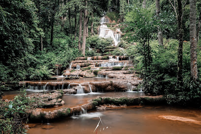
น้ำตกพาเจริญ เป็นน้ำตกหินปูนเกิดจากห้วยน้ำนัก มีน้ำตลอดปี มีถึง 97 ชั้น สภาพป่าบริเวณน้ำตก อากาศเย็นสบายห่างจากทางหลวงจังหวัดหมายเลข 1090 เพียง 700 เมตร กม.ที่ 37 ตำบลช่องแคบ อำเภอพบพระ จังหวัดตาก ชื่อของน้ำตกตั้งตามชื่อของผู้ก่อการร้ายคอมมิวนิสต์ซึ่งเป็นผู้พบน้ำตกคนแรกนามว่า สหายพา ต่อมาชาวบ้านเข้ามาอาศัยในพื้นที่บริเวณนี้ จนเกิดเป็นชุมชนที่เจริญขึ้น จึงต่อคำว่าเจริญท้ายชื่อน้ำตกเป็นน้ำตกพาเจริญ นอกจากนี้ยังมีเรียกน้ำตกนี้อีกชื่อหนึ่งว่า น้ำตกร่มเกล้า 97 ชั้น
![]()
น้ำตกสายฟ้า มีชื่อเรียกอีกชื่อหนึ่งว่า น้ำตกสายรุ้ง อยู่ท้องที่หมู่ที่ 4 ตำบลพบพระ อำเภอพบพระ จังหวัดตาก มีถนนเข้าถึง ซึ่งสามารถเข้าชมได้เฉพาะฤดูแล้งและฤดูหนาวมีต้นกำเนิดจากห้วยน้ำนักมีน้ำตลอดปี น้ำตกมีความสวยงามตามธรรมชาติและละอองน้ำกระทบแสงแดดเป็นรุ้งกินน้ำ
![]()
บ่อน้ำร้อนพาเจริญ เป็นบ่อน้ำร้อนตามธรรมชาติ อุณหภูมิของบ่อน้ำในบ่อวัดได้ 60 องศาเซลเซียส มีถึง 3 บ่อ ในบริเวณใกล้เคียงกัน ตั้งอยู่ที่หมู่ 4 อำเภอพบพระ ในเขตป่าแม่สอด เป็นแหล่งท่องเที่ยวที่ติดกับถนน รพช. สายพบพระ-ช่องแคบ สามารถเที่ยวชมได้ตลอดปี และมีห้วยน้ำนักไหลผ่านด้านหลังบ่อน้ำร้อน
![]()
น้ำตกป่าหวาย เป็นน้ำตกหินปูนเกิดจากลำห้วยหวายมีน้ำไหลตลอดปีมีจำนวนชั้นมากกว่า 100 ชั้น สภาพป่าบริเวณน้ำตกสมบูรณ์มาก มีไม้ตั้งแต่ขนาดกลางจนถึงขนาดใหญ่ เนื่องจากพันธุ์ไม้บริเวณน้ำตกมีไม้หวายจำนวนมาก จึงเรียกน้ำตกป่าหวาย เป็นส่วนหนึ่งของต้นน้ำอุ้มเปี่ยมอยู่ใน ท้องที่ หมู่ 3 ตำบลคีรีราษฎร์ อำเภอพบพระ จังหวัดตาก ปัจจุบันทางอำเภอพบพระได้พัฒนาทางเข้าชมน้ำตกป่าหวายจากทางหลวงจังหวัดหมายเลข 1090 ตรงกิโลเมตรที่ 40 เข้าถึงหมู่บ้านป่าหวายเป็นระยะทาง 17 กิโลเมตร และจากหมู่บ้านป่าหวายถึงน้ำตกป่าหวาย อีก 3 กิโลเมตร นับว่าเป็นน้ำตกที่สวยงามและสภาพป่าที่อุดมสมบูรณ์
![]()
น้ำตกห้วยตะปูเคาะ เป็นน้ำตกที่สวยงามอีกแห่งหนึ่งอยู่ทางทิศเหนือของป่าแม่สอด ห่างจากถนนหลวงสาย 105 บริเวณกิโลเมตรที่ 33 ประมาณ 1 กิโลเมตร เกิดจากห้วยตะปูเคาะ ที่มีต้นน้ำอยู่บริเวณดอยบุญตา พื้นที่นิคมชาวเขาดอยมูเซอร์ น้ำตกหลายชั้นแตกต่างกันไป มีน้ำไหลตลอดปี แต่สวยงามมากในฤดูฝน สภาพบางช่วงยังอุดมสมบูรณ์อยู่มีไม้ใหญ่ขึ้นอยู่จำนวนมาก เป็นแหล่งต้นน้ำของห้วยแม่ละเมาแห่งหนึ่ง และบางส่วนถูกแผ้วถางใช้เป็นที่ทำการเกษตรอยู่ในท้องที่หมู่ 5 ตำบลแม่ละเมา อำเภอแม่สอด ปัจจุบันไม่เป็นที่รู้จักแต่สามารถพัฒนาให้เป็นแหล่งท่องเที่ยวได้ เพราะอยู่ไม่ห่างจากถนนมากนัก ใกล้จุดชมวิวถนนหลวงสาย 105 ตรงกม. ที่ 33 และร้านค้าชาวเขาดอยมูเซอร์ การเดินเที่ยวชมสะดวกมาก เนื่องจากมีทางเดินชาวเขาเผ่ามูเซอร์
![]()
จุดชมทิวทัศน์ดอยเกี๊ยะ เป็นจุดสูงสุดบริเวณชายแดนไทย-พม่า สำหรับชมทัศนียภาพของแม่น้ำเมย และผืนป่าอันอุดมสมบูรณ์ทั้งในฝั่งไทยและพม่า ส่วนในฤดูหนาวจะมีทะเลหมอกสวยงาม
![]()
น้ำตกนางครวญ เป็นน้ำตกหินปูนขนาดกลางซึ่งไหลลดหลั่นลงมาเป็นชั้นๆ การเดินทางจากอำเภอแม่สอดใช้ทางหลวงจังหวัดหมายเลข 1090 แล้วแยกเข้าทางหลวงจังหวัดหมายเลข 1206 ไปทางอำเภอพบพระ ประมาณ 12 กิโลเมตร จะถึงน้ำตก
![]()
![]()
สถานที่ติดต่อ อุทยานแห่งชาติน้ำตกพาเจริญ หมู่ 6 ต.ช่องแคบ อ. พบพระ จ. ตาก 63160
![]()
![]()
การเดินทาง รถยนต์ จากอำเภอแม่สอด ใช้ทางหลวงจังหวัดหมายเลข 1090 ถึง กม. ที่ 37 มีทางแยกเข้าไปประมาณ 700 เมตร จะถึงที่ทำการอุทยานแห่งชาติ
![]()
![]()
รถโดยสารประจำทาง เดินทางโดยรถ บขส. จากกรุงเทพฯ-แม่สอด โดยอาศัยทางเดินหมายเลข 105 ทางตอนเหนือของ ทางหลวงหมายเลข 1090 ทางทิศตะวันตก และทิศใต้ก็จะผ่านสถานที่ท่องเที่ยวแหล่งต่าง ๆ ของอุทยานแห่งชาติ น้ำตกเจริญ
![]()
![]()
สถานที่กางเต็นท์/เต็นท์ มีพื้นที่กางเต็นท์ พร้อมห้องน้ำ-ห้องสุขารวม ไว้ให้บริการ ท่านสามารถนำเต็นท์มากางเอง หรือติดต่อขอใช้บริการเต็นท์ของอุทยานแห่งชาติ ซึ่งมีค่าบริการอยู่หลายอัตราขึ้นอยู่กับชนิด ขนาดของเต็นท์ และอุปกรณ์ประกอบอื่นๆ
![]()
![]()
General Information Nam Tok Pacharoen National Park is situated in an approximate area of 855 square kilometers or 534,375 rai, covering the areas of Mae-sod National Conserved Forest in Tambol Daan Mae-lamoh, Tambol Pa-oar, Tambol Pratad Pah-daeng, Tambol Mae-ku, Tambol Mae-tao, Tambol Mahawan of Mae-sod District, Tambol Chong-kaeb, Tambol Phob-phra, Tambol Kirirat of Phob-phra District, Tak Province. The geographical features of the National Park consist of high mountains and virgin forests, which are regarded as sources of rivers, gullies, and Huai Mae-lamoh.
![]()
![]()
The geographical features of the National Park consist of high mountains, extending northwards, and small plains along the rivers. The towering mountaintops within the area of the National Park include Doi Pah-tan, Doi Den-krating, Doi Luang, Doi Mhak-muen, Khao Lom-pudyen, which are parts of Thanon Thongchai Mountains. The highest mountaintop (1,765 meters above the sea level) is situated in the south of the National Park. Since the area of the National Park is affected by the southwestern monsoon and there are heavy rains throughout the year, the area consequently becomes the source of major gullies including Huai Mae-lamoh, Huai Mae-piam, Huai Mae-sod, Huai Mae-tao, Huai Pakkood, etc., flowing northwards into the agricultural areas of Mae-sod District and Phob-phra District.
![]()
![]()
Climate Since the area of the National Park is affected by the southwestern monsoon, the weather at the National Park is considerably cool and can be divided into 3 seasons including summer (March-May), when the weather is not extremely hot because of the altitude and breezy condition of the area; the rainy season (June-October), when there are heavy and continuous rains throughout the season; and winter (November-February) when the weather is not much cold with the lowest temperature of 6ฐC. The rainfall within the area of the National Park is between 1,500-2,000 mm/year.
![]()
![]()
Flora and Fauna There are various kinds of forests within the areas of the National Park, including mixed forests and pinery. Major plants include teaks, rubber trees, Leguminosae (Pradoo), pines, Mangifera Caloneura Kurz (wild mango), Shorea Obtusa Wall., Dipterocarpus Intricatus (Hiang), Anogeissus Acuminata Wall. (Takien Noo), Ironwood, Afzelia Xylocarpa Roxb., Sindora Siamensis Teijsm. Ex Miq. (Maka-tae), Xylia Xylocarpa (redwood plants), Indian Mahogany, Chukrasia Venlutina (Yom-hin), etc.; and lower plants include ferns, Colocasia Esculenta, Curcuma Sparganifolia Gagnep., etc.
![]()
![]()
Wild animals found in the National Park include gaur, deer, Muntiacus Muntjak, birds, tigers, wild boars, red jungle fowls, pheasants, snakes, porcupines, masked palm civets, gibbons, monkeys, mouse deer, wolves, etc., thus, because the southern part of the National Park is close to Klong Wangjao National Park, Oumphang Sanctuary, and the Union of Myanmar.
![]()
![]()
Pacharoen Waterfall Pacharoen Waterfall is a 97-step limestone waterfall, situated in the area of Mae-sod Forest with the flowing water throughout the year. The Waterfall originated from Huai Nam-nuk. The weather is cool and breezy. At present, the National Park’s office has provided officials and staff to provide convenience and safety for tourists, including temporary parking space (which can be used in particular seasons) and camping sites, etc. The National Park is now one of the tourist attractions of Phobphra District and Mae-sod District, and become popular among Thai and foreign tourists.
![]()
![]()
Saifa Waterfall Saifa Waterfall is situated in Moo 4, Tambol Phobphra, Phobphra District, Tak Province. The Waterfall can be accessed by car only in the dry season and in winter. The Waterfall originated from Huai Nam-nuk with the flowing water throughout the year. The Waterfall is very beautiful when rainbows occur.
![]()
![]()
PacharoenHot Spring There are 3 natural hot springs with the temperature of 60๐C, situated in the area of Mae-sod Forest, Moo 4, Phobphra District, Tak Province. At present, Phobphra District has developed the Hot Spring as a tourist attraction and also provided roadside pavilions close to Ror.Por.Chor.Road (Phobphra-Chongkaeb)
![]()
![]()
The Hot Spring can be accessed by laterite road throughout the year. And there is Huai Nam-nuk passing the back of the Hot Spring.
![]()
![]()
Bawai Waterfall Bawai Waterfall is a 100-step limestone waterfall, originating from Huai Wai with the flowing water throughout the year. The Waterfall is situated in virgin forest consisting of medium-sized/large plants. The Waterfall is called “Bawai Waterfall” because there are a lot of Calamus Caesius within the area. At present, Phobphra District has developed access roads to the Waterfall (from Highway No.1090 km40 to Ban Bawai for approximately 17 kilometers long and from Ban Bawai to the Waterfall for approximately 3 kilometers long). The Waterfall is very beautiful and can be developed as a tourist attraction.
![]()
![]()
Huai Tapu-kor Waterfall Huai Tapu-kor Waterfall is another beautiful waterfall situated in the north of Mae-sod Forest (approximately 1 km away from Highway No.105 km33). The Waterfall originated from Huai Tapu-kor of Doi Boonta within the area of Mu-seur Tribesman Settlement. The Waterfall is a multi-step waterfall with the flowing water throughout the year. The Waterfall is very beautiful in the rainy season. And there are virgin forests and large plants in some areas of the Waterfall, which are water sources of Huai Mae-lamao of Mae-sod District. At present, the Waterfall is not well known but it can be developed as a tourist attraction because the Waterfall is not too far from the main road and it is close to a sightseeing spot on Highway No.105 km33, and to the Mu-seur Tribesmen’s shop. It is very convenient for tourists to visit the Waterfall since there is a jungle route used by Mu-seur Tribesmen.
![]()
![]()
Contact Address Namtok Pha Charoen National Park Mu 6, Chong kaeb Sub-district, Amphur Phob Phra Tak Thailand 63160
![]()
![]()
How to go? By Bus and car You may take a bus of the Transport Company Limited (Bangkok-Maesod) and the route No.105 in the north of Highway No.1090 to the tourist attractions of the National Park.
![]()
![]()
![]()
![]()
![]()
Latitude : 16.502167872873446, Longitude : 98.75274446181774
View Larger Map

View On Google Map
Edit Data
Images
-
อุทยานแห่งชาติน้ำตกพาเจริญ Pha Charoen National Park
-

อุทยานแห่งชาติน้ำตกพาเจริญ Pha Charoen National Park
-

อุทยานแห่งชาติน้ำตกพาเจริญ Pha Charoen National Park
-

อุทยานแห่งชาติน้ำตกพาเจริญ Pha Charoen National Park
-

อุทยานแห่งชาติน้ำตกพาเจริญ Pha Charoen National Park
-

อุทยานแห่งชาติน้ำตกพาเจริญ Pha Charoen National Park