Attraction วนอุทยานน้ำตกหัวแม่คำ Namtok Hua Mae Kham Foerst Park : เชียงราย
ข้อมูลทั่วไป วนอุทยานน้ำตกหัวแม่คำ อยู่ในท้องที่ตำบลแม่สลองใน อำเภอแม่ฟ้าหลวง จังหวัดเชียงราย อยู่ในเขตป่าสงวนแห่งชาติป่าน้ำแม่คำ ป่าน้ำแม่สลอง ป่าน้ำแม่จันฝั่งซ้าย มีเนื้อที่ประมาณ 3,500 ไร่ กรมป่าไม้ได้ประกาศจัดตั้งเมื่อวันที่ 20 พฤศจิกายน 2541
วนอุทยานน้ำตกหัวแม่คำ Namtok Hua Mae Kham Foerst Park
![]()
![]()
ลักษณะภูมิประเทศ เป็นเทือกเขาสูงสลับกันเป็นทอด ๆ มีเทือกเขาสูงซึ่งเป็นจุดแบ่งเขตแดนระหว่างไทยกับสหภาพพม่า สูงจากระดับน้ำทะเลปานกลางประมาณ 1,300-1,700 เมตร มีความลาดชันเฉลี่ยทั่วพื้นที่ประมาณ 35-45 เปอร์เซ็นต์ ส่วนใหญ่เป็นภูเขาที่มีดินอยู่ชั้นบนและมีหินโผล่ สำหรับบริเวณน้ำตกจะมีหินขนาดใหญ่บางเล็กบ้างซ้อนทับกันอย่างสวยงาม
![]()
![]()
ลักษณะภูมิอากาศ เป็นแบบมรสุมเมืองร้อนคือ ได้รับอิทธิพลจากลมมรสุมตะวันตกเฉียงใต้ในช่วงฤดูฝนและลมตะวันออกเฉียงเหนือในช่วงฤดูหนาว แบ่งออกเป็น 3 ฤดู คือฤดูร้อน มีลักษณะร้อนชื้นในช่วงเดือนมีนาคม - พฤษภาคม ฤดูฝน มีลักษณะที่ฝนตกแล้วมีลมกรรโชกแรงอยู่ในช่วงเดือนมิถุนายน - กันยายน ฝนจะตกมากในช่วงเดือนกรกฎาคม สิงหาคม ไปจนถึงเดือนตุลาคม ฤดูหนาวมีลักษณะถึงหนาวจัด อยู่ในระหว่างเดือนตุลาคม - กุมภาพันธ์
![]()
![]()
พืชพรรณและสัตว์ป่า เป็นป่าดิบเขา บริเวณบนภูเขาได้ผ่านการทำการเกษตรมาแล้วหลายปีมีต้นไม้ขึ้นไม่หนาแน่น ส่วนบริเวณที่เป็นที่โล่งจะมีดอกบัวตองขึ้นอยู่เต็มพื้นที่ สำหรับบริเวณหุบเขาซึ่งมีลำห้วยและมีน้ำไหลตลอดปีจะมีสภาพป่าที่อุดมสมบูรณ์ มีพันธุ์ไม้ทั้งยืนต้นและไม้ชั้นล่าง เช่น เฟิร์น ไลเคน บอน มะหูด หญ้าชนิดต่าง ๆ รวมถึง ลูกไม้ ชนิดพันธุ์ไม้ยืนต้นที่พบได้ ก่อแป้น แดงน้ำ เสี้ยวดอกขาว ก่อเดือย มะไฟป่า ไผ่ป่า มะหลอด ประดู่ กาสลองคำ เงาะป่า ปอเลียง มะขามป้อม แคหางค่าง ตะแบกใหญ่ ตะเคียนทอง มะเดื่อ ข่อย ปอกระสา กระพี้จั่น ทองหลาง
![]()
![]()
สัตว์ป่าที่พบได้แก่ อีเห็น กระต่าย และนกชนิดต่าง ๆ เป็นต้น
![]()
![]()
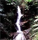
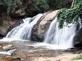
น้ำตกและทุ่งบัวตอง น้ำตกและทุ่งบัวตอง บ้านหัวแม่คำ อยู่บนยอดเขาสูงจากระดับน้ำทะเล 1,400 เมตร เนื่องจากเป็นพื้นที่สูงจึงทำให้มีน้ำตกที่มีน้ำไหลตลอดปีจากห้วยสาขาของน้ำแม่คำ โดยเฉพาะบริเวณห้วยโป่งหลีมีน้ำตก 2 ชั้น สูงประมาณชั้นละ 5-10 เมตร และบริเวณห้วยแม่คำจะมีน้ำตกตามลำห้วยประมาณ 20 จุด สูงประมาณ 1-5 เมตร นอกจากนั้นบริเวณภูเขาซึ่งล้อมรอบหมู่บ้านมีดอกบัวตองขึ้นอยู่ และจะบานสะพรั่งในช่วงฤดูหนาว
![]()
![]()
สถานที่ติดต่อ วนอุทยานน้ำตกหัวแม่คำ ต.แม่สลองใน อ. แม่ฟ้าหลวง จ. เชียงราย 57110 โทรศัพท์ 0 5371 4914 โทรสาร 0 5371 1961
![]()
![]()
การเดินทาง รถยนต์ เดินทางจากอำเภอเมืองจังหวัดเชียงรายเป็นถนนลาดยางสี่เลน ถึงอำเภอแม่จัน ระยะทาง 30 กิโลเมตร และจากทางแยกแม่จัน-แม่สลอง เป็นทางลาดยางลาดชันตามแนวไหล่เขาสวยงามมากถึงทางแยกเข้าบ้านเทอดไทย ระยะทาง 23 กิโลเมตร จากทางแยกถึงบ้านเทอดไทยอีก 13 กิโลเมตร ผ่านบ้านนาโต่ บ้านปางมะหันจนถึงวนอุทยานน้ำตกหัวแม่คำ ระยะทาง 37 กิโลเมตร รวมระยะทางจากอำเภอเมือง จังหวัดเชียงรายถึงวนอุทยานน้ำตกหัวแม่คำประมาณ 103 กิโลเมตร
![]()
![]()
General Information Hua Mae Kum Waterfalls Forest Park is located in Mae Salong Nai Sub-District, Mae Fah Luang District, Chiang Rai Province. It situated in Pa Naam Mae Kum, Pa Naam Mae Salong and the left side of Pa Naam Mae Chan National Reserves Forest covered the area of approximately 3,500 rais. The Royal Forest Department declaved this forest park on November 20, 1998
![]()
Topography The area is mountainous with a very high Mountain range setting apart Thailand and Union of Myanmar. The area is 1,300-1,700 meters above mean sea level and an average slope all round of approximately 35-45%. Mountains in the area are quite rocky, however, covered by soils, where by the area around the waterfalls consists of magnificent layers of large and small rocks.
![]()
Climate Tropical Monsoon with influence from South-Westerly wind during rainy seasons and North-Easterly wind during winter. There are 3 seasons altogether in this area – summer from March to May (hot & humid), rainy season from June to September (wet & windy) and winter from October to February (very cold).
![]()
Flora and Fauna The area is generally covered in primary forest. There are not many trees on the mountains since agricultural activities had been carried out for many years. Around the open space, Bua Tong flowers can be found. In the valley, there are creeks with all year round water flows with thick and lush forest consisting of many trees perennials and ground covering plants such as ferns, liceuse grass and elephant’s ear. Perennials found are figs, ironwood, bamboos, evergreen chinkapin, bauhinia, ebony, jute, paper mulberry, coral tree, emblic leaf flower, sesban and toothbrush tree.
![]()
Common wildlife are civet, wild hare, and birds.
![]()
Waterfalls and Bua Tong fields Waterfalls and Bua Tong fields is situated on the mountain top 1,400 meters above mean sea level. Because the area is very high, water flows throughout the year from Sub-Cuek of Mae Kum River originating from Mae Kum River. There is also another 2 storey high waterfalls around Poang Lee Creek area, with each storey being approximately 5-10 meters high. Along Mae Kum Creek, there are approximately 20 other waterfalls, each at around 1-5 meters in height. Besides the waterfalls, there are also Bua Tong flowers all around the mountain which will fully bloom in the winter.
![]()
![]()
Contact Address Namtok Hua Mae Kham Foerst Park Mae Salong Nai Sub-district, Amphur Mae Fa Luang Chiang Rai Thailand 57110Tel. 0 5371 4914 Fax 0 5371 1961 E-mail reserve@dnp.go.th
![]()
How to go? By Car From Muang District, Chaing Rai Province to Mae Chan District (30 kilometers). From Mae Chan-Mae Salong Junction to the Junction leading to Baan Terdthai (23 kilometers up hills). Another 13 kilometers to Baan Terdthai itself, then, another 37 kilometers to Hua Mae Kum Waterfalls Forest Park via Baan Na Doh and Baan Paang Mahan. Total distance from Muang District, Chiang Rai province to Hua Mae Kum Waterfalls Forest Park is approximately 103 kilometers.
![]()
![]()
![]()
![]()
Latitude : 20.379652530952274, Longitude : 99.4757213974451
View Larger Map

View On Google Map
Edit Data
Images
-
วนอุทยานน้ำตกหัวแม่คำ Namtok Hua Mae Kham Foerst Park
-

วนอุทยานน้ำตกหัวแม่คำ Namtok Hua Mae Kham Foerst Park
-
วนอุทยานน้ำตกหัวแม่คำ Namtok Hua Mae Kham Foerst Park
-

วนอุทยานน้ำตกหัวแม่คำ Namtok Hua Mae Kham Foerst Park
-

วนอุทยานน้ำตกหัวแม่คำ Namtok Hua Mae Kham Foerst Park
-

วนอุทยานน้ำตกหัวแม่คำ Namtok Hua Mae Kham Foerst Park