Attraction ดอยอินทนนท์ Doi Inthanon National Park : เชียงใหม่
แต่เดิมดอยอินทนนท์มีชื่อว่า “ดอยหลวง” หรือ “ดอยอ่างกา” คำว่า ดอยหลวง หมายถึง ภูเขาที่มีขนาดใหญ่ ส่วนที่เรียกว่าดอยอ่างกานั้น มีเรื่องเล่าว่า ห่างจากดอยอินทนนท์ไปทางทิศตะวันตก 300 เมตร มีหนองน้ำอยู่แห่งหนึ่งลักษณะเหมือนอ่างน้ำ แต่ก่อนนี้มีฝูงกาลงไปเล่นน้ำกันมากมายจึงเรียกว่า อ่างกา ต่อมาจึงรวมเรียกว่า “ดอยอ่างกา” เมื่อครั้งที่พื้นที่ป่าไม้ทางภาคเหนือ ยังอยู่ในความควบคุมของเจ้าผู้ครอบครองนครต่าง ๆ นั้นในสมัยพระเจ้าอินทรวิชยานนท์เป็นเจ้าผู้ครองนครเชียงใหม่ พระองค์เป็นผู้ที่เห็นความสำคัญของป่าไม้เป็นอันมาก โดยเฉพาะ “ดอยหลวง” พระองค์มีความหวงแหนเป็นพิเศษ ขณะที่ยังมีพระชนม์อยู่ได้สั่งไว้ว่า หากสิ้นพระชนม์ไปแล้วก็ขอให้แบ่งเอาอัฐิส่วนหนึ่งไปบรรจุไว้บนยอดดอยหลวงด้วย ต่อมาคำว่าดอยหลวงก็ถูกเปลี่ยนเป็น “ดอยอินทนนท์” ตามพระนามของเจ้าผู้ครองนครนั้น และเมื่อขึ้นไปบนยอดเขาสูงนี้จะเห็นสถูปบรรจุพระอัฐิของพระเจ้าอินทรวิชยานนท์ประดิษฐานอยู่
ดอยอินทนนท์ Doi Inthanon National Park
![]()
อุทยานแห่งชาติดอยอินทนนท์ มีพื้นที่ทั้งหมดประมาณ 482 ตารางกิโลเมตร ครอบคลุมพื้นที่ อ.แม่แจ่ม อ.จอมทอง และอ.สันป่าตอง จ.เชียงใหม่ สภาพภูมิประเทศเป็นเทือกเขาสลับซับซ้อนมีความสูงตั้งแต่ 400-2,565 เมตรจากระดับน้ำทะเล สภาพป่ามีหลายประเภททั้ง ป่าเต็งรัง ป่าเบญจพรรณ ป่าดิบแล้งและป่าดิบเขา บนยอดดอยยังพบพืชจากเขตอบอุ่น เช่น กุหลาบพันปี บัวทอง ต่างไก่ป่า ฯลฯ และตามหน้าผาพบป่ากึ่งอันไพน์ ดอยอินทนนท์เป็นศูนย์รวมของนกป่าเกือบ 400 ชนิด โดยเฉพาะนกหายากหลายชนิดที่อาศัยในที่สูง เช่น นกปีกแพร นกกระทาดง นกศิวะ ฯลฯ
![]()
อุทยานแห่งชาติดอยอินทนนท์เป็นพื้นที่ต้นน้ำลำธารที่สำคัญของแม่น้ำปิง ให้กำเนิดแม่น้ำลำธารหลายสาย ที่สำคัญได้แก่ ลำน้ำแม่วาง ลำน้ำแม่กลาง ลำน้ำแม่ยะ ลำน้ำแม่หอย ลำน้ำแม่แจ่ม และลำน้ำแม่เตี๊ยะ
![]()
ลักษณะภูมิอากาศ สภาพภูมิอากาศโดยทั่วไปของพื้นที่อุทยานแห่งชาติดอยอินทนนท์ได้รับอิทธิพลจากลมมรสุมตะวันตกเฉียงใต้ที่พัดพาเอาความชุ่มชื้นและเมฆฝนเข้ามาทำให้ฝนตก และลมมรสุมตะวันออกเฉียงเหนือที่พัดมาจากประเทศจีนจะนำเอาความหนาวเย็นและความแห้งแล้งเข้ามา ทำให้เกิดฤดูกาลต่าง ๆ โดยจะมีฤดูร้อนในช่วงระหว่างเดือนมีนาคม-พฤษภาคม ฤดูฝนในช่วงระหว่างเดือนมิถุนายน-พฤศจิกายน และฤดูหนาวในช่วงระหว่างเดือนธันวาคม-กุมภาพันธ์ สลับกันไป
![]()
สัตว์ป่าในบริเวณอุทยานแห่งชาติที่นี้มีจำนวนลดลงไปมาก เนื่องจากถูกชาวเขาเผ่าต่าง ๆ ล่าเป็นอาหาร และป่าซึ่งเป็นที่อยู่อาศัยถูกถางลงมาก ทำให้สัตว์ใหญ่บางชนิดหมดไปจากป่านี้ สัตว์ที่เหลืออยู่ส่วนมากเป็นสัตว์ขนาดเล็ก เช่น กระรอก กระแตธรรมดา กระเล็นขนปลายหูสั้น อ้นเล็ก เม่นหางพวง อีเห็นข้างลาย ชะมดแผงสันหางดำ นกแซงแซวเล็กเหลือบ นกปรอดหัวสีเขม่า นกเด้าดินทุ่ง เหยี่ยว เพเรกริน ไก่ฟ้าหลังขาว นกเงือกคอแดง นกพญาไฟสีกุหลาบ กิ้งก่าหัวสีฟ้า จิ้งเหลนเรียวจุดดำ ตุ๊กแกบ้าน งูลายสอคอแดง กบห้วยสีข้างดำ เขียดหนอง อึ่งกราย คางคกเล็ก ปาดแคระฯลฯ
![]()
ปัจจุบันราชการทหารได้ตัดถนนขึ้นสู่ยอดดอยอินทนนท์ ทำให้เดินทางไปโดยรถยนต์ได้สะดวก สำหรับผู้ที่ต้องการสัมผัสธรรมชาติอย่างแท้จริงก็อาจเลือกวิธีเดินเท้า ซึ่งเป็นวิธีดั้งเดิมก่อนที่จะมีทางรถยนต์ ทางเดินที่นิยมมักเริ่มต้นจากน้ำตกแม่กลาง คืนแรกพักที่หมู่บ้านกะเหรี่ยงหรือกลางป่า คืนที่สองพักที่หมู่บ้านกะเหรี่ยงผาหม่อน คืนที่สามพักที่ปางสมเด็จ แล้วขึ้นสู่ยอดดอยอินทนนท์ ในระหว่างทางจะได้รับความเพลิดเพลินกับบรรยากาศป่าเขา และได้ศึกษาความเป็นอยู่ของชาวกะเหรี่ยงไปด้วย
![]()
จุดเด่นของอุทยานแห่งชาตินี้ คือ ยอดดอยอินทนนท์ซึ่งเป็นยอดเขาสูงสุดของประเทศ ซึ่งคนไทยส่วนมากต้องการไปสัมผัสเพื่อประวัติของชีวิต อากาศบนยอดดอยหนาวเย็นประดุจดังอยู่ในเมืองหนาว ยามฤดูหนาวจัด มีเมฆหมอกครึ้ม บรรยากาศดังกล่าวไม่อาจหาได้ในส่วนอื่นของประเทศ ต้นไม้ในบริเวณยอดดอยแปลกไปกว่าที่อื่น เพราะมีสภาพป่าประดุจดังป่าโลกล้านปี
![]()
น้ำตกแม่กลาง เป็นน้ำตกขนาดใหญ่ซึ่งมีน้ำไหลตลอดปี และมีแอ่งน้ำขนาดใหญ่ให้เล่นน้ำหลายแห่ง แต่ในช่วงฤดูฝนกระแสน้ำไหลแรงจนอาจเป็นอันตรายต่อการเล่นน้ำ น้ำตกแม่กลางอยู่ทางทิศตะวันออกของอุทยานแห่งชาติ จากถนนสายจอมทอง-ดอยอินทนนท์ ประมาณ กม.ที่ 8 ก่อนถึงด่านตรวจของอุทยานแห่งชาติ แล้วเลี้ยวซ้ายเข้าไปประมาณ 1 กิโลเมตร ก็จะถึงน้ำตกแม่กลาง สามารถเดินลัดเลาะตามเส้นทางเดินไปยังศูนย์บริการนักท่องเที่ยว ซึ่งตั้งอยู่ห่างจากน้ำตกแม่กลางประมาณ 400 เมตร ผ่านเหมืองฝายและภาพเขียนสีผาคันนา
![]()
น้ำตกแม่ยะ อยู่ทางทิศใต้ของอุทยานแห่งชาติเป็นน้ำตกขนาดใหญ่ เกิดจากลำห้วยแม่ยะ ไหลลดหลั่นลงมาถึง 30 ชั้น รวมความสูงประมาณ 260 เมตร จนกล่าวกันว่าเป็นน้ำตกที่สวยที่สุดของประเทศ ในช่วงฤดูฝนสายน้ำตกจะแผ่กว้างถึง 100 เมตร ฤดูแล้งปริมาณน้ำอาจลดน้อยลง แต่สายน้ำตกจะใสสะอาดกว่า น้ำตกแม่ยะตั้งอยู่ทางตอนใต้ของพื้นที่อุทยานแห่งชาติ เมื่อเข้าสู่ถนนสายจอมทอง-ยอดดอยอินทนนท์ ได้ประมาณ 1 กิโลเมตร จะมีทางแยกซ้ายไปอีกประมาณ 14 กิโลเมตร
![]()
น้ำตกสิริภูมิ เดิมชื่อ น้ำตกเลาลี ตามชื่อของชาวเขา ซึ่งเป็นหัวหน้าหมู่บ้านที่อยู่ใกล้น้ำตกนี้ ต่อมา ม.ร.ว.จักรทอง ทองใหญ่ เมื่อครั้งเป็นรัฐมนตรีว่าการกระทรวงเกษตรและสหกรณ์ ได้ขนานนามว่า “สิริภูมิ” เพื่อเป็นการเฉลิมพระเกียรติพระบาทสมเด็จพระเจ้าอยู่หัวและสมเด็จพระนาง-เจ้าพระบรมราชินีนาถ น้ำตกนี้อยู่ที่บ้านขุนกลาง ใกล้ กม.ที่ 31 ถนนสายจอมทอง-ดอยอินทนนท์ เป็นน้ำตก 2 สาย ที่ไหลคู่กันลงมาจากหน้าผาสูงซึ่งสามารถมองเห็นได้จากระยะไกล
![]()
น้ำตกวชิรธาร มีอีกชื่อหนึ่งเรียกว่า น้ำตกตาดฆ้องโยง เกิดจากลำห้วยแม่กลาง อยู่ประมาณหลักกม.ที่ 22 ถนนสายจอมทอง-ดอยอินทนนท์ เป็นน้ำตกขนาดใหญ่ สูงประมาณ 70-80 เมตร สายน้ำไหลตกจากหน้าผาลงสู่แอ่งน้ำเบื้องล่าง มีน้ำไหลตลอดทั้งปี ในยามที่แสงอาทิตย์ส่องกระทบละอองน้ำจะปรากฏสายรุ้งงดงามขึ้นเหนือธารน้ำ ตรงข้ามมีหน้าผาสูงชัน เรียกว่า “ผามอแก้ว” หรือภายหลังเรียกว่า ผาแว่นแก้ว
![]()
น้ำตกสิริธาร ตั้งอยู่ห่างจากตัวอำเภอเชียงใหม่ประมาณ 81 กิโลเมตร ตามเส้นทางหลวงแผ่นดินหมายเลข 108 (เชียงใหม่-ฮอด) ประมาณกิโลเมตร 58 เลี้ยวขวาเข้าสู่ถนนสายจอมทอง-ดอยอินทนนท์ ประมาณ 23 กิโลเมตร มีทางแยกเข้าไปจุดชมทิวทัศน์น้ำตกสิริธาร ต้องเดินเท้าเข้าไปอีกประมาณ 100 เมตร คดเคี้ยวไปตามความลาดชันของภูเขา
![]()
ดอยขุนกลาง บริเวณกิโลเมตรที่ 31 จะปรากฎสภาพภูมิประเทศโดยรอบจะเป็นทุ่งหญ้าคาเนื่องจากป่าถูกถางลงเมื่อ 50 ปีที่ผ่านมา เป็นดอยที่ลดหลั่นประดุจดังคลื่น โดยเฉพาะในฤดูฝนจะเขียวขจีเป็นทิวทัศน์ที่สวยงามแปลกตาจนน่าบันทึกไว้บนแผ่นฟิล์ม อย่างไรก็ตามบุคคลทั่วไปก็ยังรักที่จะเห็นป่ามากกว่าทุ่งหญ้าคาแบบนั้น
![]()
เส้นทางดูนก กม. 38 อยู่ใกล้กับด่านตรวจอุทยานแห่งชาติ กม. ที่ 37.5 ถนนสายจอมทอง-ยอดดอยอินทนนท์ นักดูนกมักเรียกเส้นทางนี้ว่า jeep track เนื่องจากเป็นทางเดินราบเรียบสะดวกสบายผ่านไปท่ามกลางป่าดิบเขาที่ระดับความสูง 1,500 เมตรจากระดับน้ำทะเล ซึ่งมีลักษณะแตกต่างจากป่าดิบเขาบริเวณยอดดอยอินทนนท์ โดยมีพันธุ์ไม้ที่น่าสนใจ เช่น พญาไม้มณฑาดอย ฯลฯ สำหรับนกที่พบเห็นได้ง่าย เช่น นกมุ่นรกตาแดง นกขมิ้นแดง นกเปลือกไม้ นกปลีกล้วยลาย นกติ๊ดแก้มเหลือง ฯลฯ รวมทั้งมีนกหายากซึ่งมีรายงานการพบบนเส้นทางนี้ คือ นกปีกแพรสีม่วง และนกปีกแพรสีเขียว
![]()
กลุ่มน้ำตกแม่ปาน ประกอบด้วยน้ำตก 8 แห่ง ได้แก่ น้ำตกแม่ปาน น้ำตกผาสำราญ น้ำตกสองพี่น้อง น้ำตกทีลอกุ้ย น้ำตกธารทอง น้ำตกแท่นพระสังข์ น้ำตกป่าบงเบียง และน้ำตกห้วยทรายเหลือง อยุ่ห่างจากที่ทำการอุทยานแห่งชาติ (กม.31) ไปตามถนนสายจอมทอง-ดอยอินทนนท์ ไปยังด่านตรวจที่ 2 (กม.38) แยกซ้ายไปทางอำเภอแม่แจ่มประมาณ 6 กิโลเมตร มีทางแยกขวาเข้าไปหน่วยพิทักษ์อุทยานแห่งชาติที่ อน.2 (แม่แจ่ม) ประมาณ 2 กิโลเมตร ซึ่งทางอุทยานแห่งชาติได้จัดเส้นทางศึกษาธรรมชาติผาสำราญ (น้ำตกแม่ปาน-ห้วยทรายเหลือง) เป็นแส้นทางวงรอบ สูงจากระดับน้ำทะเลประมาณ 1,150 เมตร สามารถเริ่มเดินจากหน่วยพิทักษ์อุทยานแห่งชาติไปตามเส้นทางเข้าน้ำตกแม่ปาน จะพบเห็นน้ำตกได้ทั้ง 8 แห่ง และกลับมายังจุดเริ่มต้นบริเวณหน่วยฯ ชมน้ำตกห้วยทรายเหลือง ผาแง่มน้อย ผาแง่มน้อย “แง่ม” เป็นภาษาประจำถิ่นของภาคเหนือ มีความหมายเช่นเดียวกับคำว่า “ง่าม” ในภาษาไทย เป็นคำนามใช้เรียกลักษณะหรือสิ่งที่แยกออกเป็น 2 หรือ 3 ผาแง่มน้อยเป็นหิน 2 แท่ง ตั้งอยู่คู่กันริมเส้นทางเดินชมธรรมชาติกิ่วแม่ปาน หินที่ประกอบขึ้นเป็นผาแง่มน้อยได้แก่หินแกรนิตเนื้อปานกลางยุคไทรแอสซิก มีอายุประมาณ 200 ล้านปีมาแล้ว หินแกรนิตในบริเวณนี้เกิดจากหินหลอมเหลวที่ดันตัวตัดผ่านหินไนส์ ที่มีอายุเก่าแก่มากกว่า 530 ล้านปี ยุคพรีแคมเบรียน เมื่อหินหลอมเหลวที่ยังอยู่ใต้ผิวโลกเย็นตัวลง มวลของหินแกรนิตมีการหดตัวและปรากฏรอยแตกบริเวณขอบของมวลหิน เมื่อเวลาผ่านไปเปลือกโลกมีการเปลี่ยนแปลงอย่างต่อเนื่อง ปรากฏการณ์ที่สำคัญเกิดขึ้นคือ กระบวนการก่อเทือกเขา ทำให้ผิวโลกมีการยกตัวขึ้นเป็นภูเขา ปรากฏการณ์ที่สำคัญต่อมาหลังจากที่หินปรากฏบนผิวโลกคือการผุพังอยู่กับที่ และการกัดกร่อน หินแกรนิตเกิดจากแร่ประกอบหินหลายชนิด เช่น ควอรตซ์ เฟลด์สปาร์ ไบโอไทต์ และมัสโคไวท์ แร่ประกอบหินแต่ละชนิดมีอัตราการผุพังที่ต่างกัน เช่น แร่เฟลด์สปาร์ จะผุพังง่าย และเร็วกว่าแร่ควอรตซ์ ผาแง่มน้อยเป็นหินแกรนิตเช่นเดียวกับหินที่อยู่ข้างเคียง แต่เนื้อหินของผาแง่มน้อยมีปริมาณแร่ควอรตซ์มากกว่าหินที่อยู่ข้างเคียง และหินข้างเคียงก็มีปริมาณแร่เฟลด์สปาร์ที่มากกว่าหินส่วนที่เป็นหน้าผา ผาแง่มน้อยจึงเป็นผลลัพธ์ของความต่างของอัตราเร็วในการผุพัง โดยส่วนที่เป็นผาแง่มน้อยมีความทนทานต่อการผุพังมากกว่าหินที่อยู่ข้างเคียง นอกจากนี้อาจเกี่ยวข้องกับความถี่ของรอยแตกที่หินข้างเคียงมีมากกว่าหินส่วนที่เป็นผาแง่มนี้ด้วย
![]()
หมู่บ้านม้งขุนยะน้อย เป็นหมู่บ้านท่องเที่ยวเชิงวิถีชีวิตวัฒนธรรมม้ง บ้านขุนยะน้อย เป็นหมู่บ้านชาวเขาเผ่าม้ง จำนวนประมาณ 70 หลังคาเรือน อยู่ในพื้นที่สูงจากระดับน้ำทะเลประมาณ 1,300 เมตร มีสภาพอากาศหนาวเย็นตลอดทั้งปี สามารถมองเห็นวิวทิวทัศน์จากพื้นที่สูงได้ไกล บริเวณโดยรอบหมู่บ้านมีสภาพป่าดิบเขาที่ยังคงความสมบูรณ์ และการอนุรักษ์ป่า “ดงเซ้ง” และต้นไม้ขนาดใหญ่ 7-8 คนโอบ การดำเนินชีวิตของชาวเขาเผ่าม้งนี้ยังคงใช้วิถีชีวิตวัฒนธรรมเดิม ๆ อยู่มาก เช่น การแต่งกาย การตีมีดแบบดั้งเดิม การโม่ข้าวหรือข้าวโพดด้วยโม่หิน การทำเหล้าข้าวโพด การสร้างบ้าน การทอผ้า และการจัดประเพณีต่าง ๆ เป็นต้น ในหมู่บ้านมีการบริการที่พักและกิจกรรมการท่องเที่ยวแบบ Home Stay
![]()
หมู่บ้านกะเหรี่ยงบ้านแม่แอบใน เป็นหมู่บ้านท่องเที่ยวเชิงวิถีชีวิตวัฒนธรรมของชาวเขาเผ่ากะเหรี่ยง หรือ ปกาเกอะญอ ชมการดำนินชีวิตที่เรียบง่าย เช่น การทอผ้า การตำข้าว การขับกล่อมบทกลอน “ทา” “ซอ” การเล่นเตหน่า รำดาบ พิธีกรรมที่เกี่ยวข้องกับการเกษตร เช่น การเลี้ยงผีฝาย ผีนา เป็นต้น ในหมู่บ้านมีการบริการที่พักและกิจกรรมการท่องเที่ยวแบบ Home Stay
![]()
เส้นทางศึกษาธรรมชาติ อุทยานแห่งชาติได้ตัดทำเส้นทางศึกษาธรรมชาติ ตามแนวเส้นทางถนนสายยอดดอยอินทนนท์-แม่แจ่ม ไว้ให้บริการนักท่องเที่ยว ก่อนใช้เส้นทางศึกษาธรรมชาติ ต้องติดต่อขอเจ้าหน้าที่นำทางจากอุทยานแห่งชาติ ณ ที่ทำการอุทยานแห่งชาติก่อน
![]()
• เส้นทางสายยอดดอย-น้ำตกสิริภูมิ เป็นเส้นทางเดินป่าระยะไกลประมาณ 8 กิโลเมตร ใช้เวลาเดินประมาณ 5 ชั่วโมง เหมาะสำหรับศึกษาความแตกต่างของพรรณไม้ในระดับความสูงที่ถูกทำลาย การฟื้นฟูสภาพ การส่งเสริมอาชีพชาวเขา และชมทิวทัศน์ของหุบเขาด้านล่าง
![]()
• เส้นทางสายถ้ำบริจินดา เป็นทางระยะสั้น เริ่มต้นที่กิโลเมตรที่ 8.5 ระยะทางประมาณ 2 กิโลเมตร ใช้เวลาเดินประมาณ 1 ชั่วโมง เหมาะสำหรับการศึกษาในเรื่องกำเนิดถ้ำ สิ่งมีชีวิตในถ้ำ การเกิดหินงอกหินย้อย สภาพป่าเบญจพรรณผสมกับป่าเต็งรัง
![]()
• เส้นทางสายสบหาด-บ้านแม่กลางหลวง ระยะทางประมาณ 900 เมตรใช้เวลาเดินประมาณ 1 ชั่วโมง เหมาะสำหรับการศึกษาในเรื่องของสังคมป่าเต็งรังผสมป่าสน คุณประโยชน์ของป่า และชมน้ำตกตาดน้อย
![]()
• เส้นทางสายผาแว่นแก้ว-น้ำตกวชิรธาร-บ้านสบหาด ระยะทางประมาณ 3.5 กิโลเมตร ใช้เวลาเดินประมาณ 1 ชั่วโมง เหมาะสำหรับการศึกษาในเรื่องของสังคมป่าผสมผลัดใบ โดยเฉพาะในเดือนมกราคม ผืนป่าจะเปลี่ยนเป็นสีเหลืองส้ม ชมทิวทัศน์ของน้ำตกแม่กลาง น้ำตกวชิรธาร ชีวิตความเป็นอยู่ของชาวกะเหรี่ยงบ้านสบหาด การทำการเกษตร และที่ผาแว่นแก้วซึ่งมีภาพเขียนก่อนประวัติศาสตร์อายุ 2.000-3,000 ปี
![]()
• เส้นทางสายกิโลเมตรที่ 38–น้ำตกสิริภูมิ เริ่มต้นริมถนนกิโลเมตรที่ 38 ตรงข้างทางแยกไปอำเภอแม่แจ่ม เป็นเส้นทางเดินป่าระยะไกลประมาณ 5.5 กิโลเมตร ใช้เวลาเดินประมาณ 3 ชั่วโมง เหมาะสำหรับการดูนกที่อาศัยอยู่ในป่าดิบเขาระดับ 1,500 เมตรจากระดับน้ำทะเล
![]()
• เส้นทางสายปางสมเด็จ-ผาหมอน เป็นทางเดินป่าระยะไกลประมาณ 6 กิโลเมตร ใช้เวลาเดินประมาณ 4 ชั่วโมง เหมาะสำหรับผู้ที่ชอบการเดินป่าโดยเฉพาะ และต้องการศึกษาเส้นทางเดินป่าสมัยที่ยังไม่มีถนนตัดขึ้นดอยอินทนนท์
![]()
สถานที่ติดต่ออุทยานแห่งชาติดอยอินทนนท์ อ. จอมทอง จ. เชียงใหม่ 50160 โทรศัพท์ 0 5326 8577 โทรสาร 0 5326 8578 อีเมล reserve@dnp.go.th
![]()
การเดินทาง
![]()
รถยนต์ จากตัวเมืองเชียงใหม่ เดินทางโดยรถยนต์ไปตามทางหลวงแผ่นดินหมายเลข 108 (เชียงใหม่-ฮอด) ผ่านอำเภอหางดงและอำเภอสันปาตอง ไปยังอำเภอจอมทอง ก่อนถึงอำเภอจอมทองประมาณ 2 กิโลเมตร เลี้ยวขวาตามทางหลวงจังหวัดหมายเลข 1009 (จอมทอง-ดอยอินทนนท์) จะเริ่มเข้าเขตอุทยานแห่งชาติดอยอินทนนท์ที่กิโลเมตรที่ 8 (น้ำตกแม่กลาง) และตัดขึ้นสู่ยอดดอยอินทนนท์เป็นระยะทางทั้งหมด 49.8 กิโลเมตร ที่ทำการอุทยานแห่งชาติดอยอินทนนท์ตั้งอยู่ที่กิโลเมตรที่ 31 ที่พักแรม/บ้านพัก มีบริการบ้านพักให้จอง
![]()
สถานที่กางเต็นท์/เต็นท์ อุทยานแห่งชาติจัดเตรียมเต็นท์และสถานที่กางเต็นท์ ไว้ให้บริการนักท่องเที่ยว การสำรองที่พักเต็นท์สามารถติดต่อสอบถามรายละเอียดและสำรองที่พักเต็นท์ได้กับอุทยานแห่งชาติโดยตรง
![]()
![]()
Doi Inthanon National Park General Information Doi Inthanon National Park covers the areas of Sanpatong District, Chomthong District, Mae Chaem District, Mae Wang District, and Toi Lor Sub-district of Chiang Mai Province within an approximate area of 482 square kilometers. The National Park consists of high mountains, including Doi Inthanon, which is the highest mountaintop in Thailand and the source of many rivers such as Ping River, where the Bhumipol Dam is situated and generating the electrical power. The National Park has beautiful natural scenery such as waterfalls, particularly Mae Ya Waterfall, which is one of the most beautiful waterfalls in Thailand. Historically, the mountain of Doi Inthanon was refered to as Doi Ang Ka. Prince Intharawichayanon, the last ruler of Chiang Mai, realized the importance of the country’s forests, especially in the north, where the forest serve as the watershed for the country. He was interested in helping and supporting people who were investigating the history in his area. So he requested that his body must be placed on the summit of Doi Ang Ka. After his death, the mountain was renamed Inthanon, a short version of his name. Today, visitors can see the Inthanon Wichayanon stupa on the summit of Doi Ang Ka. The geographical features of the National Park consists of high mountains, including Doi Inthanon, which is the highest mountaintop in Thailand (2,565 meters above the sea level), followed by Doi Huamodluang (2,330 meters above the sea level). Doi Inthanon is the source of many rivers including Mae Klang, Mae Pakong, Mae Pon, Mae Hoi, Mae Ya, Mae Chaem, Mae Khan, and being part of Ping River, where the Bhumipol Dam is situated and generating the electrical power.
![]()
Climate
![]()
Since the National Park is located at 2,565 meters above the sea level, it has cold weather and high humidity throughout the year, particularly on the top of the National Park. In winter, the temperature at the National Park is below 0 ํC. And in summer, despite hot weather in central Chiang Mai and nearby districts, it is still freezing on the top of Doi Inthanon and tourists should be prepared with thick clothes.
![]()
Flora and Fauna
![]()
The forest in the park is one of the country’s very significance and valuable heritage. Forests include Moist Evergreen Forest, Pine forest and Mixed Deciduous Forest, worth in economic like teak and mountain pine. Dipterocarp spp. Xylia xylocarpa, Pterocarpus, macrocapus Terminalia sp. and Lagerstroemia sp. to name a few. In addition to these, there are many beautiful flowers including vanda orchid, phycastylis and rhododendron. Sphagnum Moss and osmanda fern are found at higher levels in the park. fifty years ago, the mountain peaks were home of hill tribe people. The biggest village was Ban Khun Klang, whose agriculture method was often destructive to the forest ecosystem. Currently the several Royal Projects, assists the villagers in growing cold-climate fruit such as strawberries, grapes and apples as well as flowers. The number of wild animals in the park is decreasing the encroachment. The animals are hunted and their habitats are destroyed for agriculture. The remaining animals include serpent, gibbons, tigers, deer, wild boars, Siamese hares and Red Jungle fowls.
![]()
Because of its broad altitudinal range and the cool climate of its upper reaches, the park supports the largest number of bird species of any site in Thailand. The Center for Wildlife Research at Mahidol University records a present total of 362 species and expects addition many at the summit are migrants from northern Asia. Species restricted to Doi Inthanon are Ashy-throated Warbler and an endemic race of the Green-tailed Sunbird; the park is the only site where the Chestnut-bellied Rock-Thrush and the Yellow-bellied Flower pecker are known to over summer and probably breed.
![]()
Since the military has built new roads to the top of Doi Inthanon, it is now convenient to travel by car. For tourists, who want to experience the real nature, may select to travel on foot, which is the traditional means of transport before car transport is available. The popular travelling route begins at Mae Klang Waterfall. In the first night, tourists will stay overnight at Karen village or in the forest; in the second night, tourists will stay overnight at the Karen village of Pah Mon; in the third night, tourists will stay overnight at Pang Somdej before reaching the top of Doi Inthanon. During the journey, tourists will enjoy the forest atmosphere and study the livelihood of Karen villagers.
![]()
The prominent tourist attraction of the National Park is Doi Inthanon, which is the highest mountaintop in Thailand. It is an ideal destination for most Thai people to visit at least once in their lifetime. The weather on the mountaintop of Doi Inthanon is freezing. And in winter, Doi Inthanon will be covered with the sea of fog, which is an exclusive atmosphere and cannot be seen in other parts of the country. There are strange plants growing on the mountaintop of Doi Inthanon due to the atmosphere like primitive forests. Plants are covered with alga and moss. Species of flowering plants such as wild roses are similar to those at Phu Kradueng but they are much larger like “thousand-year roses”. Moreover, there are fields of green and brown Kaotok Ruesi, a species of moss, which grows only in highland regions with high humidity and cold weather.
![]()
Please Select Attraction : The Beautiful of Nature Mae Klang Waterfall Mae Ya Waterfall Siriphum Waterfall Vachiratharn Waterfall Kaew Mae Pang Nature Trail Summit of Doi Inthanon Brichinda Cave View Point and Phra Mahathat Chedi Wang Kwai Waterfall Siritan Waterfall Doi Khun Klang Bird Watching km.38 Mae Pang Waterfall Group Pha Ngam Noi Khun Ya Noi Hmong Village Ban Mae Ab Nai Karen Village Nature trail
![]()
Mae Klang Waterfall Mae Klang Waterfall is located in the east of the National Park, approximately 8 kilometers away from Chom Thong - Doi Inthanon Road, then make a left hand turn for 1 kilometer until reaching the Waterfall. This waterfall is very popular among Thai and foreigners who come to swim, picnic and relax. The rapid stream and waterfall spill over the area produce cool and pleasant for visitors.
![]()
Mae Ya Waterfall Mae Ya Waterfall is a large waterfall of 260 meters high, located in the south of the National Park. The Waterfall originated in Mae Ya Gully. Many tourists claimed that the Waterfall is one of the most beautiful waterfalls in Thailand since the Waterfall is like a combination of different waterfalls. The Waterfall can be accessed from the right hand side of Chomthong-Hod Road, then, follow the guide posts.
![]()
Siriphum Waterfall The Waterfall was formerly called “Lao Lee Waterfall”, which was named after the headman of a nearby tribesman village. After that Mr.Ror.Vor. Jakthong Thongyai, a former Minister of Agriculture and Cooperatives, named the Waterfall “Siriphum” to enhance the prestige of His Majesty the King and Her Majesty the Queen. The Waterfall is located near km 31, Chomthong-Doi Inthanon Raod
![]()
Vachiratharn Waterfall Vachiratharn Waterfall (or “Muangyong Waterfall”) is a 70-meter-high waterfall, having originated in Mae Klang Gully and being located near km 22, Chomthong-Doi Inthanon Raod. At the Waterfall, there are many caves; and the most beautiful one is Borijinda Cave, a large cave with stalactite and stalagmite, located in the east of the National Park.
![]()
Kaew Mae Pang Nature Trail one of the most beautiful and rewarding walks in the park is a new trail, which begins a short distance up the main summit road from Napamaytanidol. The path leads for a kilometer or more through dense, moist evergreen forest, then emerges and follows the top of a steep slope bordering the canyoned headwaters of the Mae Pan river. Dotted with red rhododendron, the trail proceeds southward for another kilometer with fine, open views to the west, then re-enters the forest and eventually terminates at Napamaytanidol Chedi. Two hours would allow a leisurely walk with camera stops.
![]()
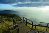
Summit of Doi Inthanon Summit of Doi Inthanon offers fine views to visitors, especially during November and December. On the summit, there is a stupa containing the body of prince Intharawichayonon, whose chronicle placed on the back of the marble plaque nearby. However photographing any parts of the radar station s forbidden.
![]()
Brichinda Cave This impressive limestone cave has a gigantic entrance camber and tower and a scene huge chamber with a skylight opening to the surface. This cave has a medium-size, which has beautiful stalagmite, is situated in the middle of deciduous forest. It takes about one hour walk from the main road.
![]()
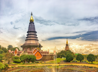
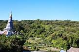
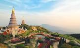
View Point and Phra Mahathat Chedi At Km. 41 of Chomthong-Doi Inthanon Road, there are Phra Mahathat Chedi Nophamethanidol and Phra Mahathat Noppholbhumisiri built for presenting to His Majesty the King and Her Majesty Queen Sirikit by Thai Air Force.
![]()
Wang Kwai Waterfall This waterfall has cold pleasant water which is suitable for swimming. Visitors can take route 00, Chiang Mai - Hod, turn right to route 00, Chom Tong - Doi Inthanon at 58 km. and proceed for another 9.7 km.
![]()
Siritan Waterfall This waterfall is 81 km. from Chiang Mai. Take the route 108, Chiang Mai - Hod and turn left at 58 th km. and continue on Chomg Tong - Doi Intanon for 23 km. you will reach Siritan Waterfall. The 100 meters trail in the Montain Rainforest will brighten up your day.
![]()
Doi Khun Klang Approximately km 31, the geographical area is surrounded by fields of grass due to reclamation of forests since 50 years ago, as a result, Doi Khun Klang looks wavy, particularly in the rainy season, the scenery of Doi Khun Klang is so greenish and spectacular for photographing. However, nature lovers wish to see the forests rather than the fields of grass.
![]()
Mae Pang Waterfall Group at Km. 6.6 on the Mae Chaem road is the turn-off to Mae Pang Waterfall. The laterite access road descends about two kilometers to the Mae Chaem Ranger Station and camp-ground, and is suitable for any vehicle although the road can be slippery on the uphill after a heavy rain. The area is quiet, of the beaten track, and can be described as the backcountry of Doi Inthanon Park. It offers a rewarding loop hike of 1 to 2 hours through untouched terrain with small waterfalls and tumbling creeks along most of the route. You can walk along the whole loop since it is largely un-marked, but any visitor can walk the 800 meters to Mae Pang waterfall and back again, as wall as the 200 meters to Huay Sai Luaeng waterall (just beyond the camp-ground).
![]()
![]()
Latitude : 18.536460325664336, Longitude : 98.52216681662138
View Larger Map

View On Google Map
Edit Data
Images
-
ดอยอินทนนท์ Doi Inthanon National Park
-
ดอยอินทนนท์ Doi Inthanon National Park
-
ดอยอินทนนท์ Doi Inthanon National Park
-
ดอยอินทนนท์ Doi Inthanon National Park
-

ดอยอินทนนท์ Doi Inthanon National Park
-

ดอยอินทนนท์ Doi Inthanon National Park